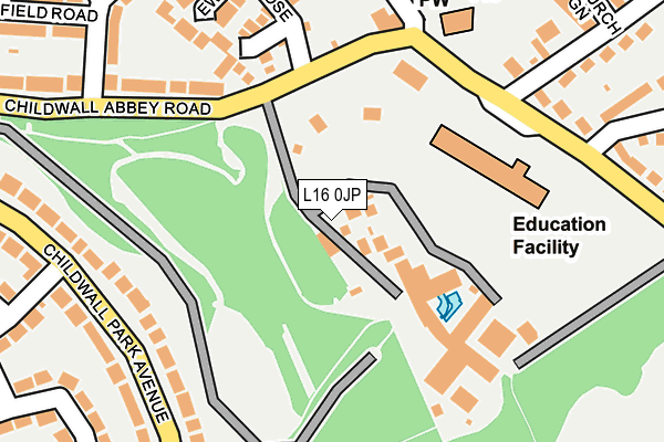
L16 0JP is located in the Childwall electoral ward, within the metropolitan district of Liverpool and the English Parliamentary constituency of Liverpool, Wavertree. The Sub Integrated Care Board (ICB) Location is NHS Cheshire and Merseyside ICB - 99A and the police force is Merseyside. This postcode has been in use since December 1994.


GetTheData
Source: OS OpenMap – Local (Ordnance Survey)
Source: OS VectorMap District (Ordnance Survey)
Licence: Open Government Licence (requires attribution)
| Easting | 341366 |
| Northing | 388899 |
| Latitude | 53.393652 |
| Longitude | -2.883184 |
GetTheData
Source: Open Postcode Geo
Licence: Open Government Licence
| Country | England |
| Postcode District | L16 |
| ➜ L16 open data dashboard ➜ See where L16 is on a map ➜ Where is Liverpool? | |
GetTheData
Source: Land Registry Price Paid Data
Licence: Open Government Licence
Elevation or altitude of L16 0JP as distance above sea level:
| Metres | Feet | |
|---|---|---|
| Elevation | 60m | 197ft |
Elevation is measured from the approximate centre of the postcode, to the nearest point on an OS contour line from OS Terrain 50, which has contour spacing of ten vertical metres.
➜ How high above sea level am I? Find the elevation of your current position using your device's GPS.
GetTheData
Source: Open Postcode Elevation
Licence: Open Government Licence
| Ward | Childwall |
| Constituency | Liverpool, Wavertree |
GetTheData
Source: ONS Postcode Database
Licence: Open Government Licence
| December 2023 | Violence and sexual offences | On or near Church Green | 308m |
| December 2023 | Violence and sexual offences | On or near Church Green | 308m |
| November 2023 | Violence and sexual offences | On or near Church Green | 308m |
| ➜ Get more crime data in our Crime section | |||
GetTheData
Source: data.police.uk
Licence: Open Government Licence
| Countisbury Drive (Childwall Park Avenue) | Childwall | 238m |
| Stand Park Road (Childwall Park Avenue) | Childwall | 246m |
| Stand Park Road (Childwall Park Avenue) | Childwall | 267m |
| Devon Way (Childwall Park Avenue) | Childwall | 297m |
| Viewpark Close (Barnham Drive) | Childwall | 379m |
| Broad Green Station | 1.6km |
| Roby Station | 2.6km |
| Mossley Hill Station | 2.7km |
GetTheData
Source: NaPTAN
Licence: Open Government Licence
GetTheData
Source: ONS Postcode Database
Licence: Open Government Licence


➜ Get more ratings from the Food Standards Agency
GetTheData
Source: Food Standards Agency
Licence: FSA terms & conditions
| Last Collection | |||
|---|---|---|---|
| Location | Mon-Fri | Sat | Distance |
| Childwall Abbey | 16:00 | 12:00 | 189m |
| Standpark Road | 16:00 | 12:00 | 257m |
| North Barcombe Road | 16:00 | 12:00 | 444m |
GetTheData
Source: Dracos
Licence: Creative Commons Attribution-ShareAlike
| Facility | Distance |
|---|---|
| Ashfield School (Closed) Childwall Abbey Road, Liverpool Grass Pitches | 143m |
| Barnham Drive Playing Fields Barnham Drive, Liverpool Grass Pitches | 611m |
| Hope Park Sports Taggart Avenue, Liverpool Sports Hall, Health and Fitness Gym, Grass Pitches, Artificial Grass Pitch, Squash Courts | 628m |
GetTheData
Source: Active Places
Licence: Open Government Licence
| School | Phase of Education | Distance |
|---|---|---|
| Childwall Abbey School Childwall Abbey Road, Childwall, Liverpool, L16 5EY | Not applicable | 148m |
| Liverpool Hope University Hope Park, Liverpool, L16 9JD | Not applicable | 630m |
| Childwall Church of England Primary School Woolton Road, Liverpool, L16 0JD | Primary | 718m |
GetTheData
Source: Edubase
Licence: Open Government Licence
The below table lists the International Territorial Level (ITL) codes (formerly Nomenclature of Territorial Units for Statistics (NUTS) codes) and Local Administrative Units (LAU) codes for L16 0JP:
| ITL 1 Code | Name |
|---|---|
| TLD | North West (England) |
| ITL 2 Code | Name |
| TLD7 | Merseyside |
| ITL 3 Code | Name |
| TLD72 | Liverpool |
| LAU 1 Code | Name |
| E08000012 | Liverpool |
GetTheData
Source: ONS Postcode Directory
Licence: Open Government Licence
The below table lists the Census Output Area (OA), Lower Layer Super Output Area (LSOA), and Middle Layer Super Output Area (MSOA) for L16 0JP:
| Code | Name | |
|---|---|---|
| OA | E00033348 | |
| LSOA | E01006583 | Liverpool 047C |
| MSOA | E02001393 | Liverpool 047 |
GetTheData
Source: ONS Postcode Directory
Licence: Open Government Licence
| L16 0JW | Childwall Abbey Road | 92m |
| L16 5HF | Ewden Close | 218m |
| L16 0JE | Childwall Park Avenue | 229m |
| L16 5EZ | Abbey View | 262m |
| L16 0JQ | Childwall Park Avenue | 271m |
| L16 7QE | South Barcombe Road | 276m |
| L25 1PL | Childwall Lane | 277m |
| L16 0JL | Childwall Abbey Road | 299m |
| L16 7QF | South Barcombe Road | 317m |
| L16 9JP | Devon Way | 323m |
GetTheData
Source: Open Postcode Geo; Land Registry Price Paid Data
Licence: Open Government Licence