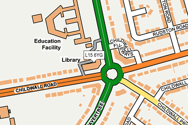
L15 6YG is located in the Wavertree Garden Suburb electoral ward, within the metropolitan district of Liverpool and the English Parliamentary constituency of Liverpool, Wavertree. The Sub Integrated Care Board (ICB) Location is NHS Cheshire and Merseyside ICB - 99A and the police force is Merseyside. This postcode has been in use since January 1980.


GetTheData
Source: OS OpenMap – Local (Ordnance Survey)
Source: OS VectorMap District (Ordnance Survey)
Licence: Open Government Licence (requires attribution)
| Easting | 340394 |
| Northing | 389346 |
| Latitude | 53.397561 |
| Longitude | -2.897884 |
GetTheData
Source: Open Postcode Geo
Licence: Open Government Licence
| Country | England |
| Postcode District | L15 |
| ➜ L15 open data dashboard ➜ See where L15 is on a map ➜ Where is Liverpool? | |
GetTheData
Source: Land Registry Price Paid Data
Licence: Open Government Licence
Elevation or altitude of L15 6YG as distance above sea level:
| Metres | Feet | |
|---|---|---|
| Elevation | 50m | 164ft |
Elevation is measured from the approximate centre of the postcode, to the nearest point on an OS contour line from OS Terrain 50, which has contour spacing of ten vertical metres.
➜ How high above sea level am I? Find the elevation of your current position using your device's GPS.
GetTheData
Source: Open Postcode Elevation
Licence: Open Government Licence
| Ward | Wavertree Garden Suburb |
| Constituency | Liverpool, Wavertree |
GetTheData
Source: ONS Postcode Database
Licence: Open Government Licence
| June 2022 | Public order | On or near Queens Drive (Wavertree) | 130m |
| June 2022 | Anti-social behaviour | On or near Queens Drive (Wavertree) | 130m |
| June 2022 | Violence and sexual offences | On or near Belston Road | 212m |
| ➜ Get more crime data in our Crime section | |||
GetTheData
Source: data.police.uk
Licence: Open Government Licence
| Queens Drive (Childwall Road) | Childwall | 40m |
| Fiveways (Childwall Road) | Childwall | 64m |
| Childwall Valley Road (Queens Drive) | Childwall | 66m |
| Childwall Fiveways (Childwall Valley Road) | Childwall | 129m |
| Childwall Fiveways (Queens Drive) | Wavertree | 130m |
| Broad Green Station | 1km |
| Wavertree Technology Park Station | 1.9km |
| Mossley Hill Station | 2.4km |
GetTheData
Source: NaPTAN
Licence: Open Government Licence
GetTheData
Source: ONS Postcode Database
Licence: Open Government Licence


➜ Get more ratings from the Food Standards Agency
GetTheData
Source: Food Standards Agency
Licence: FSA terms & conditions
| Last Collection | |||
|---|---|---|---|
| Location | Mon-Fri | Sat | Distance |
| Childwall Priory Road | 16:00 | 12:00 | 145m |
| Dunbabin Road | 16:00 | 12:00 | 391m |
| Beauclair Drive | 16:00 | 12:00 | 483m |
GetTheData
Source: Dracos
Licence: Creative Commons Attribution-ShareAlike
| Facility | Distance |
|---|---|
| Childwall Sports And Science Academy Queens Drive, Wavertree, Liverpool Health and Fitness Gym, Sports Hall, Grass Pitches, Studio | 148m |
| King David High School (Closed) Childwall Road, Liverpool Swimming Pool, Sports Hall | 240m |
| King David High School Childwall Road, Liverpool Swimming Pool, Sports Hall, Grass Pitches | 240m |
GetTheData
Source: Active Places
Licence: Open Government Licence
| School | Phase of Education | Distance |
|---|---|---|
| Childwall Sports & Science Academy Queen's Drive, Liverpool, L15 6XZ | Secondary | 204m |
| King David High School 116 Childwall Road, Liverpool, L15 6WU | Secondary | 240m |
| King David Primary School Childwall Rd, Liverpool, L15 6WU | Primary | 297m |
GetTheData
Source: Edubase
Licence: Open Government Licence
The below table lists the International Territorial Level (ITL) codes (formerly Nomenclature of Territorial Units for Statistics (NUTS) codes) and Local Administrative Units (LAU) codes for L15 6YG:
| ITL 1 Code | Name |
|---|---|
| TLD | North West (England) |
| ITL 2 Code | Name |
| TLD7 | Merseyside |
| ITL 3 Code | Name |
| TLD72 | Liverpool |
| LAU 1 Code | Name |
| E08000012 | Liverpool |
GetTheData
Source: ONS Postcode Directory
Licence: Open Government Licence
The below table lists the Census Output Area (OA), Lower Layer Super Output Area (LSOA), and Middle Layer Super Output Area (MSOA) for L15 6YG:
| Code | Name | |
|---|---|---|
| OA | E00033339 | |
| LSOA | E01006582 | Liverpool 041A |
| MSOA | E02001387 | Liverpool 041 |
GetTheData
Source: ONS Postcode Directory
Licence: Open Government Licence
| L15 6YB | Childwall Fiveways | 85m |
| L15 6UY | Childwall Road | 108m |
| L15 6YA | Grosvenor Court | 121m |
| L15 6UT | Childwall Road | 134m |
| L15 6XT | Queens Drive | 156m |
| L16 4PH | Rudston Road | 176m |
| L16 4PB | Childwall Valley Road | 214m |
| L16 4PG | Rudston Road | 217m |
| L15 6XU | Queens Drive | 240m |
| L16 7QN | Corbridge Road | 240m |
GetTheData
Source: Open Postcode Geo; Land Registry Price Paid Data
Licence: Open Government Licence