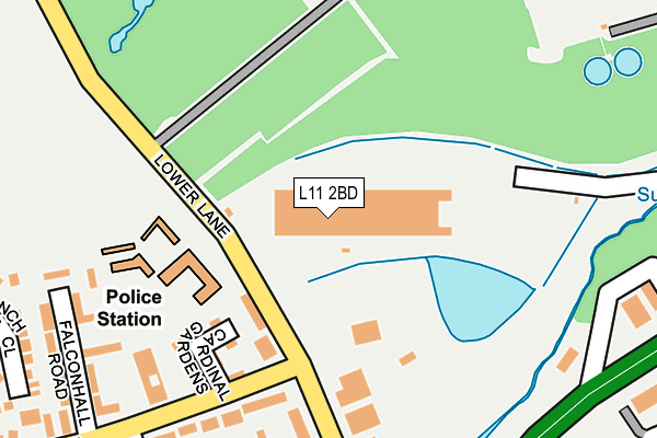
L11 2BD is located in the Fazakerley East electoral ward, within the metropolitan district of Liverpool and the English Parliamentary constituency of Liverpool, Walton. The Sub Integrated Care Board (ICB) Location is NHS Cheshire and Merseyside ICB - 99A and the police force is Merseyside. This postcode has been in use since September 2015.


GetTheData
Source: OS OpenMap – Local (Ordnance Survey)
Source: OS VectorMap District (Ordnance Survey)
Licence: Open Government Licence (requires attribution)
| Easting | 339402 |
| Northing | 396103 |
| Latitude | 53.458191 |
| Longitude | -2.914102 |
GetTheData
Source: Open Postcode Geo
Licence: Open Government Licence
| Country | England |
| Postcode District | L11 |
➜ See where L11 is on a map ➜ Where is Liverpool? | |
GetTheData
Source: Land Registry Price Paid Data
Licence: Open Government Licence
Elevation or altitude of L11 2BD as distance above sea level:
| Metres | Feet | |
|---|---|---|
| Elevation | 20m | 66ft |
Elevation is measured from the approximate centre of the postcode, to the nearest point on an OS contour line from OS Terrain 50, which has contour spacing of ten vertical metres.
➜ How high above sea level am I? Find the elevation of your current position using your device's GPS.
GetTheData
Source: Open Postcode Elevation
Licence: Open Government Licence
| Ward | Fazakerley East |
| Constituency | Liverpool, Walton |
GetTheData
Source: ONS Postcode Database
Licence: Open Government Licence
| Showcase Cinema (East Lancashire Road) | Croxteth | 164m |
| Stonebridge Lane (East Lancashire Road) | Croxteth | 188m |
| Showcase Cinema (East Lancashire Road) | Croxteth | 192m |
| East Lancashire Road (Stonebridge Lane) | Croxteth | 267m |
| East Lancashire Road (Stonebridge Lane) | Croxteth | 295m |
| Fazakerley Station | 1.9km |
| Rice Lane Station | 3.2km |
| Kirkby Station | 3.2km |
GetTheData
Source: NaPTAN
Licence: Open Government Licence
GetTheData
Source: ONS Postcode Database
Licence: Open Government Licence

➜ Get more ratings from the Food Standards Agency
GetTheData
Source: Food Standards Agency
Licence: FSA terms & conditions
| Last Collection | |||
|---|---|---|---|
| Location | Mon-Fri | Sat | Distance |
| Copplehouse Lane | 16:00 | 12:00 | 1,050m |
| Amanda Road | 16:00 | 12:00 | 1,286m |
| Longmoor Lane Post Office | 17:00 | 12:00 | 1,352m |
GetTheData
Source: Dracos
Licence: Creative Commons Attribution-ShareAlike
| Risk of L11 2BD flooding from rivers and sea | High |
| ➜ L11 2BD flood map | |
GetTheData
Source: Open Flood Risk by Postcode
Licence: Open Government Licence
The below table lists the International Territorial Level (ITL) codes (formerly Nomenclature of Territorial Units for Statistics (NUTS) codes) and Local Administrative Units (LAU) codes for L11 2BD:
| ITL 1 Code | Name |
|---|---|
| TLD | North West (England) |
| ITL 2 Code | Name |
| TLD7 | Merseyside |
| ITL 3 Code | Name |
| TLD72 | Liverpool |
| LAU 1 Code | Name |
| E08000012 | Liverpool |
GetTheData
Source: ONS Postcode Directory
Licence: Open Government Licence
The below table lists the Census Output Area (OA), Lower Layer Super Output Area (LSOA), and Middle Layer Super Output Area (MSOA) for L11 2BD:
| Code | Name | |
|---|---|---|
| OA | E00033703 | |
| LSOA | E01006660 | Liverpool 001E |
| MSOA | E02001347 | Liverpool 001 |
GetTheData
Source: ONS Postcode Directory
Licence: Open Government Licence
| L11 9BS | Stonedale Crescent | 262m |
| L11 9BR | Stonedale Crescent | 303m |
| L11 9DH | Stonedale Park | 318m |
| L11 9BU | Stonedale Crescent | 387m |
| L11 9DE | Dalcross Way | 418m |
| L11 9BX | Stonedale Crescent | 495m |
| L9 6DL | Lower Lane | 541m |
| L11 9BZ | Stonedale Crescent | 564m |
| L11 9BY | Stonedale Crescent | 574m |
| L9 6DH | Ternhall Way | 616m |
GetTheData
Source: Open Postcode Geo; Land Registry Price Paid Data
Licence: Open Government Licence