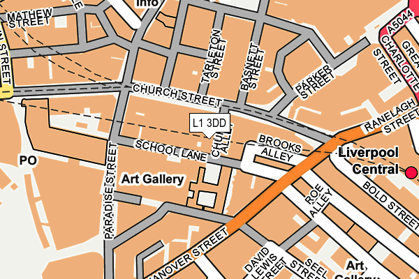
L1 3DD is located in the City Centre North electoral ward, within the metropolitan district of Liverpool and the English Parliamentary constituency of Liverpool, Riverside. The Sub Integrated Care Board (ICB) Location is NHS Cheshire and Merseyside ICB - 99A and the police force is Merseyside. This postcode has been in use since January 1980.


GetTheData
Source: OS OpenMap – Local (Ordnance Survey)
Source: OS VectorMap District (Ordnance Survey)
Licence: Open Government Licence (requires attribution)
| Easting | 334681 |
| Northing | 390203 |
| Latitude | 53.404603 |
| Longitude | -2.983966 |
GetTheData
Source: Open Postcode Geo
Licence: Open Government Licence
| Country | England |
| Postcode District | L1 |
| ➜ L1 open data dashboard ➜ See where L1 is on a map ➜ Where is Liverpool? | |
GetTheData
Source: Land Registry Price Paid Data
Licence: Open Government Licence
Elevation or altitude of L1 3DD as distance above sea level:
| Metres | Feet | |
|---|---|---|
| Elevation | 10m | 33ft |
Elevation is measured from the approximate centre of the postcode, to the nearest point on an OS contour line from OS Terrain 50, which has contour spacing of ten vertical metres.
➜ How high above sea level am I? Find the elevation of your current position using your device's GPS.
GetTheData
Source: Open Postcode Elevation
Licence: Open Government Licence
| Ward | City Centre North |
| Constituency | Liverpool, Riverside |
GetTheData
Source: ONS Postcode Database
Licence: Open Government Licence
| December 2023 | Violence and sexual offences | On or near Nightclub | 418m |
| December 2023 | Violence and sexual offences | On or near Nightclub | 418m |
| December 2023 | Vehicle crime | On or near Heathfield Street | 456m |
| ➜ Get more crime data in our Crime section | |||
GetTheData
Source: data.police.uk
Licence: Open Government Licence
| Hanover Street | Liverpool | 99m |
| Hanover Street | Liverpool | 100m |
| Seel Street (Hanover Street) | Liverpool | 127m |
| Campbell Street (Duke Street) | Liverpool | 266m |
| Sir Thomas Street | Liverpool | 277m |
| Liverpool Central Station | 0.3km |
| Liverpool Lime Street Station | 0.5km |
| Liverpool James Street Station | 0.5km |
GetTheData
Source: NaPTAN
Licence: Open Government Licence
GetTheData
Source: ONS Postcode Database
Licence: Open Government Licence


➜ Get more ratings from the Food Standards Agency
GetTheData
Source: Food Standards Agency
Licence: FSA terms & conditions
| Last Collection | |||
|---|---|---|---|
| Location | Mon-Fri | Sat | Distance |
| Church Street | 18:30 | 12:00 | 99m |
| Paradise Street | 18:30 | 12:00 | 130m |
| Lyceum | 18:30 | 12:00 | 196m |
GetTheData
Source: Dracos
Licence: Creative Commons Attribution-ShareAlike
| Facility | Distance |
|---|---|
| The Gym Group (Liverpool Central) Clayton Square Shopping Centre, Liverpool Health and Fitness Gym | 183m |
| Club Moativation (Liverpool) (Closed) Paradise Street, Liverpool Studio, Health and Fitness Gym, Swimming Pool | 208m |
| Puregym (Liverpool Central) Ranelagh Street, Liverpool Health and Fitness Gym, Studio | 358m |
GetTheData
Source: Active Places
Licence: Open Government Licence
| School | Phase of Education | Distance |
|---|---|---|
| St Vincent de Paul Catholic Primary School St Vincent de Paul Catholic Primary School Pitt Street, Liverpool, L1 5BY | Primary | 543m |
| Pleasant Street Primary School Pleasant Street, Liverpool, L3 5TS | Primary | 658m |
| The City of Liverpool College Clarence Street, Liverpool, L3 5TP | 16 plus | 716m |
GetTheData
Source: Edubase
Licence: Open Government Licence
The below table lists the International Territorial Level (ITL) codes (formerly Nomenclature of Territorial Units for Statistics (NUTS) codes) and Local Administrative Units (LAU) codes for L1 3DD:
| ITL 1 Code | Name |
|---|---|
| TLD | North West (England) |
| ITL 2 Code | Name |
| TLD7 | Merseyside |
| ITL 3 Code | Name |
| TLD72 | Liverpool |
| LAU 1 Code | Name |
| E08000012 | Liverpool |
GetTheData
Source: ONS Postcode Directory
Licence: Open Government Licence
The below table lists the Census Output Area (OA), Lower Layer Super Output Area (LSOA), and Middle Layer Super Output Area (MSOA) for L1 3DD:
| Code | Name | |
|---|---|---|
| OA | E00176629 | |
| LSOA | E01033756 | Liverpool 061C |
| MSOA | E02006933 | Liverpool 061 |
GetTheData
Source: ONS Postcode Directory
Licence: Open Government Licence
| L1 1DE | Church Street | 104m |
| L1 3DZ | Hanover Street | 106m |
| L1 1DS | Tarleton Street | 150m |
| L2 1TL | Lord Street | 171m |
| L1 1EF | Richmond Street | 200m |
| L1 1DP | Clayton Square | 203m |
| L2 6PS | Button Street | 224m |
| L1 6AU | Stanley Street | 224m |
| L1 4JH | Gradwell Street | 228m |
| L1 4AA | Hanover Street | 229m |
GetTheData
Source: Open Postcode Geo; Land Registry Price Paid Data
Licence: Open Government Licence