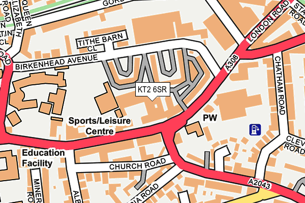
KT2 6SR is located in the Norbiton electoral ward, within the London borough of Kingston upon Thames and the English Parliamentary constituency of Kingston and Surbiton. The Sub Integrated Care Board (ICB) Location is NHS South West London ICB - 36L and the police force is Metropolitan Police. This postcode has been in use since July 1995.


GetTheData
Source: OS OpenMap – Local (Ordnance Survey)
Source: OS VectorMap District (Ordnance Survey)
Licence: Open Government Licence (requires attribution)
| Easting | 518849 |
| Northing | 169413 |
| Latitude | 51.411292 |
| Longitude | -0.292469 |
GetTheData
Source: Open Postcode Geo
Licence: Open Government Licence
| Country | England |
| Postcode District | KT2 |
| ➜ KT2 open data dashboard ➜ See where KT2 is on a map ➜ Where is Kingston upon Thames? | |
GetTheData
Source: Land Registry Price Paid Data
Licence: Open Government Licence
Elevation or altitude of KT2 6SR as distance above sea level:
| Metres | Feet | |
|---|---|---|
| Elevation | 10m | 33ft |
Elevation is measured from the approximate centre of the postcode, to the nearest point on an OS contour line from OS Terrain 50, which has contour spacing of ten vertical metres.
➜ How high above sea level am I? Find the elevation of your current position using your device's GPS.
GetTheData
Source: Open Postcode Elevation
Licence: Open Government Licence
| Ward | Norbiton |
| Constituency | Kingston And Surbiton |
GetTheData
Source: ONS Postcode Database
Licence: Open Government Licence
| January 2024 | Violence and sexual offences | On or near Camm Gardens | 150m |
| January 2024 | Other theft | On or near Canbury Park Road | 298m |
| January 2024 | Other theft | On or near Kingsworthy Close | 459m |
| ➜ Get more crime data in our Crime section | |||
GetTheData
Source: data.police.uk
Licence: Open Government Licence
| Norbiton Church (London Road) | Kingston Upon Thames | 57m |
| Norbiton Church | Kingston Upon Thames | 82m |
| Vicarage House (Cambridge Road) | Norbiton | 133m |
| Gordon Road (Kt2) | Norbiton | 164m |
| Vicarage House (Cambridge Road) | Norbiton | 169m |
| Norbiton Station | 0.6km |
| Kingston Station | 0.6km |
| Hampton Wick Station | 1.4km |
GetTheData
Source: NaPTAN
Licence: Open Government Licence
GetTheData
Source: ONS Postcode Database
Licence: Open Government Licence


➜ Get more ratings from the Food Standards Agency
GetTheData
Source: Food Standards Agency
Licence: FSA terms & conditions
| Last Collection | |||
|---|---|---|---|
| Location | Mon-Fri | Sat | Distance |
| 141 London Road | 17:30 | 12:00 | 98m |
| Birkenhead Avenue | 17:30 | 12:00 | 144m |
| Victoria Road | 17:30 | 12:00 | 179m |
GetTheData
Source: Dracos
Licence: Creative Commons Attribution-ShareAlike
| Facility | Distance |
|---|---|
| Tiffin School Sports Centre Queen Elizabeth Road, Kingston Upon Thames Sports Hall, Studio, Artificial Grass Pitch, Health and Fitness Gym | 224m |
| David Lloyd (Kingston) Clarence Street, Kingston Upon Thames Swimming Pool, Health and Fitness Gym, Studio | 480m |
| Kingfisher Leisure Centre (Kingston) (Closed) Fairfield Road, Kingston Upon Thames Swimming Pool, Health and Fitness Gym, Studio, Squash Courts | 522m |
GetTheData
Source: Active Places
Licence: Open Government Licence
| School | Phase of Education | Distance |
|---|---|---|
| Tiffin School Queen Elizabeth Road, Kingston upon Thames, KT2 6RL | Secondary | 228m |
| Kingston Grammar School London Road, Kingston upon Thames, KT2 6PY | Not applicable | 299m |
| St Joseph's Catholic Primary School The Fairfield, Kingston upon Thames, KT1 2UP | Primary | 351m |
GetTheData
Source: Edubase
Licence: Open Government Licence
The below table lists the International Territorial Level (ITL) codes (formerly Nomenclature of Territorial Units for Statistics (NUTS) codes) and Local Administrative Units (LAU) codes for KT2 6SR:
| ITL 1 Code | Name |
|---|---|
| TLI | London |
| ITL 2 Code | Name |
| TLI6 | Outer London - South |
| ITL 3 Code | Name |
| TLI63 | Merton, Kingston upon Thames and Sutton |
| LAU 1 Code | Name |
| E09000021 | Kingston upon Thames |
GetTheData
Source: ONS Postcode Directory
Licence: Open Government Licence
The below table lists the Census Output Area (OA), Lower Layer Super Output Area (LSOA), and Middle Layer Super Output Area (MSOA) for KT2 6SR:
| Code | Name | |
|---|---|---|
| OA | E00014960 | |
| LSOA | E01002971 | Kingston upon Thames 005C |
| MSOA | E02000602 | Kingston upon Thames 005 |
GetTheData
Source: ONS Postcode Directory
Licence: Open Government Licence
| KT2 6RS | Birkenhead Avenue | 55m |
| KT2 6RT | Birkenhead Avenue | 68m |
| KT2 6QJ | London Road | 79m |
| KT2 6RU | Birkenhead Avenue | 86m |
| KT2 6RR | Birkenhead Avenue | 88m |
| KT2 6RA | London Road | 90m |
| KT2 6GW | Cambridge Road | 93m |
| KT2 6QL | London Road | 120m |
| KT1 3JR | Church Road | 121m |
| KT2 6NH | London Road | 123m |
GetTheData
Source: Open Postcode Geo; Land Registry Price Paid Data
Licence: Open Government Licence