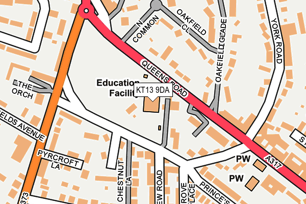
KT13 9DA is located in the Weybridge St George's Hill electoral ward, within the local authority district of Elmbridge and the English Parliamentary constituency of Runnymede and Weybridge. The Sub Integrated Care Board (ICB) Location is NHS Surrey Heartlands ICB - 92A and the police force is Surrey. This postcode has been in use since January 1980.


GetTheData
Source: OS OpenMap – Local (Ordnance Survey)
Source: OS VectorMap District (Ordnance Survey)
Licence: Open Government Licence (requires attribution)
| Easting | 508035 |
| Northing | 164494 |
| Latitude | 51.369240 |
| Longitude | -0.449414 |
GetTheData
Source: Open Postcode Geo
Licence: Open Government Licence
| Country | England |
| Postcode District | KT13 |
| ➜ KT13 open data dashboard ➜ See where KT13 is on a map ➜ Where is Weybridge? | |
GetTheData
Source: Land Registry Price Paid Data
Licence: Open Government Licence
Elevation or altitude of KT13 9DA as distance above sea level:
| Metres | Feet | |
|---|---|---|
| Elevation | 30m | 98ft |
Elevation is measured from the approximate centre of the postcode, to the nearest point on an OS contour line from OS Terrain 50, which has contour spacing of ten vertical metres.
➜ How high above sea level am I? Find the elevation of your current position using your device's GPS.
GetTheData
Source: Open Postcode Elevation
Licence: Open Government Licence
| Ward | Weybridge St George's Hill |
| Constituency | Runnymede And Weybridge |
GetTheData
Source: ONS Postcode Database
Licence: Open Government Licence
| January 2024 | Burglary | On or near Layton Court | 342m |
| November 2023 | Criminal damage and arson | On or near Pyrcroft Lane | 213m |
| November 2023 | Anti-social behaviour | On or near Layton Court | 342m |
| ➜ Get more crime data in our Crime section | |||
GetTheData
Source: data.police.uk
Licence: Open Government Licence
| York Road (Queens Road) | Weybridge | 121m |
| York Road (Queens Road) | Weybridge | 165m |
| Temple Market (Queens Road) | Weybridge | 199m |
| Temple Market (Queens Road) | Weybridge | 204m |
| Princes Road (Hanger Hill) | Weybridge | 209m |
| Weybridge Station | 1km |
| Walton-on-Thames Station | 2.5km |
| Addlestone Station | 2.5km |
GetTheData
Source: NaPTAN
Licence: Open Government Licence
GetTheData
Source: ONS Postcode Database
Licence: Open Government Licence


➜ Get more ratings from the Food Standards Agency
GetTheData
Source: Food Standards Agency
Licence: FSA terms & conditions
| Last Collection | |||
|---|---|---|---|
| Location | Mon-Fri | Sat | Distance |
| Beechfield | 17:45 | 12:15 | 195m |
| Queens Road Post Office | 18:30 | 12:15 | 208m |
| The Common | 17:45 | 12:30 | 211m |
GetTheData
Source: Dracos
Licence: Creative Commons Attribution-ShareAlike
| Facility | Distance |
|---|---|
| Weybridge Cricket Club Princes Road, Weybridge Grass Pitches | 45m |
| Oatlands Park Barham Close, Weybridge Outdoor Tennis Courts | 598m |
| Churchfields Recreation Ground Churchfield Road, Weybridge Outdoor Tennis Courts | 638m |
GetTheData
Source: Active Places
Licence: Open Government Licence
| School | Phase of Education | Distance |
|---|---|---|
| Manby Lodge Infant School Princes Road, Weybridge, KT13 9DA | Primary | 1m |
| St James CofE Primary School Grotto Road, Weybridge, KT13 8PL | Primary | 648m |
| Oatlands School St Marys Road, Weybridge, KT13 9PZ | Primary | 851m |
GetTheData
Source: Edubase
Licence: Open Government Licence
The below table lists the International Territorial Level (ITL) codes (formerly Nomenclature of Territorial Units for Statistics (NUTS) codes) and Local Administrative Units (LAU) codes for KT13 9DA:
| ITL 1 Code | Name |
|---|---|
| TLJ | South East (England) |
| ITL 2 Code | Name |
| TLJ2 | Surrey, East and West Sussex |
| ITL 3 Code | Name |
| TLJ25 | West Surrey |
| LAU 1 Code | Name |
| E07000207 | Elmbridge |
GetTheData
Source: ONS Postcode Directory
Licence: Open Government Licence
The below table lists the Census Output Area (OA), Lower Layer Super Output Area (LSOA), and Middle Layer Super Output Area (MSOA) for KT13 9DA:
| Code | Name | |
|---|---|---|
| OA | E00154931 | |
| LSOA | E01030375 | Elmbridge 012E |
| MSOA | E02006328 | Elmbridge 012 |
GetTheData
Source: ONS Postcode Directory
Licence: Open Government Licence
| KT13 9DB | Princes Road | 42m |
| KT13 9XF | Queens Road | 81m |
| KT13 9UE | Queens Road | 83m |
| KT13 9BT | Princes Road | 107m |
| KT13 9BN | Princes Road | 118m |
| KT13 9BX | Leavesden Road | 132m |
| KT13 9DW | Oakfield Close | 133m |
| KT13 9BY | Princes Road | 134m |
| KT13 9XE | Queens Road | 140m |
| KT13 9UF | Queens Road | 152m |
GetTheData
Source: Open Postcode Geo; Land Registry Price Paid Data
Licence: Open Government Licence