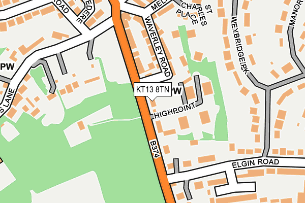
KT13 8TN is located in the Weybridge Riverside electoral ward, within the local authority district of Elmbridge and the English Parliamentary constituency of Runnymede and Weybridge. The Sub Integrated Care Board (ICB) Location is NHS Surrey Heartlands ICB - 92A and the police force is Surrey. This postcode has been in use since January 1980.


GetTheData
Source: OS OpenMap – Local (Ordnance Survey)
Source: OS VectorMap District (Ordnance Survey)
Licence: Open Government Licence (requires attribution)
| Easting | 507309 |
| Northing | 164145 |
| Latitude | 51.366241 |
| Longitude | -0.459944 |
GetTheData
Source: Open Postcode Geo
Licence: Open Government Licence
| Country | England |
| Postcode District | KT13 |
| ➜ KT13 open data dashboard ➜ See where KT13 is on a map ➜ Where is Weybridge? | |
GetTheData
Source: Land Registry Price Paid Data
Licence: Open Government Licence
Elevation or altitude of KT13 8TN as distance above sea level:
| Metres | Feet | |
|---|---|---|
| Elevation | 30m | 98ft |
Elevation is measured from the approximate centre of the postcode, to the nearest point on an OS contour line from OS Terrain 50, which has contour spacing of ten vertical metres.
➜ How high above sea level am I? Find the elevation of your current position using your device's GPS.
GetTheData
Source: Open Postcode Elevation
Licence: Open Government Licence
| Ward | Weybridge Riverside |
| Constituency | Runnymede And Weybridge |
GetTheData
Source: ONS Postcode Database
Licence: Open Government Licence
| August 2023 | Vehicle crime | On or near Molyneux Road | 318m |
| June 2023 | Violence and sexual offences | On or near St Charles Place | 198m |
| April 2023 | Burglary | On or near Molyneux Road | 318m |
| ➜ Get more crime data in our Crime section | |||
GetTheData
Source: data.police.uk
Licence: Open Government Licence
| Elgin Road (Heath Road) | Weybridge | 90m |
| Melrose Road (Heath Road) | Weybridge | 128m |
| Elgin Road (Heath Road) | Weybridge | 134m |
| Melrose Road (Heath Road) | Weybridge | 239m |
| Weybridge Railway Station North (Heath Road) | Weybridge | 396m |
| Weybridge Station | 0.5km |
| Addlestone Station | 1.9km |
| Byfleet & New Haw Station | 2.4km |
GetTheData
Source: NaPTAN
Licence: Open Government Licence
GetTheData
Source: ONS Postcode Database
Licence: Open Government Licence


➜ Get more ratings from the Food Standards Agency
GetTheData
Source: Food Standards Agency
Licence: FSA terms & conditions
| Last Collection | |||
|---|---|---|---|
| Location | Mon-Fri | Sat | Distance |
| Heath Road | 18:30 | 12:30 | 170m |
| Weybridge Railway Station | 17:30 | 12:30 | 505m |
| Hanger Hill | 17:45 | 12:30 | 506m |
GetTheData
Source: Dracos
Licence: Creative Commons Attribution-ShareAlike
| Facility | Distance |
|---|---|
| Heathside School Brooklands Lane, Weybridge Grass Pitches, Sports Hall, Outdoor Tennis Courts | 406m |
| Churchfields Recreation Ground Churchfield Road, Weybridge Outdoor Tennis Courts | 522m |
| Brooklands College (Weybridge Campus) Heath Road, Weybridge Sports Hall, Health and Fitness Gym | 555m |
GetTheData
Source: Active Places
Licence: Open Government Licence
| School | Phase of Education | Distance |
|---|---|---|
| Heathside School Brooklands Lane, Weybridge, KT13 8UZ | Secondary | 406m |
| Brooklands College Heath Road, Weybridge, KT13 8TT | 16 plus | 555m |
| Manby Lodge Infant School Princes Road, Weybridge, KT13 9DA | Primary | 807m |
GetTheData
Source: Edubase
Licence: Open Government Licence
The below table lists the International Territorial Level (ITL) codes (formerly Nomenclature of Territorial Units for Statistics (NUTS) codes) and Local Administrative Units (LAU) codes for KT13 8TN:
| ITL 1 Code | Name |
|---|---|
| TLJ | South East (England) |
| ITL 2 Code | Name |
| TLJ2 | Surrey, East and West Sussex |
| ITL 3 Code | Name |
| TLJ25 | West Surrey |
| LAU 1 Code | Name |
| E07000207 | Elmbridge |
GetTheData
Source: ONS Postcode Directory
Licence: Open Government Licence
The below table lists the Census Output Area (OA), Lower Layer Super Output Area (LSOA), and Middle Layer Super Output Area (MSOA) for KT13 8TN:
| Code | Name | |
|---|---|---|
| OA | E00154934 | |
| LSOA | E01030376 | Elmbridge 012F |
| MSOA | E02006328 | Elmbridge 012 |
GetTheData
Source: ONS Postcode Directory
Licence: Open Government Licence
| KT13 8TP | High Point | 70m |
| KT13 8TW | High Point | 110m |
| KT13 8UT | Waverley Road | 114m |
| KT13 8TJ | Heath Road | 115m |
| KT13 8JH | St Charles Place | 127m |
| KT13 8ST | Elgin Road | 134m |
| KT13 8TL | Heath Road | 148m |
| KT13 8TS | Heath Road | 163m |
| KT13 8SW | Elgin Road | 166m |
| KT13 8TH | Heath Road | 183m |
GetTheData
Source: Open Postcode Geo; Land Registry Price Paid Data
Licence: Open Government Licence