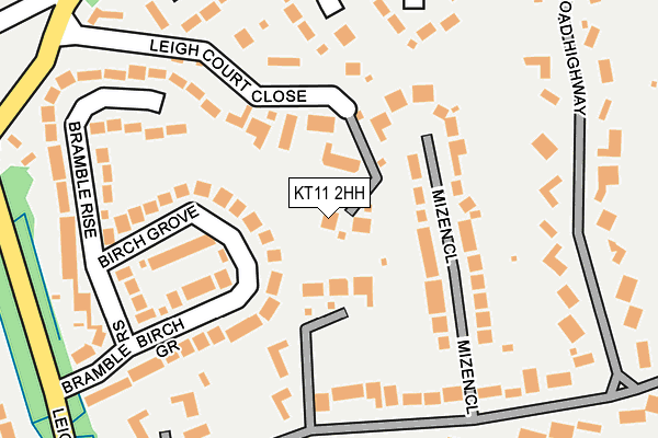
KT11 2HH lies on Leigh Court in Cobham. KT11 2HH is located in the Cobham and Downside electoral ward, within the local authority district of Elmbridge and the English Parliamentary constituency of Esher and Walton. The Sub Integrated Care Board (ICB) Location is NHS Surrey Heartlands ICB - 92A and the police force is Surrey. This postcode has been in use since June 2005.


GetTheData
Source: OS OpenMap – Local (Ordnance Survey)
Source: OS VectorMap District (Ordnance Survey)
Licence: Open Government Licence (requires attribution)
| Easting | 511599 |
| Northing | 160233 |
| Latitude | 51.330252 |
| Longitude | -0.399548 |
GetTheData
Source: Open Postcode Geo
Licence: Open Government Licence
| Street | Leigh Court |
| Town/City | Cobham |
| Country | England |
| Postcode District | KT11 |
| ➜ KT11 open data dashboard ➜ See where KT11 is on a map ➜ Where is Cobham? | |
GetTheData
Source: Land Registry Price Paid Data
Licence: Open Government Licence
Elevation or altitude of KT11 2HH as distance above sea level:
| Metres | Feet | |
|---|---|---|
| Elevation | 30m | 98ft |
Elevation is measured from the approximate centre of the postcode, to the nearest point on an OS contour line from OS Terrain 50, which has contour spacing of ten vertical metres.
➜ How high above sea level am I? Find the elevation of your current position using your device's GPS.
GetTheData
Source: Open Postcode Elevation
Licence: Open Government Licence
| Ward | Cobham And Downside |
| Constituency | Esher And Walton |
GetTheData
Source: ONS Postcode Database
Licence: Open Government Licence
2019 8 NOV £2,450,000 |
BEECH HOUSE, 2, LEIGH COURT, COBHAM, KT11 2HH 2019 13 AUG £2,155,000 |
2013 28 MAR £2,160,000 |
HILL HOUSE, 3, LEIGH COURT, COBHAM, KT11 2HH 2006 21 DEC £1,725,000 |
2006 23 MAR £1,860,000 |
GetTheData
Source: HM Land Registry Price Paid Data
Licence: Contains HM Land Registry data © Crown copyright and database right 2024. This data is licensed under the Open Government Licence v3.0.
| June 2022 | Violence and sexual offences | On or near Broad Highway | 265m |
| June 2022 | Violence and sexual offences | On or near Paddocks Close | 402m |
| June 2022 | Violence and sexual offences | On or near Paddocks Close | 402m |
| ➜ Get more crime data in our Crime section | |||
GetTheData
Source: data.police.uk
Licence: Open Government Licence
| Tilt Road (Mill Road) | Cobham | 529m |
| Tilt Road (Stoke Road) | Cobham | 553m |
| Lockhart Road | Cobham | 566m |
| Freelands Road | Cobham | 583m |
| Freelands Road | Cobham | 591m |
| Cobham & Stoke d'Abernon Station | 1.5km |
| Oxshott Station | 2.7km |
| Effingham Junction Station | 4.5km |
GetTheData
Source: NaPTAN
Licence: Open Government Licence
GetTheData
Source: ONS Postcode Database
Licence: Open Government Licence


➜ Get more ratings from the Food Standards Agency
GetTheData
Source: Food Standards Agency
Licence: FSA terms & conditions
| Last Collection | |||
|---|---|---|---|
| Location | Mon-Fri | Sat | Distance |
| Fire Station | 17:45 | 11:45 | 562m |
| Oxshott Way | 17:45 | 11:45 | 574m |
| Bursted Close | 17:00 | 11:45 | 619m |
GetTheData
Source: Dracos
Licence: Creative Commons Attribution-ShareAlike
| Facility | Distance |
|---|---|
| St Andrews Church Of England Primary School Lockhart Road, Cobham Sports Hall, Grass Pitches, Swimming Pool | 562m |
| Anyards Road Recreation Ground Oakfield Road, Cobham Outdoor Tennis Courts, Grass Pitches | 981m |
| Leg O' Mutton Field Downside Bridge Road, Cobham Grass Pitches | 1.1km |
GetTheData
Source: Active Places
Licence: Open Government Licence
| School | Phase of Education | Distance |
|---|---|---|
| St Andrew's CofE Primary School Lockhart Road, Cobham, KT11 2AX | Primary | 562m |
| Cobham Montessori School The Hall, 21-23 Spencer Road, Cobham, Surrey, KT11 2AF | Not applicable | 691m |
| Cobham Free School Portsmouth Road, Cobham, KT11 1TF | All-through | 1km |
GetTheData
Source: Edubase
Licence: Open Government Licence
The below table lists the International Territorial Level (ITL) codes (formerly Nomenclature of Territorial Units for Statistics (NUTS) codes) and Local Administrative Units (LAU) codes for KT11 2HH:
| ITL 1 Code | Name |
|---|---|
| TLJ | South East (England) |
| ITL 2 Code | Name |
| TLJ2 | Surrey, East and West Sussex |
| ITL 3 Code | Name |
| TLJ25 | West Surrey |
| LAU 1 Code | Name |
| E07000207 | Elmbridge |
GetTheData
Source: ONS Postcode Directory
Licence: Open Government Licence
The below table lists the Census Output Area (OA), Lower Layer Super Output Area (LSOA), and Middle Layer Super Output Area (MSOA) for KT11 2HH:
| Code | Name | |
|---|---|---|
| OA | E00154564 | |
| LSOA | E01030303 | Elmbridge 018A |
| MSOA | E02006334 | Elmbridge 018 |
GetTheData
Source: ONS Postcode Directory
Licence: Open Government Licence
| KT11 2HT | Leigh Court Close | 70m |
| KT11 2HJ | Pine Walk | 118m |
| KT11 2HP | Bramble Rise | 200m |
| KT11 2RJ | Mizen Close | 204m |
| KT11 2HR | Birch Grove | 213m |
| KT11 2RA | Spinnaker Close | 214m |
| KT11 2RR | Broad High Way | 237m |
| KT11 2HU | Leigh Hill Road | 241m |
| KT11 2HF | Fairfield Park | 241m |
| KT11 2HX | Leigh Hill Road | 277m |
GetTheData
Source: Open Postcode Geo; Land Registry Price Paid Data
Licence: Open Government Licence