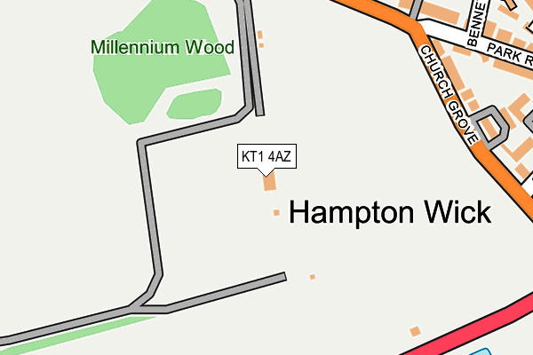
KT1 4AZ is located in the Teddington electoral ward, within the London borough of Richmond upon Thames and the English Parliamentary constituency of Twickenham. The Sub Integrated Care Board (ICB) Location is NHS South West London ICB - 36L and the police force is Metropolitan Police. This postcode has been in use since January 1980.


GetTheData
Source: OS OpenMap – Local (Ordnance Survey)
Source: OS VectorMap District (Ordnance Survey)
Licence: Open Government Licence (requires attribution)
| Easting | 517126 |
| Northing | 169457 |
| Latitude | 51.412046 |
| Longitude | -0.317240 |
GetTheData
Source: Open Postcode Geo
Licence: Open Government Licence
| Country | England |
| Postcode District | KT1 |
| ➜ KT1 open data dashboard ➜ See where KT1 is on a map ➜ Where is London? | |
GetTheData
Source: Land Registry Price Paid Data
Licence: Open Government Licence
Elevation or altitude of KT1 4AZ as distance above sea level:
| Metres | Feet | |
|---|---|---|
| Elevation | 10m | 33ft |
Elevation is measured from the approximate centre of the postcode, to the nearest point on an OS contour line from OS Terrain 50, which has contour spacing of ten vertical metres.
➜ How high above sea level am I? Find the elevation of your current position using your device's GPS.
GetTheData
Source: Open Postcode Elevation
Licence: Open Government Licence
| Ward | Teddington |
| Constituency | Twickenham |
GetTheData
Source: ONS Postcode Database
Licence: Open Government Licence
| December 2023 | Anti-social behaviour | On or near Parking Area | 321m |
| June 2023 | Violence and sexual offences | On or near Parking Area | 321m |
| May 2023 | Anti-social behaviour | On or near Parking Area | 321m |
| ➜ Get more crime data in our Crime section | |||
GetTheData
Source: data.police.uk
Licence: Open Government Licence
| Park Road Hampton Wick | Hampton Wick | 220m |
| Park Road Hampton Wick | Hampton Wick | 228m |
| Church Grove The King's Field (Hampton Court Road) | Hampton Wick | 335m |
| Church Grove The King's Field | Hampton Wick | 338m |
| Vicarage Road (Kt1) (Sandy Lane) | Hampton Wick | 344m |
| Hampton Wick Station | 0.4km |
| Kingston Station | 1.1km |
| Teddington Station | 1.8km |
GetTheData
Source: NaPTAN
Licence: Open Government Licence
GetTheData
Source: ONS Postcode Database
Licence: Open Government Licence


➜ Get more ratings from the Food Standards Agency
GetTheData
Source: Food Standards Agency
Licence: FSA terms & conditions
| Last Collection | |||
|---|---|---|---|
| Location | Mon-Fri | Sat | Distance |
| Park Road | 17:30 | 12:00 | 277m |
| Hampton Wick Railway Station | 17:30 | 12:00 | 410m |
| Hampton Wick Post Office | 17:45 | 12:00 | 425m |
GetTheData
Source: Dracos
Licence: Creative Commons Attribution-ShareAlike
| Facility | Distance |
|---|---|
| Kings Field Church Grove, Kingston Upon Thames Outdoor Tennis Courts, Grass Pitches | 346m |
| Roy's Gym (Closed) High Street, Hampton Wick, Kingston Upon Thames Health and Fitness Gym | 393m |
| St John The Baptist C Of E Junior School Lower Teddington Road, Kingston Upon Thames Grass Pitches, Sports Hall | 762m |
GetTheData
Source: Active Places
Licence: Open Government Licence
| School | Phase of Education | Distance |
|---|---|---|
| St John the Baptist Church of England Junior School Lower Teddington Road, Hampton Wick, Kingston upon Thames, KT1 4HQ | Primary | 764m |
| Hampton Wick Infant and Nursery School Normansfield Avenue, Teddington, TW11 9RP | Primary | 815m |
| Kingston University River House, 53 - 57 High Street, Surbiton Road, Kingston upon Thames, KT1 1LQ | Not applicable | 945m |
GetTheData
Source: Edubase
Licence: Open Government Licence
The below table lists the International Territorial Level (ITL) codes (formerly Nomenclature of Territorial Units for Statistics (NUTS) codes) and Local Administrative Units (LAU) codes for KT1 4AZ:
| ITL 1 Code | Name |
|---|---|
| TLI | London |
| ITL 2 Code | Name |
| TLI7 | Outer London - West and North West |
| ITL 3 Code | Name |
| TLI75 | Hounslow and Richmond upon Thames |
| LAU 1 Code | Name |
| E09000027 | Richmond upon Thames |
GetTheData
Source: ONS Postcode Directory
Licence: Open Government Licence
The below table lists the Census Output Area (OA), Lower Layer Super Output Area (LSOA), and Middle Layer Super Output Area (MSOA) for KT1 4AZ:
| Code | Name | |
|---|---|---|
| OA | E00019567 | |
| LSOA | E01003889 | Richmond upon Thames 021D |
| MSOA | E02000804 | Richmond upon Thames 021 |
GetTheData
Source: ONS Postcode Directory
Licence: Open Government Licence
| KT1 4AY | Park Road | 247m |
| KT1 4AR | Church Grove | 256m |
| KT1 4BA | Park Road | 268m |
| KT1 4AL | Church Grove | 269m |
| KT1 4AX | Park Road | 294m |
| KT1 4EG | Vineyard Row | 295m |
| KT1 4AW | Saddlers Mews | 307m |
| KT1 4AS | Park Road | 334m |
| KT1 4DF | School Lane | 348m |
| KT1 4ED | Vicarage Road | 350m |
GetTheData
Source: Open Postcode Geo; Land Registry Price Paid Data
Licence: Open Government Licence