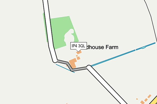
IP4 3QL is located in the St Margaret's electoral ward, within the local authority district of Ipswich and the English Parliamentary constituency of Ipswich. The Sub Integrated Care Board (ICB) Location is NHS Suffolk and North East Essex ICB - 06L and the police force is Suffolk. This postcode has been in use since January 1980.


GetTheData
Source: OS OpenMap – Local (Ordnance Survey)
Source: OS VectorMap District (Ordnance Survey)
Licence: Open Government Licence (requires attribution)
| Easting | 617457 |
| Northing | 246656 |
| Latitude | 52.075542 |
| Longitude | 1.171825 |
GetTheData
Source: Open Postcode Geo
Licence: Open Government Licence
| Country | England |
| Postcode District | IP4 |
| ➜ IP4 open data dashboard ➜ See where IP4 is on a map | |
GetTheData
Source: Land Registry Price Paid Data
Licence: Open Government Licence
Elevation or altitude of IP4 3QL as distance above sea level:
| Metres | Feet | |
|---|---|---|
| Elevation | 40m | 131ft |
Elevation is measured from the approximate centre of the postcode, to the nearest point on an OS contour line from OS Terrain 50, which has contour spacing of ten vertical metres.
➜ How high above sea level am I? Find the elevation of your current position using your device's GPS.
GetTheData
Source: Open Postcode Elevation
Licence: Open Government Licence
| Ward | St Margaret's |
| Constituency | Ipswich |
GetTheData
Source: ONS Postcode Database
Licence: Open Government Licence
| June 2022 | Violence and sexual offences | On or near Chelsworth Avenue | 481m |
| June 2022 | Violence and sexual offences | On or near Tuddenham Road | 486m |
| May 2022 | Burglary | On or near Tuddenham Road | 486m |
| ➜ Get more crime data in our Crime section | |||
GetTheData
Source: data.police.uk
Licence: Open Government Licence
| Dorset Close | Red House Farm | 335m |
| Dorset Close | Red House Farm | 349m |
| Armstrong House (Chelsworth Avenue) | Ipswich | 384m |
| Armstrong House (Chelsworth Avenue) | Ipswich | 394m |
| Bromeswell Road (Tuddenham Road) | Ipswich | 408m |
| Westerfield Station | 0.7km |
| Derby Road (Ipswich) Station | 2.9km |
| Ipswich Station | 3.4km |
GetTheData
Source: NaPTAN
Licence: Open Government Licence
GetTheData
Source: ONS Postcode Database
Licence: Open Government Licence


➜ Get more ratings from the Food Standards Agency
GetTheData
Source: Food Standards Agency
Licence: FSA terms & conditions
| Last Collection | |||
|---|---|---|---|
| Location | Mon-Fri | Sat | Distance |
| 65 Colchester Road | 17:30 | 12:00 | 714m |
| 158 Colchester Road | 17:30 | 12:00 | 718m |
| 114 Westerfield Road | 17:30 | 13:00 | 794m |
GetTheData
Source: Dracos
Licence: Creative Commons Attribution-ShareAlike
| Facility | Distance |
|---|---|
| Ipswich Sports Club Hockey Pitch Tuddenham Road, Ipswich Artificial Grass Pitch | 439m |
| Greshams Sports & Social Club Tuddenham Road, Ipswich Grass Pitches, Outdoor Tennis Courts | 563m |
| Northgate Sports Centre Sidegate Lane West, Ipswich Sports Hall, Athletics, Artificial Grass Pitch, Squash Courts, Health and Fitness Gym | 631m |
GetTheData
Source: Active Places
Licence: Open Government Licence
| School | Phase of Education | Distance |
|---|---|---|
| Northgate High School Sidegate Lane West, Ipswich, IP4 3DL | Secondary | 732m |
| Sidegate Primary School Sidegate Lane, Ipswich, IP4 4JD | Primary | 1.2km |
| Rushmere Hall Primary School Lanark Road, Rushmere Hall Primary School, Ipswich, IP4 3EJ | Primary | 1.3km |
GetTheData
Source: Edubase
Licence: Open Government Licence
The below table lists the International Territorial Level (ITL) codes (formerly Nomenclature of Territorial Units for Statistics (NUTS) codes) and Local Administrative Units (LAU) codes for IP4 3QL:
| ITL 1 Code | Name |
|---|---|
| TLH | East |
| ITL 2 Code | Name |
| TLH1 | East Anglia |
| ITL 3 Code | Name |
| TLH14 | Suffolk CC |
| LAU 1 Code | Name |
| E07000202 | Ipswich |
GetTheData
Source: ONS Postcode Directory
Licence: Open Government Licence
The below table lists the Census Output Area (OA), Lower Layer Super Output Area (LSOA), and Middle Layer Super Output Area (MSOA) for IP4 3QL:
| Code | Name | |
|---|---|---|
| OA | E00152952 | |
| LSOA | E01030011 | Ipswich 005E |
| MSOA | E02006249 | Ipswich 005 |
GetTheData
Source: ONS Postcode Directory
Licence: Open Government Licence
| IP4 3BG | Tuddenham Road | 312m |
| IP4 3AS | Bromeswell Road | 323m |
| IP4 3BE | Tuddenham Road | 336m |
| IP4 3BL | Tuddenham Road | 369m |
| IP4 3AT | Bromeswell Road | 371m |
| IP4 3AX | Chelsworth Avenue | 378m |
| IP4 3BH | Tuddenham Road | 413m |
| IP4 3AY | Chelsworth Avenue | 431m |
| IP4 3BJ | Dorset Close | 466m |
| IP4 3BT | Colchester Road | 506m |
GetTheData
Source: Open Postcode Geo; Land Registry Price Paid Data
Licence: Open Government Licence