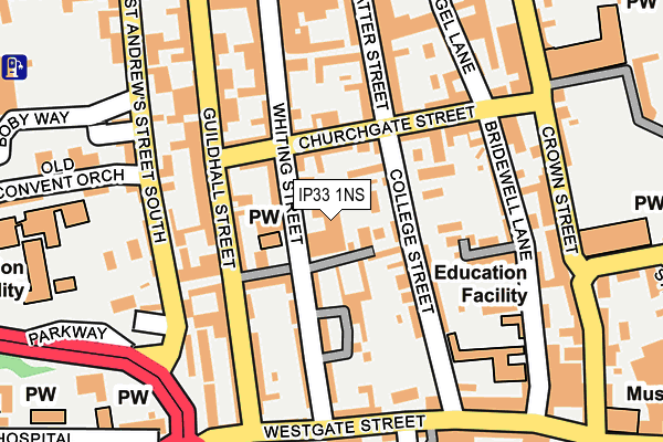
IP33 1NS is located in the Abbeygate electoral ward, within the local authority district of West Suffolk and the English Parliamentary constituency of Bury St Edmunds. The Sub Integrated Care Board (ICB) Location is NHS Suffolk and North East Essex ICB - 07K and the police force is Suffolk. This postcode has been in use since January 1980.


GetTheData
Source: OS OpenMap – Local (Ordnance Survey)
Source: OS VectorMap District (Ordnance Survey)
Licence: Open Government Licence (requires attribution)
| Easting | 585346 |
| Northing | 263979 |
| Latitude | 52.242798 |
| Longitude | 0.713340 |
GetTheData
Source: Open Postcode Geo
Licence: Open Government Licence
| Country | England |
| Postcode District | IP33 |
| ➜ IP33 open data dashboard ➜ See where IP33 is on a map ➜ Where is Bury St Edmunds? | |
GetTheData
Source: Land Registry Price Paid Data
Licence: Open Government Licence
Elevation or altitude of IP33 1NS as distance above sea level:
| Metres | Feet | |
|---|---|---|
| Elevation | 40m | 131ft |
Elevation is measured from the approximate centre of the postcode, to the nearest point on an OS contour line from OS Terrain 50, which has contour spacing of ten vertical metres.
➜ How high above sea level am I? Find the elevation of your current position using your device's GPS.
GetTheData
Source: Open Postcode Elevation
Licence: Open Government Licence
| Ward | Abbeygate |
| Constituency | Bury St Edmunds |
GetTheData
Source: ONS Postcode Database
Licence: Open Government Licence
| January 2024 | Other theft | On or near Angel Hill | 287m |
| December 2023 | Other theft | On or near Angel Hill | 287m |
| November 2023 | Bicycle theft | On or near Angel Hill | 287m |
| ➜ Get more crime data in our Crime section | |||
GetTheData
Source: data.police.uk
Licence: Open Government Licence
| School (St Andrews Street South) | Bury St Edmunds | 146m |
| School (St Andrews Street South) | Bury St Edmunds | 147m |
| St Edmunds Rc Primary (Westgate) | Bury St Edmunds | 208m |
| Chequer Square (Crown Street) | Bury St Edmunds | 218m |
| St Louis School (Parkway South) | Bury St Edmunds | 237m |
| Bury St Edmunds Station | 1.2km |
GetTheData
Source: NaPTAN
Licence: Open Government Licence
GetTheData
Source: ONS Postcode Database
Licence: Open Government Licence


➜ Get more ratings from the Food Standards Agency
GetTheData
Source: Food Standards Agency
Licence: FSA terms & conditions
| Last Collection | |||
|---|---|---|---|
| Location | Mon-Fri | Sat | Distance |
| Whiting Street | 16:30 | 11:30 | 42m |
| St. Andrews Street South | 16:45 | 11:30 | 196m |
| 2 Butter Market | 18:00 | 11:30 | 233m |
GetTheData
Source: Dracos
Licence: Creative Commons Attribution-ShareAlike
| Facility | Distance |
|---|---|
| St Louis Catholic Middle School (Closed) St. Andrews Street South, Bury St. Edmunds Sports Hall, Grass Pitches | 246m |
| The Gym Group (Bury St Edmunds) Robert Boby Way, Bury St Edmunds Health and Fitness Gym | 377m |
| Abbey Gardens Angel Hill, Bury St Edmunds Outdoor Tennis Courts | 398m |
GetTheData
Source: Active Places
Licence: Open Government Licence
| School | Phase of Education | Distance |
|---|---|---|
| Guildhall Feoffment Community Primary School Bridewell Lane, Bury St Edmunds, IP33 1RE | Primary | 215m |
| St Edmund's Catholic Primary School Westgate Street, Bury St Edmunds, IP33 1QG | Primary | 268m |
| Learning Support, Western Area Education Office New Shire Hall, Raingate Street, Bury St Edmunds, IP33 2AR | Not applicable | 612m |
GetTheData
Source: Edubase
Licence: Open Government Licence
The below table lists the International Territorial Level (ITL) codes (formerly Nomenclature of Territorial Units for Statistics (NUTS) codes) and Local Administrative Units (LAU) codes for IP33 1NS:
| ITL 1 Code | Name |
|---|---|
| TLH | East |
| ITL 2 Code | Name |
| TLH1 | East Anglia |
| ITL 3 Code | Name |
| TLH14 | Suffolk CC |
| LAU 1 Code | Name |
| E07000245 | West Suffolk |
GetTheData
Source: ONS Postcode Directory
Licence: Open Government Licence
The below table lists the Census Output Area (OA), Lower Layer Super Output Area (LSOA), and Middle Layer Super Output Area (MSOA) for IP33 1NS:
| Code | Name | |
|---|---|---|
| OA | E00153395 | |
| LSOA | E01030091 | St Edmundsbury 006A |
| MSOA | E02006278 | St Edmundsbury 006 |
GetTheData
Source: ONS Postcode Directory
Licence: Open Government Licence
| IP33 1NR | Whiting Street | 33m |
| IP33 1RH | Churchgate Street | 54m |
| IP33 1QD | Guildhall Street | 71m |
| IP33 1NH | College Street | 74m |
| IP33 1RL | Churchgate Street | 76m |
| IP33 1QE | College Lane | 82m |
| IP33 1NN | College Lane | 87m |
| IP33 1PQ | William Barnaby Yard | 118m |
| IP33 1NU | Finsbury Place | 122m |
| IP33 1NX | Whiting Street | 123m |
GetTheData
Source: Open Postcode Geo; Land Registry Price Paid Data
Licence: Open Government Licence