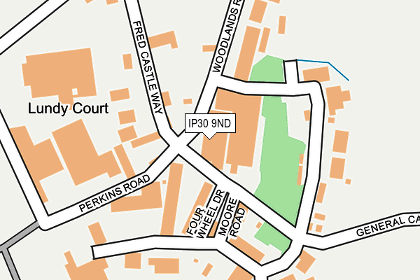
IP30 9ND lies on Rougham Industrial Estate in Rougham, Bury St Edmunds. IP30 9ND is located in the Rougham electoral ward, within the local authority district of West Suffolk and the English Parliamentary constituency of Bury St Edmunds. The Sub Integrated Care Board (ICB) Location is NHS Suffolk and North East Essex ICB - 07K and the police force is Suffolk. This postcode has been in use since October 1984.


GetTheData
Source: OS OpenMap – Local (Ordnance Survey)
Source: OS VectorMap District (Ordnance Survey)
Licence: Open Government Licence (requires attribution)
| Easting | 589582 |
| Northing | 263987 |
| Latitude | 52.241428 |
| Longitude | 0.775310 |
GetTheData
Source: Open Postcode Geo
Licence: Open Government Licence
| Street | Rougham Industrial Estate |
| Locality | Rougham |
| Town/City | Bury St Edmunds |
| Country | England |
| Postcode District | IP30 |
| ➜ IP30 open data dashboard ➜ See where IP30 is on a map | |
GetTheData
Source: Land Registry Price Paid Data
Licence: Open Government Licence
Elevation or altitude of IP30 9ND as distance above sea level:
| Metres | Feet | |
|---|---|---|
| Elevation | 60m | 197ft |
Elevation is measured from the approximate centre of the postcode, to the nearest point on an OS contour line from OS Terrain 50, which has contour spacing of ten vertical metres.
➜ How high above sea level am I? Find the elevation of your current position using your device's GPS.
GetTheData
Source: Open Postcode Elevation
Licence: Open Government Licence
| Ward | Rougham |
| Constituency | Bury St Edmunds |
GetTheData
Source: ONS Postcode Database
Licence: Open Government Licence
| June 2022 | Vehicle crime | On or near Perkins Road | 277m |
| May 2022 | Other theft | On or near Woodlands Road | 224m |
| May 2022 | Violence and sexual offences | On or near Perkins Road | 277m |
| ➜ Get more crime data in our Crime section | |||
GetTheData
Source: data.police.uk
Licence: Open Government Licence
| White House (Blackthorpe Road) | Blackthorpe | 785m |
| White House (Blackthorpe Road) | Blackthorpe | 796m |
| East Barton Road | East Barton | 800m |
| East Barton Road | East Barton | 813m |
| Sybil Andrews Academy | Moreton Hall | 1,197m |
| Thurston Station | 2.5km |
| Bury St Edmunds Station | 4.5km |
GetTheData
Source: NaPTAN
Licence: Open Government Licence
| Median download speed | 49.9Mbps |
| Average download speed | 48.5Mbps |
| Maximum download speed | 80.00Mbps |
| Median upload speed | 10.0Mbps |
| Average upload speed | 11.0Mbps |
| Maximum upload speed | 20.00Mbps |
GetTheData
Source: Ofcom
Licence: Ofcom Terms of Use (requires attribution)
GetTheData
Source: ONS Postcode Database
Licence: Open Government Licence


➜ Get more ratings from the Food Standards Agency
GetTheData
Source: Food Standards Agency
Licence: FSA terms & conditions
| Last Collection | |||
|---|---|---|---|
| Location | Mon-Fri | Sat | Distance |
| East Barton | 17:30 | 11:30 | 721m |
| Skyliner Way | 18:00 | 12:30 | 1,472m |
| Skyliner Way | 18:00 | 12:00 | 1,473m |
GetTheData
Source: Dracos
Licence: Creative Commons Attribution-ShareAlike
| Facility | Distance |
|---|---|
| Skyliner Sports Centre Rougham Tower Avenue, Bury St. Edmunds Health and Fitness Gym, Studio, Artificial Grass Pitch, Sports Hall, Outdoor Tennis Courts | 1km |
| Abbots Green Academy Airfield Road, Bury St. Edmunds Sports Hall, Grass Pitches | 1.7km |
| Sports Direct Fitness (Bury St Edmunds) (Closed) Easlea Road, Bury St. Edmunds Swimming Pool, Health and Fitness Gym, Studio | 2km |
GetTheData
Source: Active Places
Licence: Open Government Licence
| School | Phase of Education | Distance |
|---|---|---|
| Sybil Andrews Academy Rougham Tower Avenue, Bury St. Edmunds, IP32 7QB | Secondary | 1.2km |
| Sir Peter Hall School Airfield Road, Bury St. Edmunds, IP32 7PJ | Not applicable | 1.7km |
| Abbots Green Primary Academy Airfield Road, Bury St Edmunds, IP32 7PJ | Primary | 1.7km |
GetTheData
Source: Edubase
Licence: Open Government Licence
The below table lists the International Territorial Level (ITL) codes (formerly Nomenclature of Territorial Units for Statistics (NUTS) codes) and Local Administrative Units (LAU) codes for IP30 9ND:
| ITL 1 Code | Name |
|---|---|
| TLH | East |
| ITL 2 Code | Name |
| TLH1 | East Anglia |
| ITL 3 Code | Name |
| TLH14 | Suffolk CC |
| LAU 1 Code | Name |
| E07000245 | West Suffolk |
GetTheData
Source: ONS Postcode Directory
Licence: Open Government Licence
The below table lists the Census Output Area (OA), Lower Layer Super Output Area (LSOA), and Middle Layer Super Output Area (MSOA) for IP30 9ND:
| Code | Name | |
|---|---|---|
| OA | E00153654 | |
| LSOA | E01030138 | St Edmundsbury 004C |
| MSOA | E02006276 | St Edmundsbury 004 |
GetTheData
Source: ONS Postcode Directory
Licence: Open Government Licence
| IP30 9NE | Chapmans Close | 289m |
| IP30 9NF | Ipswich Road | 318m |
| IP31 2QX | 866m | |
| IP30 9JF | Kedington Close | 1107m |
| IP30 9JD | Wheelwright Close | 1134m |
| IP30 9HY | Elderstub Lane | 1159m |
| IP30 9JE | Drury Close | 1167m |
| IP30 9JB | Mouse Lane | 1209m |
| IP30 9JQ | The Downs | 1274m |
| IP32 7QA | Mortimer Road | 1277m |
GetTheData
Source: Open Postcode Geo; Land Registry Price Paid Data
Licence: Open Government Licence