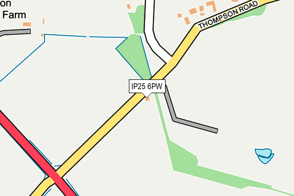
IP25 6PW is located in the All Saints & Wayland electoral ward, within the local authority district of Breckland and the English Parliamentary constituency of Mid Norfolk. The Sub Integrated Care Board (ICB) Location is NHS Norfolk and Waveney ICB - 26A and the police force is Norfolk. This postcode has been in use since January 1992.


GetTheData
Source: OS OpenMap – Local (Ordnance Survey)
Source: OS VectorMap District (Ordnance Survey)
Licence: Open Government Licence (requires attribution)
| Easting | 593833 |
| Northing | 298438 |
| Latitude | 52.549267 |
| Longitude | 0.857384 |
GetTheData
Source: Open Postcode Geo
Licence: Open Government Licence
| Country | England |
| Postcode District | IP25 |
| ➜ IP25 open data dashboard ➜ See where IP25 is on a map | |
GetTheData
Source: Land Registry Price Paid Data
Licence: Open Government Licence
Elevation or altitude of IP25 6PW as distance above sea level:
| Metres | Feet | |
|---|---|---|
| Elevation | 50m | 164ft |
Elevation is measured from the approximate centre of the postcode, to the nearest point on an OS contour line from OS Terrain 50, which has contour spacing of ten vertical metres.
➜ How high above sea level am I? Find the elevation of your current position using your device's GPS.
GetTheData
Source: Open Postcode Elevation
Licence: Open Government Licence
| Ward | All Saints & Wayland |
| Constituency | Mid Norfolk |
GetTheData
Source: ONS Postcode Database
Licence: Open Government Licence
| June 2022 | Public order | On or near Parking Area | 483m |
| June 2022 | Drugs | On or near Parking Area | 483m |
| June 2022 | Drugs | On or near Parking Area | 483m |
| ➜ Get more crime data in our Crime section | |||
GetTheData
Source: data.police.uk
Licence: Open Government Licence
| Thompson Road (A1075) | Griston | 248m |
| Thompson Road (A1075) | Griston | 253m |
| Church Road (Thompson Road) | Griston | 473m |
| Church Road (Thompson Road) | Griston | 477m |
| Church (Church Road) | Griston | 1,017m |
GetTheData
Source: NaPTAN
Licence: Open Government Licence
| Percentage of properties with Next Generation Access | 100.0% |
| Percentage of properties with Superfast Broadband | 100.0% |
| Percentage of properties with Ultrafast Broadband | 0.0% |
| Percentage of properties with Full Fibre Broadband | 0.0% |
Superfast Broadband is between 30Mbps and 300Mbps
Ultrafast Broadband is > 300Mbps
| Percentage of properties unable to receive 2Mbps | 0.0% |
| Percentage of properties unable to receive 5Mbps | 0.0% |
| Percentage of properties unable to receive 10Mbps | 0.0% |
| Percentage of properties unable to receive 30Mbps | 0.0% |
GetTheData
Source: Ofcom
Licence: Ofcom Terms of Use (requires attribution)
GetTheData
Source: ONS Postcode Database
Licence: Open Government Licence


➜ Get more ratings from the Food Standards Agency
GetTheData
Source: Food Standards Agency
Licence: FSA terms & conditions
| Last Collection | |||
|---|---|---|---|
| Location | Mon-Fri | Sat | Distance |
| Watton Road | 17:00 | 09:00 | 1,099m |
| The Nurseries Post Office | 16:15 | 09:00 | 1,720m |
| College Farm, College Farm Lan | 17:30 | 09:15 | 1,740m |
GetTheData
Source: Dracos
Licence: Creative Commons Attribution-ShareAlike
| Facility | Distance |
|---|---|
| Hmp Wayland Griston, Thetford Health and Fitness Gym, Sports Hall, Grass Pitches | 370m |
| Caston C Of E Primary Academy L The Street, Caston, Attleborough Grass Pitches, Sports Hall | 1.4km |
| Nr Health And Fitness (Watton) Norwich Road, Watton Health and Fitness Gym, Studio | 2.4km |
GetTheData
Source: Active Places
Licence: Open Government Licence
| School | Phase of Education | Distance |
|---|---|---|
| Caston Church of England Primary Academy The Street, Caston, Attleborough, NR17 1DD | Primary | 1.4km |
| Thompson Primary School School Road, Thompson, Thetford, IP24 1PY | Primary | 2.4km |
| Wayland Academy Merton Road, Watton, Thetford, IP25 6BA | Secondary | 2.9km |
GetTheData
Source: Edubase
Licence: Open Government Licence
The below table lists the International Territorial Level (ITL) codes (formerly Nomenclature of Territorial Units for Statistics (NUTS) codes) and Local Administrative Units (LAU) codes for IP25 6PW:
| ITL 1 Code | Name |
|---|---|
| TLH | East |
| ITL 2 Code | Name |
| TLH1 | East Anglia |
| ITL 3 Code | Name |
| TLH17 | Breckland and South Norfolk |
| LAU 1 Code | Name |
| E07000143 | Breckland |
GetTheData
Source: ONS Postcode Directory
Licence: Open Government Licence
The below table lists the Census Output Area (OA), Lower Layer Super Output Area (LSOA), and Middle Layer Super Output Area (MSOA) for IP25 6PW:
| Code | Name | |
|---|---|---|
| OA | E00169891 | |
| LSOA | E01033041 | Breckland 010G |
| MSOA | E02005512 | Breckland 010 |
GetTheData
Source: ONS Postcode Directory
Licence: Open Government Licence
| IP25 6RH | Thompson Road | 322m |
| IP25 6PT | Thompson Road | 338m |
| IP25 6PY | Church Road | 542m |
| IP25 6PZ | Longmeadow Close | 557m |
| IP25 6PP | The Paddocks | 628m |
| IP25 6QA | Church Road | 832m |
| IP25 6US | Church View Close | 868m |
| IP25 6RQ | Manor Road | 905m |
| IP25 6RW | Manor Road | 949m |
| IP25 6RG | Manor Road | 1055m |
GetTheData
Source: Open Postcode Geo; Land Registry Price Paid Data
Licence: Open Government Licence