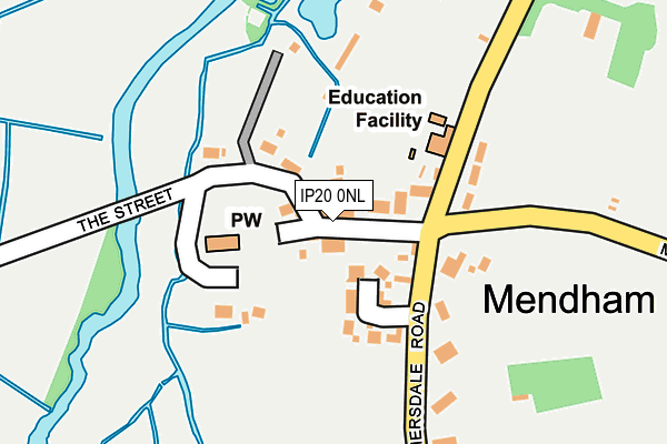
IP20 0NL is in Mendham, Harleston. IP20 0NL is located in the Fressingfield electoral ward, within the local authority district of Mid Suffolk and the English Parliamentary constituency of Central Suffolk and North Ipswich. The Sub Integrated Care Board (ICB) Location is NHS Suffolk and North East Essex ICB - 06L and the police force is Suffolk. This postcode has been in use since January 1980.


GetTheData
Source: OS OpenMap – Local (Ordnance Survey)
Source: OS VectorMap District (Ordnance Survey)
Licence: Open Government Licence (requires attribution)
| Easting | 627291 |
| Northing | 283134 |
| Latitude | 52.399014 |
| Longitude | 1.339608 |
GetTheData
Source: Open Postcode Geo
Licence: Open Government Licence
| Locality | Mendham |
| Town/City | Harleston |
| Country | England |
| Postcode District | IP20 |
➜ See where IP20 is on a map ➜ Where is Mendham? | |
GetTheData
Source: Land Registry Price Paid Data
Licence: Open Government Licence
Elevation or altitude of IP20 0NL as distance above sea level:
| Metres | Feet | |
|---|---|---|
| Elevation | 20m | 66ft |
Elevation is measured from the approximate centre of the postcode, to the nearest point on an OS contour line from OS Terrain 50, which has contour spacing of ten vertical metres.
➜ How high above sea level am I? Find the elevation of your current position using your device's GPS.
GetTheData
Source: Open Postcode Elevation
Licence: Open Government Licence
| Ward | Fressingfield |
| Constituency | Central Suffolk And North Ipswich |
GetTheData
Source: ONS Postcode Database
Licence: Open Government Licence
| Munnings Cottages (The Street) | Mendham | 263m |
| Munnings Cottages (The Street) | Mendham | 269m |
| Waveney House (Withersfield Road) | Mendham | 440m |
| Waveney House (Withersfield Road) | Mendham | 444m |
| Church (High Road) | Redenhall | 1,545m |
GetTheData
Source: NaPTAN
Licence: Open Government Licence
| Percentage of properties with Next Generation Access | 100.0% |
| Percentage of properties with Superfast Broadband | 100.0% |
| Percentage of properties with Ultrafast Broadband | 0.0% |
| Percentage of properties with Full Fibre Broadband | 0.0% |
Superfast Broadband is between 30Mbps and 300Mbps
Ultrafast Broadband is > 300Mbps
| Percentage of properties unable to receive 2Mbps | 0.0% |
| Percentage of properties unable to receive 5Mbps | 0.0% |
| Percentage of properties unable to receive 10Mbps | 0.0% |
| Percentage of properties unable to receive 30Mbps | 0.0% |
GetTheData
Source: Ofcom
Licence: Ofcom Terms of Use (requires attribution)
GetTheData
Source: ONS Postcode Database
Licence: Open Government Licence


➜ Get more ratings from the Food Standards Agency
GetTheData
Source: Food Standards Agency
Licence: FSA terms & conditions
| Last Collection | |||
|---|---|---|---|
| Location | Mon-Fri | Sat | Distance |
| Sir Alfred Munnings Hotel | 16:10 | 10:00 | 266m |
| Marsh | 16:00 | 07:00 | 949m |
| High Road | 16:45 | 11:00 | 1,766m |
GetTheData
Source: Dracos
Licence: Creative Commons Attribution-ShareAlike
| Risk of IP20 0NL flooding from rivers and sea | High |
| ➜ IP20 0NL flood map | |
GetTheData
Source: Open Flood Risk by Postcode
Licence: Open Government Licence
The below table lists the International Territorial Level (ITL) codes (formerly Nomenclature of Territorial Units for Statistics (NUTS) codes) and Local Administrative Units (LAU) codes for IP20 0NL:
| ITL 1 Code | Name |
|---|---|
| TLH | East |
| ITL 2 Code | Name |
| TLH1 | East Anglia |
| ITL 3 Code | Name |
| TLH14 | Suffolk CC |
| LAU 1 Code | Name |
| E07000203 | Mid Suffolk |
GetTheData
Source: ONS Postcode Directory
Licence: Open Government Licence
The below table lists the Census Output Area (OA), Lower Layer Super Output Area (LSOA), and Middle Layer Super Output Area (MSOA) for IP20 0NL:
| Code | Name | |
|---|---|---|
| OA | E00153168 | |
| LSOA | E01030053 | Mid Suffolk 003A |
| MSOA | E02006263 | Mid Suffolk 003 |
GetTheData
Source: ONS Postcode Directory
Licence: Open Government Licence
| IP20 0NJ | School Cottages | 150m |
| IP20 0NP | 160m | |
| IP20 0NN | Mill Lane | 280m |
| IP20 0NH | The Street | 283m |
| IP20 0JL | Street Farm Court | 308m |
| IP20 0NR | 723m | |
| IP20 0JB | Withersdale Road | 757m |
| IP20 9QU | Mendham Low Road | 760m |
| IP20 0PD | Mundys Lane | 785m |
| IP20 0HJ | Low Road | 1184m |
GetTheData
Source: Open Postcode Geo; Land Registry Price Paid Data
Licence: Open Government Licence