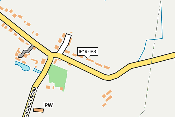
IP19 0BS lies on The Street in Cratfield, Halesworth. IP19 0BS is located in the Kelsale & Yoxford electoral ward, within the local authority district of East Suffolk and the English Parliamentary constituency of Suffolk Coastal. The Sub Integrated Care Board (ICB) Location is NHS Suffolk and North East Essex ICB - 06L and the police force is Suffolk. This postcode has been in use since January 1980.


GetTheData
Source: OS OpenMap – Local (Ordnance Survey)
Source: OS VectorMap District (Ordnance Survey)
Licence: Open Government Licence (requires attribution)
| Easting | 631556 |
| Northing | 275002 |
| Latitude | 52.324228 |
| Longitude | 1.396547 |
GetTheData
Source: Open Postcode Geo
Licence: Open Government Licence
| Street | The Street |
| Locality | Cratfield |
| Town/City | Halesworth |
| Country | England |
| Postcode District | IP19 |
| ➜ IP19 open data dashboard ➜ See where IP19 is on a map ➜ Where is Cratfield? | |
GetTheData
Source: Land Registry Price Paid Data
Licence: Open Government Licence
Elevation or altitude of IP19 0BS as distance above sea level:
| Metres | Feet | |
|---|---|---|
| Elevation | 40m | 131ft |
Elevation is measured from the approximate centre of the postcode, to the nearest point on an OS contour line from OS Terrain 50, which has contour spacing of ten vertical metres.
➜ How high above sea level am I? Find the elevation of your current position using your device's GPS.
GetTheData
Source: Open Postcode Elevation
Licence: Open Government Licence
| Ward | Kelsale & Yoxford |
| Constituency | Suffolk Coastal |
GetTheData
Source: ONS Postcode Database
Licence: Open Government Licence
| February 2021 | Violence and sexual offences | On or near The Street | 114m |
| February 2021 | Violence and sexual offences | On or near The Street | 114m |
| ➜ Get more crime data in our Crime section | |||
GetTheData
Source: data.police.uk
Licence: Open Government Licence
| Bell Green (Church Green) | Cratfield | 145m |
| Bell Green (Church Green) | Cratfield | 147m |
GetTheData
Source: NaPTAN
Licence: Open Government Licence
➜ Broadband speed and availability dashboard for IP19 0BS
| Percentage of properties with Next Generation Access | 100.0% |
| Percentage of properties with Superfast Broadband | 91.7% |
| Percentage of properties with Ultrafast Broadband | 0.0% |
| Percentage of properties with Full Fibre Broadband | 0.0% |
Superfast Broadband is between 30Mbps and 300Mbps
Ultrafast Broadband is > 300Mbps
| Median download speed | 3.4Mbps |
| Average download speed | 25.6Mbps |
| Maximum download speed | 71.24Mbps |
| Median upload speed | 0.6Mbps |
| Average upload speed | 6.6Mbps |
| Maximum upload speed | 20.00Mbps |
| Percentage of properties unable to receive 2Mbps | 0.0% |
| Percentage of properties unable to receive 5Mbps | 0.0% |
| Percentage of properties unable to receive 10Mbps | 8.3% |
| Percentage of properties unable to receive 30Mbps | 8.3% |
➜ Broadband speed and availability dashboard for IP19 0BS
GetTheData
Source: Ofcom
Licence: Ofcom Terms of Use (requires attribution)
GetTheData
Source: ONS Postcode Database
Licence: Open Government Licence

➜ Get more ratings from the Food Standards Agency
GetTheData
Source: Food Standards Agency
Licence: FSA terms & conditions
| Last Collection | |||
|---|---|---|---|
| Location | Mon-Fri | Sat | Distance |
| Halesworth Road | 16:00 | 11:00 | 3,056m |
| Laxfield | 16:00 | 09:15 | 3,250m |
| Village Pond | 16:00 | 09:15 | 3,528m |
GetTheData
Source: Dracos
Licence: Creative Commons Attribution-ShareAlike
| Facility | Distance |
|---|---|
| Laxfield Playing Field Noyes Avenue, Laxfield Grass Pitches | 3.5km |
| Hubbards Hill Recreation Ground Peasenhall, Saxmundham Grass Pitches | 6.1km |
GetTheData
Source: Active Places
Licence: Open Government Licence
| School | Phase of Education | Distance |
|---|---|---|
| All Saints Church of England Primary School, Laxfield Framlingham Road, Laxfield, Woodbridge, IP13 8HD | Primary | 3.8km |
GetTheData
Source: Edubase
Licence: Open Government Licence
The below table lists the International Territorial Level (ITL) codes (formerly Nomenclature of Territorial Units for Statistics (NUTS) codes) and Local Administrative Units (LAU) codes for IP19 0BS:
| ITL 1 Code | Name |
|---|---|
| TLH | East |
| ITL 2 Code | Name |
| TLH1 | East Anglia |
| ITL 3 Code | Name |
| TLH14 | Suffolk CC |
| LAU 1 Code | Name |
| E07000244 | East Suffolk |
GetTheData
Source: ONS Postcode Directory
Licence: Open Government Licence
The below table lists the Census Output Area (OA), Lower Layer Super Output Area (LSOA), and Middle Layer Super Output Area (MSOA) for IP19 0BS:
| Code | Name | |
|---|---|---|
| OA | E00154005 | |
| LSOA | E01030201 | Suffolk Coastal 001A |
| MSOA | E02006287 | Suffolk Coastal 001 |
GetTheData
Source: ONS Postcode Directory
Licence: Open Government Licence
| IP19 0BP | The Street | 64m |
| IP19 0BN | School Corner | 82m |
| IP19 0BW | The Street | 91m |
| IP19 0BU | Church Road | 168m |
| IP19 0BL | Bell Green | 262m |
| IP19 0BX | Huntingfield Road | 304m |
| IP19 0DH | Bell Green | 367m |
| IP19 0DL | Bell Green | 530m |
| IP19 0DJ | Manse Lane | 546m |
| IP19 0DN | Bell Green | 776m |
GetTheData
Source: Open Postcode Geo; Land Registry Price Paid Data
Licence: Open Government Licence