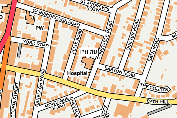
IP11 7HJ is located in the Eastern Felixstowe electoral ward, within the local authority district of East Suffolk and the English Parliamentary constituency of Suffolk Coastal. The Sub Integrated Care Board (ICB) Location is NHS Suffolk and North East Essex ICB - 06L and the police force is Suffolk. This postcode has been in use since January 1980.


GetTheData
Source: OS OpenMap – Local (Ordnance Survey)
Source: OS VectorMap District (Ordnance Survey)
Licence: Open Government Licence (requires attribution)
| Easting | 630645 |
| Northing | 234796 |
| Latitude | 51.963766 |
| Longitude | 1.355940 |
GetTheData
Source: Open Postcode Geo
Licence: Open Government Licence
| Country | England |
| Postcode District | IP11 |
| ➜ IP11 open data dashboard ➜ See where IP11 is on a map ➜ Where is Felixstowe? | |
GetTheData
Source: Land Registry Price Paid Data
Licence: Open Government Licence
Elevation or altitude of IP11 7HJ as distance above sea level:
| Metres | Feet | |
|---|---|---|
| Elevation | 20m | 66ft |
Elevation is measured from the approximate centre of the postcode, to the nearest point on an OS contour line from OS Terrain 50, which has contour spacing of ten vertical metres.
➜ How high above sea level am I? Find the elevation of your current position using your device's GPS.
GetTheData
Source: Open Postcode Elevation
Licence: Open Government Licence
| Ward | Eastern Felixstowe |
| Constituency | Suffolk Coastal |
GetTheData
Source: ONS Postcode Database
Licence: Open Government Licence
| January 2024 | Public order | On or near Parking Area | 227m |
| January 2024 | Violence and sexual offences | On or near Parking Area | 227m |
| January 2024 | Criminal damage and arson | On or near Parking Area | 461m |
| ➜ Get more crime data in our Crime section | |||
GetTheData
Source: data.police.uk
Licence: Open Government Licence
| Constable Road (Cobbold Road) | Old Felixstowe | 97m |
| Constable Road (Cobbold Road) | Old Felixstowe | 112m |
| Victoria Road (Cobbold Road) | Old Felixstowe | 230m |
| Victoria Road (Cobbold Road) | Old Felixstowe | 231m |
| Natwest Bank (Hamilton Road) | Felixstowe | 282m |
| Felixstowe Station | 0.5km |
| Trimley Station | 2.9km |
| Harwich Town Station | 5.2km |
GetTheData
Source: NaPTAN
Licence: Open Government Licence
GetTheData
Source: ONS Postcode Database
Licence: Open Government Licence


➜ Get more ratings from the Food Standards Agency
GetTheData
Source: Food Standards Agency
Licence: FSA terms & conditions
| Last Collection | |||
|---|---|---|---|
| Location | Mon-Fri | Sat | Distance |
| Bent Hill Post Office | 17:30 | 12:30 | 496m |
| 29 Foxgrove Ln | 17:15 | 12:00 | 1,422m |
| Arwela Road | 17:30 | 12:00 | 1,465m |
GetTheData
Source: Dracos
Licence: Creative Commons Attribution-ShareAlike
| Facility | Distance |
|---|---|
| Felixstowe Lawn Tennis Club Bath Road, Felixstowe Outdoor Tennis Courts | 268m |
| Coastside Fitness Cobbold Road, Felixstowe Health and Fitness Gym, Studio | 269m |
| Town Ground Dellwood Avenue, Felixstowe Grass Pitches, Outdoor Tennis Courts | 682m |
GetTheData
Source: Active Places
Licence: Open Government Licence
| School | Phase of Education | Distance |
|---|---|---|
| Fairfield Infant School High Road West, Felixstowe, IP11 9JB | Primary | 613m |
| Felixstowe International College Maybush House, Maybush Lane, Felixstowe, IP11 7NA | Not applicable | 905m |
| Colneis Junior School Colneis Road, Felixstowe, IP11 9HH | Primary | 955m |
GetTheData
Source: Edubase
Licence: Open Government Licence
The below table lists the International Territorial Level (ITL) codes (formerly Nomenclature of Territorial Units for Statistics (NUTS) codes) and Local Administrative Units (LAU) codes for IP11 7HJ:
| ITL 1 Code | Name |
|---|---|
| TLH | East |
| ITL 2 Code | Name |
| TLH1 | East Anglia |
| ITL 3 Code | Name |
| TLH14 | Suffolk CC |
| LAU 1 Code | Name |
| E07000244 | East Suffolk |
GetTheData
Source: ONS Postcode Directory
Licence: Open Government Licence
The below table lists the Census Output Area (OA), Lower Layer Super Output Area (LSOA), and Middle Layer Super Output Area (MSOA) for IP11 7HJ:
| Code | Name | |
|---|---|---|
| OA | E00153801 | |
| LSOA | E01030167 | Suffolk Coastal 015D |
| MSOA | E02006301 | Suffolk Coastal 015 |
GetTheData
Source: ONS Postcode Directory
Licence: Open Government Licence
| IP11 7JD | Felix Road | 43m |
| IP11 7HH | Constable Road | 64m |
| IP11 7HL | Constable Road | 72m |
| IP11 7JF | Cobbold Road | 74m |
| IP11 7JB | Cobbold Road | 81m |
| IP11 7HR | Gainsborough Road | 92m |
| IP11 7JH | Barton Road | 100m |
| IP11 7EH | Felix Road | 115m |
| IP11 7JA | Cobbold Road | 124m |
| IP11 7HZ | Cobbold Road | 126m |
GetTheData
Source: Open Postcode Geo; Land Registry Price Paid Data
Licence: Open Government Licence