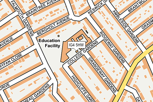
IG4 5HW is located in the Clayhall electoral ward, within the London borough of Redbridge and the English Parliamentary constituency of Ilford North. The Sub Integrated Care Board (ICB) Location is NHS North East London ICB - A3A8R and the police force is Metropolitan Police. This postcode has been in use since January 1980.


GetTheData
Source: OS OpenMap – Local (Ordnance Survey)
Source: OS VectorMap District (Ordnance Survey)
Licence: Open Government Licence (requires attribution)
| Easting | 542227 |
| Northing | 188856 |
| Latitude | 51.580627 |
| Longitude | 0.051299 |
GetTheData
Source: Open Postcode Geo
Licence: Open Government Licence
| Country | England |
| Postcode District | IG4 |
| ➜ IG4 open data dashboard ➜ See where IG4 is on a map ➜ Where is London? | |
GetTheData
Source: Land Registry Price Paid Data
Licence: Open Government Licence
Elevation or altitude of IG4 5HW as distance above sea level:
| Metres | Feet | |
|---|---|---|
| Elevation | 20m | 66ft |
Elevation is measured from the approximate centre of the postcode, to the nearest point on an OS contour line from OS Terrain 50, which has contour spacing of ten vertical metres.
➜ How high above sea level am I? Find the elevation of your current position using your device's GPS.
GetTheData
Source: Open Postcode Elevation
Licence: Open Government Licence
| Ward | Clayhall |
| Constituency | Ilford North |
GetTheData
Source: ONS Postcode Database
Licence: Open Government Licence
| June 2022 | Anti-social behaviour | On or near Grangeway Gardens | 130m |
| June 2022 | Vehicle crime | On or near Highcliffe Gardens | 164m |
| June 2022 | Other theft | On or near Tryfan Close | 260m |
| ➜ Get more crime data in our Crime section | |||
GetTheData
Source: data.police.uk
Licence: Open Government Licence
| Vista Drive (Falmouth Gardens) | Redbridge | 143m |
| Bergholt Avenue | Redbridge | 186m |
| Vista Drive | Redbridge | 286m |
| Redbridge Ln E Falmouth Gdns | Redbridge | 307m |
| Grasmere Gardens (Woodford Avenue) | Gants Hill | 447m |
| Redbridge Underground Station | Redbridge | 637m |
| Gants Hill Underground Station | Gants Hill | 1,129m |
| Ilford Station | 2.7km |
| Manor Park Station | 3.2km |
| Woodgrange Park Station | 3.5km |
GetTheData
Source: NaPTAN
Licence: Open Government Licence
GetTheData
Source: ONS Postcode Database
Licence: Open Government Licence


➜ Get more ratings from the Food Standards Agency
GetTheData
Source: Food Standards Agency
Licence: FSA terms & conditions
| Last Collection | |||
|---|---|---|---|
| Location | Mon-Fri | Sat | Distance |
| Vista Drive | 17:15 | 12:15 | 137m |
| Ridgeway | 17:00 | 12:15 | 198m |
| Keswick Road | 17:15 | 12:15 | 450m |
GetTheData
Source: Dracos
Licence: Creative Commons Attribution-ShareAlike
| Facility | Distance |
|---|---|
| Redbridge Recreation Ground Keswick Gardens, Ilford Grass Pitches | 504m |
| Beal High School Woodford Bridge Road, Ilford Grass Pitches, Sports Hall, Health and Fitness Gym, Studio | 591m |
| Redbridge Jewish Community Centre Woodford Bridge Road, Ilford Sports Hall, Artificial Grass Pitch | 596m |
GetTheData
Source: Active Places
Licence: Open Government Licence
| School | Phase of Education | Distance |
|---|---|---|
| Redbridge Primary School College Gardens, Redbridge, Ilford, IG4 5HW | Primary | 68m |
| Beehive Preparatory School 233 Beehive Lane, Redbridge, Ilford, IG4 5ED | Not applicable | 479m |
| Beal High School Woodford Bridge Road, Ilford, IG4 5LP | Secondary | 584m |
GetTheData
Source: Edubase
Licence: Open Government Licence
The below table lists the International Territorial Level (ITL) codes (formerly Nomenclature of Territorial Units for Statistics (NUTS) codes) and Local Administrative Units (LAU) codes for IG4 5HW:
| ITL 1 Code | Name |
|---|---|
| TLI | London |
| ITL 2 Code | Name |
| TLI5 | Outer London - East and North East |
| ITL 3 Code | Name |
| TLI53 | Redbridge and Waltham Forest |
| LAU 1 Code | Name |
| E09000026 | Redbridge |
GetTheData
Source: ONS Postcode Directory
Licence: Open Government Licence
The below table lists the Census Output Area (OA), Lower Layer Super Output Area (LSOA), and Middle Layer Super Output Area (MSOA) for IG4 5HW:
| Code | Name | |
|---|---|---|
| OA | E00018529 | |
| LSOA | E01003682 | Redbridge 036H |
| MSOA | E02006925 | Redbridge 036 |
GetTheData
Source: ONS Postcode Directory
Licence: Open Government Licence
| IG4 5HN | Grangeway Gardens | 106m |
| IG4 5NE | Bergholt Avenue | 122m |
| IG4 5HJ | Ridgeway Gardens | 134m |
| IG4 5HR | Highcliffe Gardens | 138m |
| IG4 5HL | Ridgeway Gardens | 139m |
| IG4 5HP | Highcliffe Gardens | 159m |
| IG4 5JG | Falmouth Gardens | 161m |
| IG4 5JQ | Falmouth Gardens | 192m |
| IG4 5ND | Keswick Gardens | 193m |
| IG4 5HH | Ambleside Gardens | 197m |
GetTheData
Source: Open Postcode Geo; Land Registry Price Paid Data
Licence: Open Government Licence