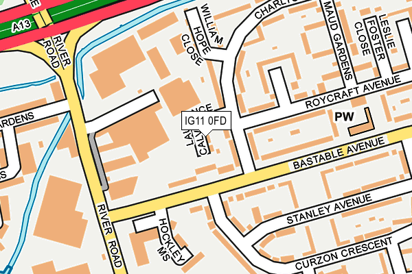
IG11 0FD is located in the Thames View electoral ward, within the London borough of Barking and Dagenham and the English Parliamentary constituency of Barking. The Sub Integrated Care Board (ICB) Location is NHS North East London ICB - A3A8R and the police force is Metropolitan Police. This postcode has been in use since September 2011.


GetTheData
Source: OS OpenMap – Local (Ordnance Survey)
Source: OS VectorMap District (Ordnance Survey)
Licence: Open Government Licence (requires attribution)
| Easting | 545514 |
| Northing | 183133 |
| Latitude | 51.528364 |
| Longitude | 0.096312 |
GetTheData
Source: Open Postcode Geo
Licence: Open Government Licence
| Country | England |
| Postcode District | IG11 |
➜ See where IG11 is on a map ➜ Where is Barking? | |
GetTheData
Source: Land Registry Price Paid Data
Licence: Open Government Licence
Elevation or altitude of IG11 0FD as distance above sea level:
| Metres | Feet | |
|---|---|---|
| Elevation | 0m | 0ft |
Elevation is measured from the approximate centre of the postcode, to the nearest point on an OS contour line from OS Terrain 50, which has contour spacing of ten vertical metres.
➜ How high above sea level am I? Find the elevation of your current position using your device's GPS.
GetTheData
Source: Open Postcode Elevation
Licence: Open Government Licence
| Ward | Thames View |
| Constituency | Barking |
GetTheData
Source: ONS Postcode Database
Licence: Open Government Licence
| Curzon Crescent | Creekmouth | 93m |
| Thames View Christ Church | Creekmouth | 143m |
| River Road Bastable Avenue | Creekmouth | 147m |
| Waverley Gardens (Ig11) (River Road) | Creekmouth | 168m |
| Waverley Gardens (Ig11) (River Road) | Creekmouth | 182m |
| Upney Underground Station | Upney | 1,170m |
| Barking Underground Station | Barking | 1,614m |
| Barking Station | 1.6km |
| Dagenham Dock Station | 3.5km |
| Ilford Station | 3.9km |
GetTheData
Source: NaPTAN
Licence: Open Government Licence
| Percentage of properties with Next Generation Access | 100.0% |
| Percentage of properties with Superfast Broadband | 100.0% |
| Percentage of properties with Ultrafast Broadband | 0.0% |
| Percentage of properties with Full Fibre Broadband | 0.0% |
Superfast Broadband is between 30Mbps and 300Mbps
Ultrafast Broadband is > 300Mbps
| Percentage of properties unable to receive 2Mbps | 0.0% |
| Percentage of properties unable to receive 5Mbps | 0.0% |
| Percentage of properties unable to receive 10Mbps | 0.0% |
| Percentage of properties unable to receive 30Mbps | 0.0% |
GetTheData
Source: Ofcom
Licence: Ofcom Terms of Use (requires attribution)
GetTheData
Source: ONS Postcode Database
Licence: Open Government Licence


➜ Get more ratings from the Food Standards Agency
GetTheData
Source: Food Standards Agency
Licence: FSA terms & conditions
| Last Collection | |||
|---|---|---|---|
| Location | Mon-Fri | Sat | Distance |
| Julia Gardens | 16:45 | 12:00 | 205m |
| Bedford Road | 17:30 | 11:30 | 339m |
| St. Johns Road | 17:00 | 12:30 | 488m |
GetTheData
Source: Dracos
Licence: Creative Commons Attribution-ShareAlike
| Risk of IG11 0FD flooding from rivers and sea | Low |
| ➜ IG11 0FD flood map | |
GetTheData
Source: Open Flood Risk by Postcode
Licence: Open Government Licence
The below table lists the International Territorial Level (ITL) codes (formerly Nomenclature of Territorial Units for Statistics (NUTS) codes) and Local Administrative Units (LAU) codes for IG11 0FD:
| ITL 1 Code | Name |
|---|---|
| TLI | London |
| ITL 2 Code | Name |
| TLI5 | Outer London - East and North East |
| ITL 3 Code | Name |
| TLI52 | Barking & Dagenham and Havering |
| LAU 1 Code | Name |
| E09000002 | Barking and Dagenham |
GetTheData
Source: ONS Postcode Directory
Licence: Open Government Licence
The below table lists the Census Output Area (OA), Lower Layer Super Output Area (LSOA), and Middle Layer Super Output Area (MSOA) for IG11 0FD:
| Code | Name | |
|---|---|---|
| OA | E00000453 | |
| LSOA | E01000092 | Barking and Dagenham 019E |
| MSOA | E02000020 | Barking and Dagenham 019 |
GetTheData
Source: ONS Postcode Directory
Licence: Open Government Licence
| IG11 0NF | Bastable Avenue | 46m |
| IG11 0JX | Bastable Avenue | 103m |
| IG11 0HE | River Road | 139m |
| IG11 0NR | Roycraft Avenue | 148m |
| IG11 0NP | Charlton Crescent | 153m |
| IG11 0LF | Bastable Avenue | 181m |
| IG11 0NG | Bastable Avenue | 189m |
| IG11 0JY | Curzon Crescent | 190m |
| IG11 0NW | Charlton Crescent | 195m |
| IG11 0LE | Stanley Avenue | 225m |
GetTheData
Source: Open Postcode Geo; Land Registry Price Paid Data
Licence: Open Government Licence