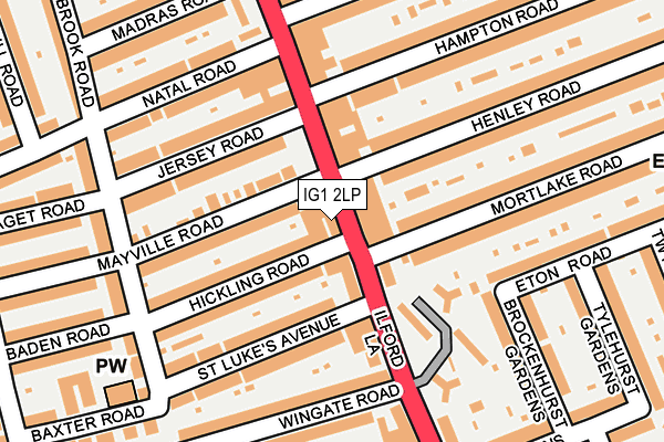
IG1 2LP is located in the Loxford electoral ward, within the London borough of Redbridge and the English Parliamentary constituency of Ilford South. The Sub Integrated Care Board (ICB) Location is NHS North East London ICB - A3A8R and the police force is Metropolitan Police. This postcode has been in use since January 1980.


GetTheData
Source: OS OpenMap – Local (Ordnance Survey)
Source: OS VectorMap District (Ordnance Survey)
Licence: Open Government Licence (requires attribution)
| Easting | 543941 |
| Northing | 185516 |
| Latitude | 51.550181 |
| Longitude | 0.074652 |
GetTheData
Source: Open Postcode Geo
Licence: Open Government Licence
| Country | England |
| Postcode District | IG1 |
| ➜ IG1 open data dashboard ➜ See where IG1 is on a map ➜ Where is Ilford? | |
GetTheData
Source: Land Registry Price Paid Data
Licence: Open Government Licence
Elevation or altitude of IG1 2LP as distance above sea level:
| Metres | Feet | |
|---|---|---|
| Elevation | 10m | 33ft |
Elevation is measured from the approximate centre of the postcode, to the nearest point on an OS contour line from OS Terrain 50, which has contour spacing of ten vertical metres.
➜ How high above sea level am I? Find the elevation of your current position using your device's GPS.
GetTheData
Source: Open Postcode Elevation
Licence: Open Government Licence
| Ward | Loxford |
| Constituency | Ilford South |
GetTheData
Source: ONS Postcode Database
Licence: Open Government Licence
| January 2024 | Anti-social behaviour | On or near Lavender Place | 436m |
| January 2024 | Anti-social behaviour | On or near Lavender Place | 436m |
| January 2024 | Anti-social behaviour | On or near Lavender Place | 436m |
| ➜ Get more crime data in our Crime section | |||
GetTheData
Source: data.police.uk
Licence: Open Government Licence
| Wingate Road | Loxford | 97m |
| Kingston Road | Ilford | 160m |
| Wingate Road | Loxford | 191m |
| Clementswood Baptist Church | Ilford | 338m |
| Loxford Polyclinic | Loxford | 401m |
| Barking Underground Station | Barking | 1,288m |
| Ilford Station | 1.1km |
| Barking Station | 1.3km |
| Manor Park Station | 2km |
GetTheData
Source: NaPTAN
Licence: Open Government Licence
GetTheData
Source: ONS Postcode Database
Licence: Open Government Licence


➜ Get more ratings from the Food Standards Agency
GetTheData
Source: Food Standards Agency
Licence: FSA terms & conditions
| Last Collection | |||
|---|---|---|---|
| Location | Mon-Fri | Sat | Distance |
| Ilford Lane | 17:30 | 12:00 | 87m |
| Hunter Road | 17:30 | 12:15 | 310m |
| Ilford Lane Post Office | 17:30 | 12:00 | 495m |
GetTheData
Source: Dracos
Licence: Creative Commons Attribution-ShareAlike
| Facility | Distance |
|---|---|
| New Physique Fitness Centre Ltd (Closed) Ilford Lane, Ilford Health and Fitness Gym | 90m |
| Loxford Park Loxford Lane, Ilford Outdoor Tennis Courts | 537m |
| Little Ilford Park Church Road, London Grass Pitches, Outdoor Tennis Courts | 604m |
GetTheData
Source: Active Places
Licence: Open Government Licence
| School | Phase of Education | Distance |
|---|---|---|
| Uphall Primary School Uphall Road, Ilford, IG1 2JD | Primary | 300m |
| Cleveland Road Primary School Cleveland Road, Ilford, IG1 1EW | Primary | 498m |
| Woodlands Primary School Loxford Lane, Ilford, IG1 2PY | Primary | 644m |
GetTheData
Source: Edubase
Licence: Open Government Licence
The below table lists the International Territorial Level (ITL) codes (formerly Nomenclature of Territorial Units for Statistics (NUTS) codes) and Local Administrative Units (LAU) codes for IG1 2LP:
| ITL 1 Code | Name |
|---|---|
| TLI | London |
| ITL 2 Code | Name |
| TLI5 | Outer London - East and North East |
| ITL 3 Code | Name |
| TLI53 | Redbridge and Waltham Forest |
| LAU 1 Code | Name |
| E09000026 | Redbridge |
GetTheData
Source: ONS Postcode Directory
Licence: Open Government Licence
The below table lists the Census Output Area (OA), Lower Layer Super Output Area (LSOA), and Middle Layer Super Output Area (MSOA) for IG1 2LP:
| Code | Name | |
|---|---|---|
| OA | E00018763 | |
| LSOA | E01003733 | Redbridge 032E |
| MSOA | E02000782 | Redbridge 032 |
GetTheData
Source: ONS Postcode Directory
Licence: Open Government Licence
| IG1 2SD | Ilford Lane | 35m |
| IG1 2LR | Ilford Lane | 46m |
| IG1 2HX | May Terrace | 67m |
| IG1 2SF | Ilford Lane | 69m |
| IG1 2SB | Ilford Lane | 98m |
| IG1 2HY | Hickling Road | 102m |
| IG1 2LT | Ilford Lane | 102m |
| IG1 2HU | Mayville Road | 103m |
| IG1 2TT | Henley Road | 118m |
| IG1 2SG | Mount Pleasant | 122m |
GetTheData
Source: Open Postcode Geo; Land Registry Price Paid Data
Licence: Open Government Licence