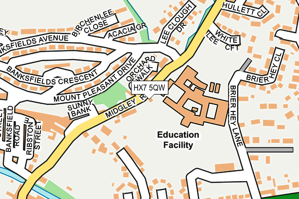
HX7 5QW is located in the Luddendenfoot electoral ward, within the metropolitan district of Calderdale and the English Parliamentary constituency of Calder Valley. The Sub Integrated Care Board (ICB) Location is NHS West Yorkshire ICB - 02T and the police force is West Yorkshire. This postcode has been in use since January 1980.


GetTheData
Source: OS OpenMap – Local (Ordnance Survey)
Source: OS VectorMap District (Ordnance Survey)
Licence: Open Government Licence (requires attribution)
| Easting | 401633 |
| Northing | 426246 |
| Latitude | 53.732605 |
| Longitude | -1.976725 |
GetTheData
Source: Open Postcode Geo
Licence: Open Government Licence
| Country | England |
| Postcode District | HX7 |
| ➜ HX7 open data dashboard ➜ See where HX7 is on a map ➜ Where is Mytholmroyd? | |
GetTheData
Source: Land Registry Price Paid Data
Licence: Open Government Licence
Elevation or altitude of HX7 5QW as distance above sea level:
| Metres | Feet | |
|---|---|---|
| Elevation | 110m | 361ft |
Elevation is measured from the approximate centre of the postcode, to the nearest point on an OS contour line from OS Terrain 50, which has contour spacing of ten vertical metres.
➜ How high above sea level am I? Find the elevation of your current position using your device's GPS.
GetTheData
Source: Open Postcode Elevation
Licence: Open Government Licence
| Ward | Luddendenfoot |
| Constituency | Calder Valley |
GetTheData
Source: ONS Postcode Database
Licence: Open Government Licence
| January 2024 | Burglary | On or near Hullett Drive | 293m |
| January 2024 | Vehicle crime | On or near Aspinall Street | 299m |
| January 2024 | Violence and sexual offences | On or near Ewood Drive | 404m |
| ➜ Get more crime data in our Crime section | |||
GetTheData
Source: data.police.uk
Licence: Open Government Licence
| Midgley Road Spring Villas (Midgley Road) | Mytholmroyd | 64m |
| Mount Pleasant Drive Banksfield Ave (Mount Pleasant Drive) | Mytholmroyd | 79m |
| Midgley Road Sunny Bank (Midgley Road) | Mytholmroyd | 103m |
| Banksfield Crescent (Bankfields Avenue) | Mytholmroyd | 114m |
| Mount Pleasant Dr Banksfield Ave (Mount Pleasant Drive) | Mytholmroyd | 192m |
| Mytholmroyd Station | 0.5km |
| Hebden Bridge Station | 2.2km |
| Sowerby Bridge Station | 5.4km |
GetTheData
Source: NaPTAN
Licence: Open Government Licence
| Percentage of properties with Next Generation Access | 100.0% |
| Percentage of properties with Superfast Broadband | 100.0% |
| Percentage of properties with Ultrafast Broadband | 0.0% |
| Percentage of properties with Full Fibre Broadband | 0.0% |
Superfast Broadband is between 30Mbps and 300Mbps
Ultrafast Broadband is > 300Mbps
| Percentage of properties unable to receive 2Mbps | 0.0% |
| Percentage of properties unable to receive 5Mbps | 0.0% |
| Percentage of properties unable to receive 10Mbps | 0.0% |
| Percentage of properties unable to receive 30Mbps | 0.0% |
GetTheData
Source: Ofcom
Licence: Ofcom Terms of Use (requires attribution)
GetTheData
Source: ONS Postcode Database
Licence: Open Government Licence


➜ Get more ratings from the Food Standards Agency
GetTheData
Source: Food Standards Agency
Licence: FSA terms & conditions
| Last Collection | |||
|---|---|---|---|
| Location | Mon-Fri | Sat | Distance |
| Mytholmroyd P.o. Box | 17:15 | 12:00 | 487m |
| Railway Station Mytholmroyd | 16:15 | 10:30 | 520m |
| 2 Cragg Road | 16:45 | 10:30 | 857m |
GetTheData
Source: Dracos
Licence: Creative Commons Attribution-ShareAlike
| Facility | Distance |
|---|---|
| The Calder High School Midgley Road, Mytholmroyd, Hebden Bridge Grass Pitches, Sports Hall, Outdoor Tennis Courts | 93m |
| White Lee Recreation Ground Burnley Road, Mytholmroyd, Hebden Bridge Grass Pitches | 206m |
| Mytholmroyd Cricket Club Moderna Way, Mytholmroyd, Hebden Bridge Grass Pitches | 517m |
GetTheData
Source: Active Places
Licence: Open Government Licence
| School | Phase of Education | Distance |
|---|---|---|
| The Calder Learning Trust Brier Hey Lane, Mytholmroyd, Hebden Bridge, HX7 5QN | All-through | 94m |
| Burnley Road Academy Burnley Road, Mytholmroyd, Hebden Bridge, HX7 5DE | Primary | 573m |
| Scout Road Academy Scout Road, Mytholmyroyd, Hebden Bridge, HX7 5JR | Primary | 617m |
GetTheData
Source: Edubase
Licence: Open Government Licence
The below table lists the International Territorial Level (ITL) codes (formerly Nomenclature of Territorial Units for Statistics (NUTS) codes) and Local Administrative Units (LAU) codes for HX7 5QW:
| ITL 1 Code | Name |
|---|---|
| TLE | Yorkshire and The Humber |
| ITL 2 Code | Name |
| TLE4 | West Yorkshire |
| ITL 3 Code | Name |
| TLE44 | Calderdale and Kirklees |
| LAU 1 Code | Name |
| E08000033 | Calderdale |
GetTheData
Source: ONS Postcode Directory
Licence: Open Government Licence
The below table lists the Census Output Area (OA), Lower Layer Super Output Area (LSOA), and Middle Layer Super Output Area (MSOA) for HX7 5QW:
| Code | Name | |
|---|---|---|
| OA | E00055057 | |
| LSOA | E01010919 | Calderdale 007C |
| MSOA | E02002250 | Calderdale 007 |
GetTheData
Source: ONS Postcode Directory
Licence: Open Government Licence
| HX7 5LZ | Spring Gardens | 37m |
| HX7 5PW | Orchard Walk | 44m |
| HX7 5NA | Spring Villas | 82m |
| HX7 5NQ | Mount Pleasant Drive | 109m |
| HX7 5PS | Laureate Place | 116m |
| HX7 5LX | Lower White Lee | 134m |
| HX7 5LS | Sunny Bank | 154m |
| HX7 5ND | Acacia Grove | 162m |
| HX7 5PP | Lee Clough Drive | 170m |
| HX7 5PE | Appleyard Road | 184m |
GetTheData
Source: Open Postcode Geo; Land Registry Price Paid Data
Licence: Open Government Licence