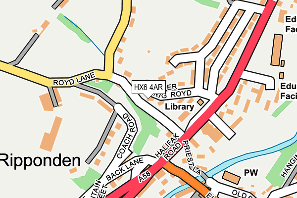
HX6 4AR is located in the Ryburn electoral ward, within the metropolitan district of Calderdale and the English Parliamentary constituency of Calder Valley. The Sub Integrated Care Board (ICB) Location is NHS West Yorkshire ICB - 02T and the police force is West Yorkshire. This postcode has been in use since January 1980.


GetTheData
Source: OS OpenMap – Local (Ordnance Survey)
Source: OS VectorMap District (Ordnance Survey)
Licence: Open Government Licence (requires attribution)
| Easting | 403952 |
| Northing | 419939 |
| Latitude | 53.675905 |
| Longitude | -1.941651 |
GetTheData
Source: Open Postcode Geo
Licence: Open Government Licence
| Country | England |
| Postcode District | HX6 |
| ➜ HX6 open data dashboard ➜ See where HX6 is on a map ➜ Where is Ripponden? | |
GetTheData
Source: Land Registry Price Paid Data
Licence: Open Government Licence
Elevation or altitude of HX6 4AR as distance above sea level:
| Metres | Feet | |
|---|---|---|
| Elevation | 150m | 492ft |
Elevation is measured from the approximate centre of the postcode, to the nearest point on an OS contour line from OS Terrain 50, which has contour spacing of ten vertical metres.
➜ How high above sea level am I? Find the elevation of your current position using your device's GPS.
GetTheData
Source: Open Postcode Elevation
Licence: Open Government Licence
| Ward | Ryburn |
| Constituency | Calder Valley |
GetTheData
Source: ONS Postcode Database
Licence: Open Government Licence
| December 2023 | Other crime | On or near Parking Area | 70m |
| June 2022 | Violence and sexual offences | On or near Back Lane | 148m |
| June 2022 | Violence and sexual offences | On or near Fountain Street | 235m |
| ➜ Get more crime data in our Crime section | |||
GetTheData
Source: data.police.uk
Licence: Open Government Licence
| Royd Lane Maude Ln (Royd Lane) | Ripponden | 38m |
| Royd Lane Maude Ln (Royd Lane) | Ripponden | 43m |
| Royd Lane Halifax Rd (Royd Lane) | Ripponden | 79m |
| Halifax Rd Royd Lane (Halifax Road) | Ripponden | 104m |
| Halifax Rd Royd Lane (Halifax Road) | Ripponden | 115m |
| Sowerby Bridge Station | 4.2km |
GetTheData
Source: NaPTAN
Licence: Open Government Licence
| Percentage of properties with Next Generation Access | 100.0% |
| Percentage of properties with Superfast Broadband | 100.0% |
| Percentage of properties with Ultrafast Broadband | 0.0% |
| Percentage of properties with Full Fibre Broadband | 0.0% |
Superfast Broadband is between 30Mbps and 300Mbps
Ultrafast Broadband is > 300Mbps
| Percentage of properties unable to receive 2Mbps | 0.0% |
| Percentage of properties unable to receive 5Mbps | 0.0% |
| Percentage of properties unable to receive 10Mbps | 0.0% |
| Percentage of properties unable to receive 30Mbps | 0.0% |
GetTheData
Source: Ofcom
Licence: Ofcom Terms of Use (requires attribution)
GetTheData
Source: ONS Postcode Database
Licence: Open Government Licence


➜ Get more ratings from the Food Standards Agency
GetTheData
Source: Food Standards Agency
Licence: FSA terms & conditions
| Last Collection | |||
|---|---|---|---|
| Location | Mon-Fri | Sat | Distance |
| Brig Royd | 17:30 | 11:30 | 135m |
| Ripponden Wood | 17:15 | 11:00 | 736m |
| Fleece Inn | 17:00 | 08:45 | 829m |
GetTheData
Source: Dracos
Licence: Creative Commons Attribution-ShareAlike
| Facility | Distance |
|---|---|
| Ripponden Woods Playing Field Ripponden Wood Lane, Ripponden, Sowerby Bridge Grass Pitches | 819m |
| Barkisland Cricket Club Scammonden Road, Barkisland, Halifax Grass Pitches | 1.4km |
| Stones Cricket Club Ripponden Old Lane, Ripponden, Sowerby Bridge Grass Pitches | 1.4km |
GetTheData
Source: Active Places
Licence: Open Government Licence
| School | Phase of Education | Distance |
|---|---|---|
| Riverbank Primary School Unit 2 Ripponden Mill, Ripponden, Halifax, HX6 4DH | Not applicable | 227m |
| Ripponden Junior and Infant School Halifax Road, Ripponden, Sowerby Bridge, HX6 4AH | Primary | 266m |
| Barkisland CofE VA Primary School Scammonden Road, Barkisland, Halifax, HX4 0BD | Primary | 1.4km |
GetTheData
Source: Edubase
Licence: Open Government Licence
The below table lists the International Territorial Level (ITL) codes (formerly Nomenclature of Territorial Units for Statistics (NUTS) codes) and Local Administrative Units (LAU) codes for HX6 4AR:
| ITL 1 Code | Name |
|---|---|
| TLE | Yorkshire and The Humber |
| ITL 2 Code | Name |
| TLE4 | West Yorkshire |
| ITL 3 Code | Name |
| TLE44 | Calderdale and Kirklees |
| LAU 1 Code | Name |
| E08000033 | Calderdale |
GetTheData
Source: ONS Postcode Directory
Licence: Open Government Licence
The below table lists the Census Output Area (OA), Lower Layer Super Output Area (LSOA), and Middle Layer Super Output Area (MSOA) for HX6 4AR:
| Code | Name | |
|---|---|---|
| OA | E00055226 | |
| LSOA | E01010952 | Calderdale 027A |
| MSOA | E02002270 | Calderdale 027 |
GetTheData
Source: ONS Postcode Directory
Licence: Open Government Licence
| HX6 4BH | Upper Brig Royd | 56m |
| HX6 4BB | Royd Park | 92m |
| HX6 4AY | Royd Lane | 116m |
| HX6 4BD | 122m | |
| HX6 4BA | Glenroyd | 127m |
| HX6 4DE | Lower Brig Royd | 133m |
| HX6 4BE | Maude Lane | 134m |
| HX6 4BG | Halifax Road | 135m |
| HX6 4BN | Hirstwood | 149m |
| HX6 4BQ | 159m |
GetTheData
Source: Open Postcode Geo; Land Registry Price Paid Data
Licence: Open Government Licence