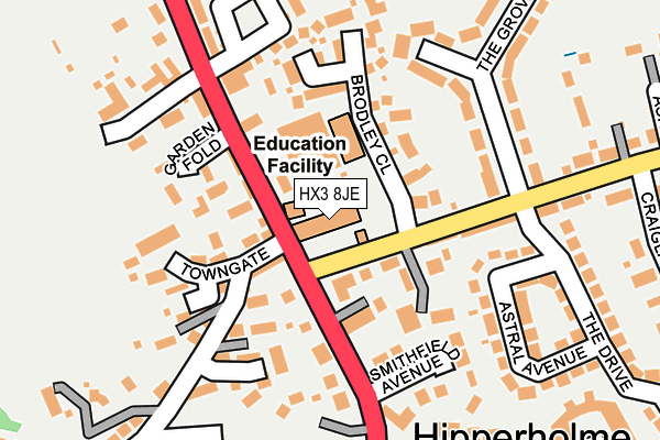
HX3 8JE is located in the Hipperholme and Lightcliffe electoral ward, within the metropolitan district of Calderdale and the English Parliamentary constituency of Calder Valley. The Sub Integrated Care Board (ICB) Location is NHS West Yorkshire ICB - 02T and the police force is West Yorkshire. This postcode has been in use since January 1980.


GetTheData
Source: OS OpenMap – Local (Ordnance Survey)
Source: OS VectorMap District (Ordnance Survey)
Licence: Open Government Licence (requires attribution)
| Easting | 412422 |
| Northing | 425804 |
| Latitude | 53.728489 |
| Longitude | -1.813201 |
GetTheData
Source: Open Postcode Geo
Licence: Open Government Licence
| Country | England |
| Postcode District | HX3 |
| ➜ HX3 open data dashboard ➜ See where HX3 is on a map ➜ Where is Brighouse? | |
GetTheData
Source: Land Registry Price Paid Data
Licence: Open Government Licence
Elevation or altitude of HX3 8JE as distance above sea level:
| Metres | Feet | |
|---|---|---|
| Elevation | 180m | 591ft |
Elevation is measured from the approximate centre of the postcode, to the nearest point on an OS contour line from OS Terrain 50, which has contour spacing of ten vertical metres.
➜ How high above sea level am I? Find the elevation of your current position using your device's GPS.
GetTheData
Source: Open Postcode Elevation
Licence: Open Government Licence
| Ward | Hipperholme And Lightcliffe |
| Constituency | Calder Valley |
GetTheData
Source: ONS Postcode Database
Licence: Open Government Licence
| October 2023 | Other theft | On or near Parking Area | 362m |
| August 2023 | Violence and sexual offences | On or near Parking Area | 362m |
| July 2023 | Criminal damage and arson | On or near Garden Fold | 129m |
| ➜ Get more crime data in our Crime section | |||
GetTheData
Source: data.police.uk
Licence: Open Government Licence
| Denholme Gate Road Towngate (Denholme Gate Road) | Hipperholme | 39m |
| Denholme Gate Road Towngate (Denholme Gate Road) | Hipperholme | 59m |
| Denholme Gate Rd Allotments (Denholme Gate Road) | Hipperholme | 227m |
| Denholme Gate Road Northedge Ln (Denholme Gate Road) | Hipperholme | 262m |
| Denholme Gate Road Northedge Ln (Denholme Gate Road) | Hipperholme | 266m |
| Halifax Station | 2.8km |
| Brighouse Station | 4km |
| Low Moor Station | 4.6km |
GetTheData
Source: NaPTAN
Licence: Open Government Licence
GetTheData
Source: ONS Postcode Database
Licence: Open Government Licence


➜ Get more ratings from the Food Standards Agency
GetTheData
Source: Food Standards Agency
Licence: FSA terms & conditions
| Last Collection | |||
|---|---|---|---|
| Location | Mon-Fri | Sat | Distance |
| Southedge Close Hipperholme | 17:30 | 12:00 | 585m |
| 22 Bramley View | 17:00 | 11:45 | 813m |
| Northowram P.o. Box | 17:00 | 12:00 | 1,635m |
GetTheData
Source: Dracos
Licence: Creative Commons Attribution-ShareAlike
| Facility | Distance |
|---|---|
| Hipperholme Grammar School Bramley Lane, Halifax Sports Hall | 0m |
| Hipperholme Grammar School Playing Fields Deneholme Gate Road, Halifax Grass Pitches | 288m |
| Woodhead Recreation Ground Denholme Gate Road, Hipperholme, Halifax Grass Pitches | 289m |
GetTheData
Source: Active Places
Licence: Open Government Licence
| School | Phase of Education | Distance |
|---|---|---|
| Hipperholme Grammar School Bramley Lane, HX3 8JE | Not applicable | 0m |
| Lightcliffe C of E Primary School Wakefield Road, Lightcliffe, Halifax, HX3 8SH | Primary | 961m |
| Lightcliffe Academy Stoney Lane, Lightcliffe, Halifax, HX3 8TL | Secondary | 1.7km |
GetTheData
Source: Edubase
Licence: Open Government Licence
The below table lists the International Territorial Level (ITL) codes (formerly Nomenclature of Territorial Units for Statistics (NUTS) codes) and Local Administrative Units (LAU) codes for HX3 8JE:
| ITL 1 Code | Name |
|---|---|
| TLE | Yorkshire and The Humber |
| ITL 2 Code | Name |
| TLE4 | West Yorkshire |
| ITL 3 Code | Name |
| TLE44 | Calderdale and Kirklees |
| LAU 1 Code | Name |
| E08000033 | Calderdale |
GetTheData
Source: ONS Postcode Directory
Licence: Open Government Licence
The below table lists the Census Output Area (OA), Lower Layer Super Output Area (LSOA), and Middle Layer Super Output Area (MSOA) for HX3 8JE:
| Code | Name | |
|---|---|---|
| OA | E00054974 | |
| LSOA | E01010907 | Calderdale 011C |
| MSOA | E02002254 | Calderdale 011 |
GetTheData
Source: ONS Postcode Directory
Licence: Open Government Licence
| HX3 8JD | 71m | |
| HX3 8JQ | Denholme Gate Road | 78m |
| HX3 8JA | Kirk Lane | 81m |
| HX3 8JH | Cobden Terrace | 92m |
| HX3 8LJ | Denholme Gate Road | 110m |
| HX3 8JJ | Bramley Lane | 113m |
| HX3 8LS | Brodley Close | 124m |
| HX3 8JB | Towngate | 129m |
| HX3 8HS | Wellcroft Gardens | 144m |
| HX3 8HU | Garden Fold | 147m |
GetTheData
Source: Open Postcode Geo; Land Registry Price Paid Data
Licence: Open Government Licence