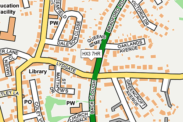
HX3 7HR is located in the Northowram and Shelf electoral ward, within the metropolitan district of Calderdale and the English Parliamentary constituency of Halifax. The Sub Integrated Care Board (ICB) Location is NHS West Yorkshire ICB - 02T and the police force is West Yorkshire. This postcode has been in use since January 1980.


GetTheData
Source: OS OpenMap – Local (Ordnance Survey)
Source: OS VectorMap District (Ordnance Survey)
Licence: Open Government Licence (requires attribution)
| Easting | 411385 |
| Northing | 427113 |
| Latitude | 53.740293 |
| Longitude | -1.828873 |
GetTheData
Source: Open Postcode Geo
Licence: Open Government Licence
| Country | England |
| Postcode District | HX3 |
| ➜ HX3 open data dashboard ➜ See where HX3 is on a map ➜ Where is Northowram? | |
GetTheData
Source: Land Registry Price Paid Data
Licence: Open Government Licence
Elevation or altitude of HX3 7HR as distance above sea level:
| Metres | Feet | |
|---|---|---|
| Elevation | 230m | 755ft |
Elevation is measured from the approximate centre of the postcode, to the nearest point on an OS contour line from OS Terrain 50, which has contour spacing of ten vertical metres.
➜ How high above sea level am I? Find the elevation of your current position using your device's GPS.
GetTheData
Source: Open Postcode Elevation
Licence: Open Government Licence
| Ward | Northowram And Shelf |
| Constituency | Halifax |
GetTheData
Source: ONS Postcode Database
Licence: Open Government Licence
| December 2023 | Burglary | On or near Upper Hall View | 385m |
| June 2023 | Public order | On or near Joseph Avenue | 319m |
| March 2023 | Violence and sexual offences | On or near Upper Hall View | 385m |
| ➜ Get more crime data in our Crime section | |||
GetTheData
Source: data.police.uk
Licence: Open Government Licence
| Westercroft Lane (Back Clough) | Northowram | 81m |
| Back Clough Westercroft Lane (Back Clough) | Northowram | 95m |
| Bradford Rd Newlands Crescent (Bradford Road) | Northowram | 118m |
| Bradford Rd Newlands Crescent (Bradford Road) | Northowram | 119m |
| Northowram Green Lydgate (Northowram Green) | Northowram | 152m |
| Halifax Station | 2.7km |
| Low Moor Station | 5.1km |
| Brighouse Station | 5.7km |
GetTheData
Source: NaPTAN
Licence: Open Government Licence
GetTheData
Source: ONS Postcode Database
Licence: Open Government Licence


➜ Get more ratings from the Food Standards Agency
GetTheData
Source: Food Standards Agency
Licence: FSA terms & conditions
| Last Collection | |||
|---|---|---|---|
| Location | Mon-Fri | Sat | Distance |
| Northowram P.o. Box | 17:00 | 12:00 | 56m |
| Southedge Close Hipperholme | 17:30 | 12:00 | 2,174m |
| 22 Bramley View | 17:00 | 11:45 | 2,241m |
GetTheData
Source: Dracos
Licence: Creative Commons Attribution-ShareAlike
| Facility | Distance |
|---|---|
| Northowram Primary School Baxter Lane, Halifax Grass Pitches | 267m |
| Northowram Community Sports & Activity Club Westercroft Lane, Halifax Grass Pitches | 290m |
| Northowram Hedge Top Cricket Club Hedge Top Lane, Halifax Grass Pitches | 336m |
GetTheData
Source: Active Places
Licence: Open Government Licence
| School | Phase of Education | Distance |
|---|---|---|
| Northowram Primary School Baxter Lane, Northowram, Halifax, HX3 7EF | Primary | 259m |
| Salterlee Primary School Kell Lane, Shibden, Halifax, HX3 7AY | Primary | 790m |
| Shelf Junior and Infant School Shelf Hall Lane, Shelf, Halifax, HX3 7LT | Primary | 1.3km |
GetTheData
Source: Edubase
Licence: Open Government Licence
The below table lists the International Territorial Level (ITL) codes (formerly Nomenclature of Territorial Units for Statistics (NUTS) codes) and Local Administrative Units (LAU) codes for HX3 7HR:
| ITL 1 Code | Name |
|---|---|
| TLE | Yorkshire and The Humber |
| ITL 2 Code | Name |
| TLE4 | West Yorkshire |
| ITL 3 Code | Name |
| TLE44 | Calderdale and Kirklees |
| LAU 1 Code | Name |
| E08000033 | Calderdale |
GetTheData
Source: ONS Postcode Directory
Licence: Open Government Licence
The below table lists the Census Output Area (OA), Lower Layer Super Output Area (LSOA), and Middle Layer Super Output Area (MSOA) for HX3 7HR:
| Code | Name | |
|---|---|---|
| OA | E00168679 | |
| LSOA | E01010936 | Calderdale 003E |
| MSOA | E02002246 | Calderdale 003 |
GetTheData
Source: ONS Postcode Directory
Licence: Open Government Licence
| HX3 7HA | Queens Mead | 29m |
| HX3 7HW | Square | 65m |
| HX3 7EJ | Lydgate | 84m |
| HX3 7JF | Daleson Close | 96m |
| HX3 7BE | Harwin Close | 112m |
| HX3 7EL | St Matthews Drive | 119m |
| HX3 7HL | St James Square | 121m |
| HX3 7HS | Oaklands Avenue | 143m |
| HX3 7HT | Newlands View | 171m |
| HX3 7EN | Westercroft Lane | 171m |
GetTheData
Source: Open Postcode Geo; Land Registry Price Paid Data
Licence: Open Government Licence