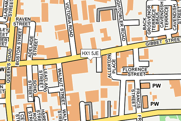
HX1 5JE is located in the Park electoral ward, within the metropolitan district of Calderdale and the English Parliamentary constituency of Halifax. The Sub Integrated Care Board (ICB) Location is NHS West Yorkshire ICB - 02T and the police force is West Yorkshire. This postcode has been in use since January 1980.


GetTheData
Source: OS OpenMap – Local (Ordnance Survey)
Source: OS VectorMap District (Ordnance Survey)
Licence: Open Government Licence (requires attribution)
| Easting | 408175 |
| Northing | 425159 |
| Latitude | 53.722790 |
| Longitude | -1.877590 |
GetTheData
Source: Open Postcode Geo
Licence: Open Government Licence
| Country | England |
| Postcode District | HX1 |
| ➜ HX1 open data dashboard ➜ See where HX1 is on a map ➜ Where is Halifax? | |
GetTheData
Source: Land Registry Price Paid Data
Licence: Open Government Licence
Elevation or altitude of HX1 5JE as distance above sea level:
| Metres | Feet | |
|---|---|---|
| Elevation | 210m | 689ft |
Elevation is measured from the approximate centre of the postcode, to the nearest point on an OS contour line from OS Terrain 50, which has contour spacing of ten vertical metres.
➜ How high above sea level am I? Find the elevation of your current position using your device's GPS.
GetTheData
Source: Open Postcode Elevation
Licence: Open Government Licence
| Ward | Park |
| Constituency | Halifax |
GetTheData
Source: ONS Postcode Database
Licence: Open Government Licence
| January 2024 | Other theft | On or near Crossley Gardens | 420m |
| January 2024 | Other theft | On or near Crossley Gardens | 420m |
| January 2024 | Public order | On or near Crossley Gardens | 420m |
| ➜ Get more crime data in our Crime section | |||
GetTheData
Source: data.police.uk
Licence: Open Government Licence
| Gibbet Street Arnold St (Gibbet Street) | King Cross | 20m |
| Gibbet Street Arnold St (Gibbet Street) | King Cross | 36m |
| Gibbet Street Francis St (Gibbet Street) | King Cross | 135m |
| Gibbet Street Adelaide St (Gibbet Street) | King Cross | 181m |
| Gibbet St Soho Street (Gibbet Street) | King Cross | 188m |
| Halifax Station | 1.6km |
| Sowerby Bridge Station | 2.6km |
GetTheData
Source: NaPTAN
Licence: Open Government Licence
GetTheData
Source: ONS Postcode Database
Licence: Open Government Licence


➜ Get more ratings from the Food Standards Agency
GetTheData
Source: Food Standards Agency
Licence: FSA terms & conditions
| Last Collection | |||
|---|---|---|---|
| Location | Mon-Fri | Sat | Distance |
| King Cross P.o. Box | 17:30 | 12:00 | 705m |
| Blackwall | 18:30 | 11:45 | 866m |
| St James Road | 18:30 | 12:00 | 945m |
GetTheData
Source: Dracos
Licence: Creative Commons Attribution-ShareAlike
| Facility | Distance |
|---|---|
| Unique Community Hub Raven Street, Halifax Grass Pitches | 232m |
| Healthy Living Gym Queens Road, Halifax Health and Fitness Gym, Studio | 312m |
| Calderdale College Francis Street, Halifax Grass Pitches, Health and Fitness Gym, Studio, Sports Hall, Artificial Grass Pitch | 418m |
GetTheData
Source: Active Places
Licence: Open Government Licence
| School | Phase of Education | Distance |
|---|---|---|
| Beacon Lights Schools Rifaiyy Building (Hopwood Lane Entrance), Francis Street, Halifax, HX1 5JY | Not applicable | 228m |
| Calderdale College Francis Street, Halifax, HX1 3UZ | 16 plus | 353m |
| St Augustine's CofE School Hanson Lane, Halifax, HX1 5PG | Primary | 366m |
GetTheData
Source: Edubase
Licence: Open Government Licence
The below table lists the International Territorial Level (ITL) codes (formerly Nomenclature of Territorial Units for Statistics (NUTS) codes) and Local Administrative Units (LAU) codes for HX1 5JE:
| ITL 1 Code | Name |
|---|---|
| TLE | Yorkshire and The Humber |
| ITL 2 Code | Name |
| TLE4 | West Yorkshire |
| ITL 3 Code | Name |
| TLE44 | Calderdale and Kirklees |
| LAU 1 Code | Name |
| E08000033 | Calderdale |
GetTheData
Source: ONS Postcode Directory
Licence: Open Government Licence
The below table lists the Census Output Area (OA), Lower Layer Super Output Area (LSOA), and Middle Layer Super Output Area (MSOA) for HX1 5JE:
| Code | Name | |
|---|---|---|
| OA | E00055280 | |
| LSOA | E01010966 | Calderdale 012D |
| MSOA | E02002255 | Calderdale 012 |
GetTheData
Source: ONS Postcode Directory
Licence: Open Government Licence
| HX1 4DB | Gibbet Street | 41m |
| HX1 5JW | Gibbet Street | 125m |
| HX1 5JX | Preston Place | 128m |
| HX1 5JB | Walnut Street | 142m |
| HX1 5JN | Francis Street | 144m |
| HX1 5JL | Craven Mount | 158m |
| HX1 4LU | Abbotts Terrace | 159m |
| HX1 5EQ | Park Terrace | 162m |
| HX1 5JT | Florence Street | 165m |
| HX1 5JS | Dombey Street | 170m |
GetTheData
Source: Open Postcode Geo; Land Registry Price Paid Data
Licence: Open Government Licence