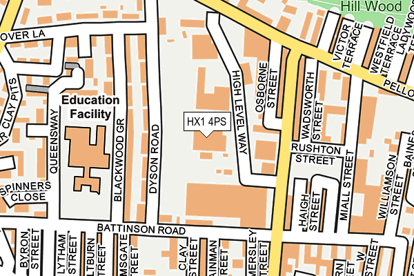
HX1 4PS is located in the Park electoral ward, within the metropolitan district of Calderdale and the English Parliamentary constituency of Halifax. The Sub Integrated Care Board (ICB) Location is NHS West Yorkshire ICB - 02T and the police force is West Yorkshire. This postcode has been in use since January 1980.


GetTheData
Source: OS OpenMap – Local (Ordnance Survey)
Source: OS VectorMap District (Ordnance Survey)
Licence: Open Government Licence (requires attribution)
| Easting | 407837 |
| Northing | 425662 |
| Latitude | 53.727301 |
| Longitude | -1.882698 |
GetTheData
Source: Open Postcode Geo
Licence: Open Government Licence
| Country | England |
| Postcode District | HX1 |
➜ See where HX1 is on a map ➜ Where is Halifax? | |
GetTheData
Source: Land Registry Price Paid Data
Licence: Open Government Licence
Elevation or altitude of HX1 4PS as distance above sea level:
| Metres | Feet | |
|---|---|---|
| Elevation | 220m | 722ft |
Elevation is measured from the approximate centre of the postcode, to the nearest point on an OS contour line from OS Terrain 50, which has contour spacing of ten vertical metres.
➜ How high above sea level am I? Find the elevation of your current position using your device's GPS.
GetTheData
Source: Open Postcode Elevation
Licence: Open Government Licence
| Ward | Park |
| Constituency | Halifax |
GetTheData
Source: ONS Postcode Database
Licence: Open Government Licence
| Pellon Ln Dyson Road (Pellon Lane) | Pellon | 197m |
| Pellon Lane Victor Ter (Pellon Lane) | Pellon | 213m |
| Pellon Lane Victor Ter (Pellon Lane) | Pellon | 229m |
| Hanson Lane Ryeburn Court (Hanson Lane) | King Cross | 231m |
| Hanson Lane Womersley St (Hanson Lane) | King Cross | 236m |
| Halifax Station | 2km |
| Sowerby Bridge Station | 2.7km |
GetTheData
Source: NaPTAN
Licence: Open Government Licence
| Percentage of properties with Next Generation Access | 100.0% |
| Percentage of properties with Superfast Broadband | 100.0% |
| Percentage of properties with Ultrafast Broadband | 0.0% |
| Percentage of properties with Full Fibre Broadband | 0.0% |
Superfast Broadband is between 30Mbps and 300Mbps
Ultrafast Broadband is > 300Mbps
| Percentage of properties unable to receive 2Mbps | 0.0% |
| Percentage of properties unable to receive 5Mbps | 0.0% |
| Percentage of properties unable to receive 10Mbps | 0.0% |
| Percentage of properties unable to receive 30Mbps | 0.0% |
GetTheData
Source: Ofcom
Licence: Ofcom Terms of Use (requires attribution)
GetTheData
Source: ONS Postcode Database
Licence: Open Government Licence

➜ Get more ratings from the Food Standards Agency
GetTheData
Source: Food Standards Agency
Licence: FSA terms & conditions
| Last Collection | |||
|---|---|---|---|
| Location | Mon-Fri | Sat | Distance |
| King Cross P.o. Box | 17:30 | 12:00 | 903m |
| St James Road | 18:30 | 12:00 | 1,294m |
| 115 Haley Hill | 17:30 | 11:45 | 1,297m |
GetTheData
Source: Dracos
Licence: Creative Commons Attribution-ShareAlike
The below table lists the International Territorial Level (ITL) codes (formerly Nomenclature of Territorial Units for Statistics (NUTS) codes) and Local Administrative Units (LAU) codes for HX1 4PS:
| ITL 1 Code | Name |
|---|---|
| TLE | Yorkshire and The Humber |
| ITL 2 Code | Name |
| TLE4 | West Yorkshire |
| ITL 3 Code | Name |
| TLE44 | Calderdale and Kirklees |
| LAU 1 Code | Name |
| E08000033 | Calderdale |
GetTheData
Source: ONS Postcode Directory
Licence: Open Government Licence
The below table lists the Census Output Area (OA), Lower Layer Super Output Area (LSOA), and Middle Layer Super Output Area (MSOA) for HX1 4PS:
| Code | Name | |
|---|---|---|
| OA | E00055266 | |
| LSOA | E01010964 | Calderdale 012B |
| MSOA | E02002255 | Calderdale 012 |
GetTheData
Source: ONS Postcode Directory
Licence: Open Government Licence
| HX1 4PR | Pellon Industrial Estate | 11m |
| HX1 4PN | High Level Way | 25m |
| HX1 4PU | Tenby Terrace | 89m |
| HX1 4PT | South View Terrace | 90m |
| HX1 4RJ | Dyson Road | 94m |
| HX1 4PY | Queens Road | 115m |
| HX1 4RH | Blackwood Grove | 118m |
| HX1 4PH | Queens Road | 142m |
| HX1 4QG | Blackwood Grove | 153m |
| HX1 4RL | Dyson Road | 155m |
GetTheData
Source: Open Postcode Geo; Land Registry Price Paid Data
Licence: Open Government Licence