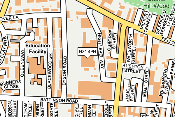
HX1 4PN lies on High Level Way in Halifax. HX1 4PN is located in the Park electoral ward, within the metropolitan district of Calderdale and the English Parliamentary constituency of Halifax. The Sub Integrated Care Board (ICB) Location is NHS West Yorkshire ICB - 02T and the police force is West Yorkshire. This postcode has been in use since May 1994.


GetTheData
Source: OS OpenMap – Local (Ordnance Survey)
Source: OS VectorMap District (Ordnance Survey)
Licence: Open Government Licence (requires attribution)
| Easting | 407840 |
| Northing | 425687 |
| Latitude | 53.727540 |
| Longitude | -1.882654 |
GetTheData
Source: Open Postcode Geo
Licence: Open Government Licence
| Street | High Level Way |
| Town/City | Halifax |
| Country | England |
| Postcode District | HX1 |
| ➜ HX1 open data dashboard ➜ See where HX1 is on a map ➜ Where is Halifax? | |
GetTheData
Source: Land Registry Price Paid Data
Licence: Open Government Licence
Elevation or altitude of HX1 4PN as distance above sea level:
| Metres | Feet | |
|---|---|---|
| Elevation | 220m | 722ft |
Elevation is measured from the approximate centre of the postcode, to the nearest point on an OS contour line from OS Terrain 50, which has contour spacing of ten vertical metres.
➜ How high above sea level am I? Find the elevation of your current position using your device's GPS.
GetTheData
Source: Open Postcode Elevation
Licence: Open Government Licence
| Ward | Park |
| Constituency | Halifax |
GetTheData
Source: ONS Postcode Database
Licence: Open Government Licence
2, HIGH LEVEL WAY, HALIFAX, HX1 4PN 1997 2 JUL £90,000 |
GetTheData
Source: HM Land Registry Price Paid Data
Licence: Contains HM Land Registry data © Crown copyright and database right 2024. This data is licensed under the Open Government Licence v3.0.
| January 2024 | Violence and sexual offences | On or near Lytham Street | 284m |
| January 2024 | Violence and sexual offences | On or near Lytham Street | 284m |
| January 2024 | Violence and sexual offences | On or near Pellon New Road | 367m |
| ➜ Get more crime data in our Crime section | |||
GetTheData
Source: data.police.uk
Licence: Open Government Licence
| Pellon Ln Dyson Road (Pellon Lane) | Pellon | 172m |
| Pellon Lane Victor Ter (Pellon Lane) | Pellon | 199m |
| Pellon Lane Victor Ter (Pellon Lane) | Pellon | 215m |
| Pellon Ln Dyson Road (Pellon Lane) | Pellon | 227m |
| Hanson Lane Ryeburn Court (Hanson Lane) | King Cross | 256m |
| Halifax Station | 2.1km |
| Sowerby Bridge Station | 2.7km |
GetTheData
Source: NaPTAN
Licence: Open Government Licence
GetTheData
Source: ONS Postcode Database
Licence: Open Government Licence
➜ Get more ratings from the Food Standards Agency
GetTheData
Source: Food Standards Agency
Licence: FSA terms & conditions
| Last Collection | |||
|---|---|---|---|
| Location | Mon-Fri | Sat | Distance |
| King Cross P.o. Box | 17:30 | 12:00 | 903m |
| 115 Haley Hill | 17:30 | 11:45 | 1,286m |
| St James Road | 18:30 | 12:00 | 1,297m |
GetTheData
Source: Dracos
Licence: Creative Commons Attribution-ShareAlike
| Facility | Distance |
|---|---|
| Unique Community Hub Raven Street, Halifax Grass Pitches | 417m |
| Healthy Living Gym Queens Road, Halifax Health and Fitness Gym, Studio | 512m |
| Shroggs Park Lee Mount Road, Halifax Grass Pitches | 679m |
GetTheData
Source: Active Places
Licence: Open Government Licence
| School | Phase of Education | Distance |
|---|---|---|
| Mount Pellon Primary Academy Battinson Road, Halifax, HX1 4RG | Primary | 187m |
| St Augustine's CofE School Hanson Lane, Halifax, HX1 5PG | Primary | 391m |
| Lee Mount Primary School Lee Mount Road, Lee Mount, Halifax, HX3 5EB | Primary | 639m |
GetTheData
Source: Edubase
Licence: Open Government Licence
The below table lists the International Territorial Level (ITL) codes (formerly Nomenclature of Territorial Units for Statistics (NUTS) codes) and Local Administrative Units (LAU) codes for HX1 4PN:
| ITL 1 Code | Name |
|---|---|
| TLE | Yorkshire and The Humber |
| ITL 2 Code | Name |
| TLE4 | West Yorkshire |
| ITL 3 Code | Name |
| TLE44 | Calderdale and Kirklees |
| LAU 1 Code | Name |
| E08000033 | Calderdale |
GetTheData
Source: ONS Postcode Directory
Licence: Open Government Licence
The below table lists the Census Output Area (OA), Lower Layer Super Output Area (LSOA), and Middle Layer Super Output Area (MSOA) for HX1 4PN:
| Code | Name | |
|---|---|---|
| OA | E00055266 | |
| LSOA | E01010964 | Calderdale 012B |
| MSOA | E02002255 | Calderdale 012 |
GetTheData
Source: ONS Postcode Directory
Licence: Open Government Licence
| HX1 4PR | Pellon Industrial Estate | 14m |
| HX1 4PU | Tenby Terrace | 77m |
| HX1 4PT | South View Terrace | 87m |
| HX1 4PY | Queens Road | 103m |
| HX1 4RJ | Dyson Road | 105m |
| HX1 4RH | Blackwood Grove | 131m |
| HX1 4PH | Queens Road | 131m |
| HX1 4RL | Dyson Road | 139m |
| HX1 4QG | Blackwood Grove | 140m |
| HX1 4PJ | Queens Road | 175m |
GetTheData
Source: Open Postcode Geo; Land Registry Price Paid Data
Licence: Open Government Licence