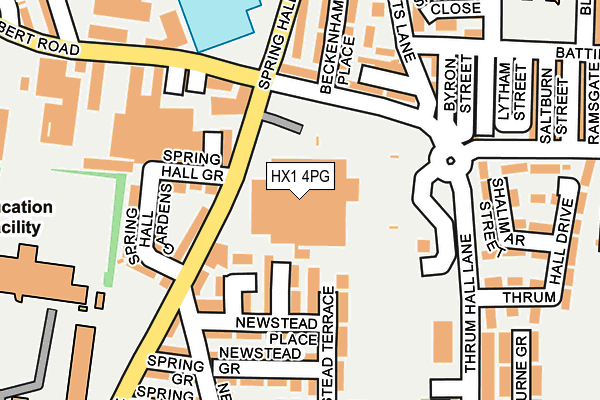
HX1 4PG is located in the Warley electoral ward, within the metropolitan district of Calderdale and the English Parliamentary constituency of Halifax. The Sub Integrated Care Board (ICB) Location is NHS West Yorkshire ICB - 02T and the police force is West Yorkshire. This postcode has been in use since September 2003.


GetTheData
Source: OS OpenMap – Local (Ordnance Survey)
Source: OS VectorMap District (Ordnance Survey)
Licence: Open Government Licence (requires attribution)
| Easting | 407422 |
| Northing | 425385 |
| Latitude | 53.724817 |
| Longitude | -1.888995 |
GetTheData
Source: Open Postcode Geo
Licence: Open Government Licence
| Country | England |
| Postcode District | HX1 |
| ➜ HX1 open data dashboard ➜ See where HX1 is on a map ➜ Where is Halifax? | |
GetTheData
Source: Land Registry Price Paid Data
Licence: Open Government Licence
Elevation or altitude of HX1 4PG as distance above sea level:
| Metres | Feet | |
|---|---|---|
| Elevation | 240m | 787ft |
Elevation is measured from the approximate centre of the postcode, to the nearest point on an OS contour line from OS Terrain 50, which has contour spacing of ten vertical metres.
➜ How high above sea level am I? Find the elevation of your current position using your device's GPS.
GetTheData
Source: Open Postcode Elevation
Licence: Open Government Licence
| Ward | Warley |
| Constituency | Halifax |
GetTheData
Source: ONS Postcode Database
Licence: Open Government Licence
| January 2024 | Other theft | On or near Newstead Heath | 118m |
| January 2024 | Violence and sexual offences | On or near Newstead Heath | 118m |
| January 2024 | Violence and sexual offences | On or near Newstead Heath | 118m |
| ➜ Get more crime data in our Crime section | |||
GetTheData
Source: data.police.uk
Licence: Open Government Licence
| Spring Hall Ln Spring Hall Grove (Spring Hall Lane) | Pellon | 64m |
| Spring Hall Lane Spring Hall Grove (Spring Hall Lane) | Pellon | 88m |
| Hanson Ln Thrum Hall Lane (Hanson Lane) | King Cross | 120m |
| Albert Road Spring Hall Ln (Albert Road) | Pellon | 133m |
| Hanson Lane Clay Pits Ln (Hanson Lane) | King Cross | 141m |
| Sowerby Bridge Station | 2.2km |
| Halifax Station | 2.4km |
GetTheData
Source: NaPTAN
Licence: Open Government Licence
GetTheData
Source: ONS Postcode Database
Licence: Open Government Licence


➜ Get more ratings from the Food Standards Agency
GetTheData
Source: Food Standards Agency
Licence: FSA terms & conditions
| Last Collection | |||
|---|---|---|---|
| Location | Mon-Fri | Sat | Distance |
| Scar Bottom P.o. Box | 17:30 | 11:45 | 1,293m |
| King Cross P.o. Box | 17:30 | 12:00 | 1,330m |
| Scarr Bottom Road | 17:15 | 11:45 | 1,458m |
GetTheData
Source: Dracos
Licence: Creative Commons Attribution-ShareAlike
| Facility | Distance |
|---|---|
| The Halifax Academy Wellesley Park, Gibbet Street, Halifax Sports Hall, Artificial Grass Pitch, Grass Pitches | 311m |
| King Cross Cricket Bowling And Athletic Club Upper Kingston, Halifax Grass Pitches | 457m |
| Healthy Living Gym Queens Road, Halifax Health and Fitness Gym, Studio | 488m |
GetTheData
Source: Active Places
Licence: Open Government Licence
| School | Phase of Education | Distance |
|---|---|---|
| The Halifax Academy Gibbet Street, Halifax, HX2 0BA | All-through | 310m |
| Mount Pellon Primary Academy Battinson Road, Halifax, HX1 4RG | Primary | 344m |
| Ling Bob Junior, Infant and Nursery School Albert Road, Pellon, Halifax, HX2 0QD | Primary | 677m |
GetTheData
Source: Edubase
Licence: Open Government Licence
The below table lists the International Territorial Level (ITL) codes (formerly Nomenclature of Territorial Units for Statistics (NUTS) codes) and Local Administrative Units (LAU) codes for HX1 4PG:
| ITL 1 Code | Name |
|---|---|
| TLE | Yorkshire and The Humber |
| ITL 2 Code | Name |
| TLE4 | West Yorkshire |
| ITL 3 Code | Name |
| TLE44 | Calderdale and Kirklees |
| LAU 1 Code | Name |
| E08000033 | Calderdale |
GetTheData
Source: ONS Postcode Directory
Licence: Open Government Licence
The below table lists the Census Output Area (OA), Lower Layer Super Output Area (LSOA), and Middle Layer Super Output Area (MSOA) for HX1 4PG:
| Code | Name | |
|---|---|---|
| OA | E00055430 | |
| LSOA | E01011000 | Calderdale 010D |
| MSOA | E02002253 | Calderdale 010 |
GetTheData
Source: ONS Postcode Directory
Licence: Open Government Licence
| HX2 0BX | Coventry Street | 93m |
| HX1 4TH | Glenholme Heath | 95m |
| HX1 4TW | Spring Hall Lane | 98m |
| HX1 4TJ | Newstead Heath | 102m |
| HX2 0BU | Spring Hall Grove | 118m |
| HX1 4QW | Hanson Lane | 127m |
| HX1 4TN | Spring Hall Lane | 134m |
| HX1 4TQ | Newstead Place | 143m |
| HX2 0BY | Albert Road | 153m |
| HX1 4TA | Newstead Terrace | 153m |
GetTheData
Source: Open Postcode Geo; Land Registry Price Paid Data
Licence: Open Government Licence