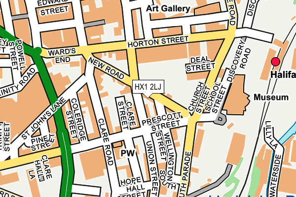
HX1 2LJ lies on Brussells Court in Halifax. HX1 2LJ is located in the Town electoral ward, within the metropolitan district of Calderdale and the English Parliamentary constituency of Halifax. The Sub Integrated Care Board (ICB) Location is NHS West Yorkshire ICB - 02T and the police force is West Yorkshire. This postcode has been in use since January 1980.


GetTheData
Source: OS OpenMap – Local (Ordnance Survey)
Source: OS VectorMap District (Ordnance Survey)
Licence: Open Government Licence (requires attribution)
| Easting | 409487 |
| Northing | 424852 |
| Latitude | 53.719993 |
| Longitude | -1.857715 |
GetTheData
Source: Open Postcode Geo
Licence: Open Government Licence
| Street | Brussells Court |
| Town/City | Halifax |
| Country | England |
| Postcode District | HX1 |
| ➜ HX1 open data dashboard ➜ See where HX1 is on a map ➜ Where is Halifax? | |
GetTheData
Source: Land Registry Price Paid Data
Licence: Open Government Licence
Elevation or altitude of HX1 2LJ as distance above sea level:
| Metres | Feet | |
|---|---|---|
| Elevation | 130m | 427ft |
Elevation is measured from the approximate centre of the postcode, to the nearest point on an OS contour line from OS Terrain 50, which has contour spacing of ten vertical metres.
➜ How high above sea level am I? Find the elevation of your current position using your device's GPS.
GetTheData
Source: Open Postcode Elevation
Licence: Open Government Licence
| Ward | Town |
| Constituency | Halifax |
GetTheData
Source: ONS Postcode Database
Licence: Open Government Licence
| January 2024 | Vehicle crime | On or near Clare Street | 97m |
| January 2024 | Vehicle crime | On or near Lilly Lane | 134m |
| January 2024 | Violence and sexual offences | On or near Church Street | 214m |
| ➜ Get more crime data in our Crime section | |||
GetTheData
Source: data.police.uk
Licence: Open Government Licence
| Union Street Hall (Union Street) | Halifax Town Centre | 21m |
| Union Street Hall (Union Street) | Halifax Town Centre | 27m |
| Church Street South Parade (Church Street) | Halifax Town Centre | 100m |
| Union Street Prescott St (Union Street) | Halifax Town Centre | 102m |
| Prescott St Clare Road (Prescott Street) | Halifax Town Centre | 105m |
| Halifax Station | 0.3km |
| Sowerby Bridge Station | 3.5km |
GetTheData
Source: NaPTAN
Licence: Open Government Licence
| Percentage of properties with Next Generation Access | 100.0% |
| Percentage of properties with Superfast Broadband | 100.0% |
| Percentage of properties with Ultrafast Broadband | 66.7% |
| Percentage of properties with Full Fibre Broadband | 0.0% |
Superfast Broadband is between 30Mbps and 300Mbps
Ultrafast Broadband is > 300Mbps
| Percentage of properties unable to receive 2Mbps | 0.0% |
| Percentage of properties unable to receive 5Mbps | 0.0% |
| Percentage of properties unable to receive 10Mbps | 0.0% |
| Percentage of properties unable to receive 30Mbps | 0.0% |
GetTheData
Source: Ofcom
Licence: Ofcom Terms of Use (requires attribution)
GetTheData
Source: ONS Postcode Database
Licence: Open Government Licence


➜ Get more ratings from the Food Standards Agency
GetTheData
Source: Food Standards Agency
Licence: FSA terms & conditions
| Last Collection | |||
|---|---|---|---|
| Location | Mon-Fri | Sat | Distance |
| 14 South Parade | 18:30 | 12:00 | 112m |
| 27 Union Street | 18:30 | 11:45 | 148m |
| 5 Wards End | 18:30 | 11:45 | 184m |
GetTheData
Source: Dracos
Licence: Creative Commons Attribution-ShareAlike
| Facility | Distance |
|---|---|
| Halifax Swimming Pool (Closed) Skircoat Road, Halifax Swimming Pool, Health and Fitness Gym, Studio, Squash Courts | 175m |
| Xplosive Fitness (Closed) Square Road, Halifax Health and Fitness Gym, Studio | 318m |
| The Halifax High School (Closed) Prescott Street, Halifax Sports Hall | 318m |
GetTheData
Source: Active Places
Licence: Open Government Licence
| School | Phase of Education | Distance |
|---|---|---|
| Trinity Sixth Form Academy Northgate House, Halifax, HX1 1UN | 16 plus | 484m |
| St Mary's Catholic Primary Academy Swires Road, Halifax, HX1 2ER | Primary | 858m |
| St Joseph's Catholic Primary Academy Portland Road, Halifax, HX3 6LA | Primary | 977m |
GetTheData
Source: Edubase
Licence: Open Government Licence
The below table lists the International Territorial Level (ITL) codes (formerly Nomenclature of Territorial Units for Statistics (NUTS) codes) and Local Administrative Units (LAU) codes for HX1 2LJ:
| ITL 1 Code | Name |
|---|---|
| TLE | Yorkshire and The Humber |
| ITL 2 Code | Name |
| TLE4 | West Yorkshire |
| ITL 3 Code | Name |
| TLE44 | Calderdale and Kirklees |
| LAU 1 Code | Name |
| E08000033 | Calderdale |
GetTheData
Source: ONS Postcode Directory
Licence: Open Government Licence
The below table lists the Census Output Area (OA), Lower Layer Super Output Area (LSOA), and Middle Layer Super Output Area (MSOA) for HX1 2LJ:
| Code | Name | |
|---|---|---|
| OA | E00055407 | |
| LSOA | E01010994 | Calderdale 008E |
| MSOA | E02002251 | Calderdale 008 |
GetTheData
Source: ONS Postcode Directory
Licence: Open Government Licence
| HX1 2LH | New Road | 7m |
| HX1 2LT | Spencers Court | 20m |
| HX1 2LL | Wellington Place | 27m |
| HX1 2LP | Brocklyn Yard | 44m |
| HX1 2JZ | New Road | 46m |
| HX1 2LN | Wellington Place | 66m |
| HX1 2LG | Prescott Street | 98m |
| HX1 2LE | Union Street South | 107m |
| HX1 2LF | Clare Street | 116m |
| HX1 1RB | South Parade | 118m |
GetTheData
Source: Open Postcode Geo; Land Registry Price Paid Data
Licence: Open Government Licence