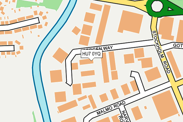
HU7 0YQ is located in the Holderness electoral ward, within the unitary authority of Kingston upon Hull, City of and the English Parliamentary constituency of Kingston upon Hull East. The Sub Integrated Care Board (ICB) Location is NHS Humber and North Yorkshire ICB - 03F and the police force is Humberside. This postcode has been in use since August 1992.


GetTheData
Source: OS OpenMap – Local (Ordnance Survey)
Source: OS VectorMap District (Ordnance Survey)
Licence: Open Government Licence (requires attribution)
| Easting | 509045 |
| Northing | 432632 |
| Latitude | 53.778629 |
| Longitude | -0.346684 |
GetTheData
Source: Open Postcode Geo
Licence: Open Government Licence
| Country | England |
| Postcode District | HU7 |
➜ See where HU7 is on a map ➜ Where is Kingston upon Hull? | |
GetTheData
Source: Land Registry Price Paid Data
Licence: Open Government Licence
Elevation or altitude of HU7 0YQ as distance above sea level:
| Metres | Feet | |
|---|---|---|
| Elevation | 0m | 0ft |
Elevation is measured from the approximate centre of the postcode, to the nearest point on an OS contour line from OS Terrain 50, which has contour spacing of ten vertical metres.
➜ How high above sea level am I? Find the elevation of your current position using your device's GPS.
GetTheData
Source: Open Postcode Elevation
Licence: Open Government Licence
| Ward | Holderness |
| Constituency | Kingston Upon Hull East |
GetTheData
Source: ONS Postcode Database
Licence: Open Government Licence
| Bergen Way (Stockholm Road) | Sutton Park | 214m |
| Ennerdale Leisure Centre (Sutton Road) | Sutton Park | 218m |
| Ennerdale Leisure Centre (Sutton Road) | Sutton Park | 225m |
| Thomas Clarkson Way (Ennerdale) | Sutton Park | 369m |
| Welwyn Park Avenue (Sutton Road) | Ghost Estate | 433m |
| Hull Station | 3.8km |
| Cottingham Station | 4km |
GetTheData
Source: NaPTAN
Licence: Open Government Licence
| Median download speed | 7.4Mbps |
| Average download speed | 146.0Mbps |
| Maximum download speed | 500.00Mbps |
| Median upload speed | 1.0Mbps |
| Average upload speed | 71.9Mbps |
| Maximum upload speed | 250.00Mbps |
GetTheData
Source: Ofcom
Licence: Ofcom Terms of Use (requires attribution)
Estimated total energy consumption in HU7 0YQ by fuel type, 2015.
| Consumption (kWh) | 161,841 |
|---|---|
| Meter count | 15 |
| Mean (kWh/meter) | 10,789 |
| Median (kWh/meter) | 1,764 |
GetTheData
Source: Postcode level gas estimates: 2015 (experimental)
Source: Postcode level electricity estimates: 2015 (experimental)
Licence: Open Government Licence
GetTheData
Source: ONS Postcode Database
Licence: Open Government Licence


➜ Get more ratings from the Food Standards Agency
GetTheData
Source: Food Standards Agency
Licence: FSA terms & conditions
| Last Collection | |||
|---|---|---|---|
| Location | Mon-Fri | Sat | Distance |
| Royal Mail Hull | 19:30 | 13:30 | 264m |
| Welwyn Park Drive Hull | 16:15 | 11:00 | 560m |
| Grandale Post Office | 16:45 | 11:15 | 604m |
GetTheData
Source: Dracos
Licence: Creative Commons Attribution-ShareAlike
| Risk of HU7 0YQ flooding from rivers and sea | Medium |
| ➜ HU7 0YQ flood map | |
GetTheData
Source: Open Flood Risk by Postcode
Licence: Open Government Licence
The below table lists the International Territorial Level (ITL) codes (formerly Nomenclature of Territorial Units for Statistics (NUTS) codes) and Local Administrative Units (LAU) codes for HU7 0YQ:
| ITL 1 Code | Name |
|---|---|
| TLE | Yorkshire and The Humber |
| ITL 2 Code | Name |
| TLE1 | East Yorkshire and Northern Lincolnshire |
| ITL 3 Code | Name |
| TLE11 | Kingston upon Hull, City of |
| LAU 1 Code | Name |
| E06000010 | Kingston upon Hull, City of |
GetTheData
Source: ONS Postcode Directory
Licence: Open Government Licence
The below table lists the Census Output Area (OA), Lower Layer Super Output Area (LSOA), and Middle Layer Super Output Area (MSOA) for HU7 0YQ:
| Code | Name | |
|---|---|---|
| OA | E00064660 | |
| LSOA | E01012817 | Kingston upon Hull 016D |
| MSOA | E02002667 | Kingston upon Hull 016 |
GetTheData
Source: ONS Postcode Directory
Licence: Open Government Licence
| HU7 0YF | Malmo Road | 137m |
| HU6 7HG | Silverdale Road | 267m |
| HU6 7DU | Elston Close | 281m |
| HU6 7HB | Riversdale Road | 286m |
| HU6 7HF | Silverdale Road | 307m |
| HU7 0YG | Gothenburg Way | 349m |
| HU6 7DW | Welwyn Park Avenue | 364m |
| HU6 7DT | Sutton Road | 378m |
| HU6 7HN | Strathmore Avenue | 389m |
| HU6 7HA | Riversdale Road | 414m |
GetTheData
Source: Open Postcode Geo; Land Registry Price Paid Data
Licence: Open Government Licence