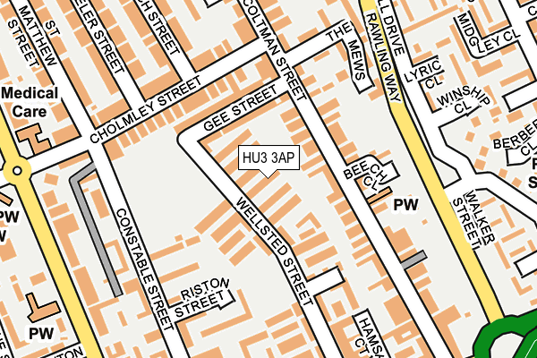
HU3 3AP lies on Albert Avenue in Hull. HU3 3AP is located in the St Andrew's & Docklands electoral ward, within the unitary authority of Kingston upon Hull, City of and the English Parliamentary constituency of Kingston upon Hull West and Hessle. The Sub Integrated Care Board (ICB) Location is NHS Humber and North Yorkshire ICB - 03F and the police force is Humberside. This postcode has been in use since January 1980.


GetTheData
Source: OS OpenMap – Local (Ordnance Survey)
Source: OS VectorMap District (Ordnance Survey)
Licence: Open Government Licence (requires attribution)
| Easting | 508196 |
| Northing | 428151 |
| Latitude | 53.738527 |
| Longitude | -0.361124 |
GetTheData
Source: Open Postcode Geo
Licence: Open Government Licence
| Street | Albert Avenue |
| Town/City | Hull |
| Country | England |
| Postcode District | HU3 |
➜ See where HU3 is on a map ➜ Where is Kingston upon Hull? | |
GetTheData
Source: Land Registry Price Paid Data
Licence: Open Government Licence
Elevation or altitude of HU3 3AP as distance above sea level:
| Metres | Feet | |
|---|---|---|
| Elevation | 0m | 0ft |
Elevation is measured from the approximate centre of the postcode, to the nearest point on an OS contour line from OS Terrain 50, which has contour spacing of ten vertical metres.
➜ How high above sea level am I? Find the elevation of your current position using your device's GPS.
GetTheData
Source: Open Postcode Elevation
Licence: Open Government Licence
| Ward | St Andrew's & Docklands |
| Constituency | Kingston Upon Hull West And Hessle |
GetTheData
Source: ONS Postcode Database
Licence: Open Government Licence
| Winship Close (Rawling Way) | Newington | 171m |
| The Mews (Rawling Way) | Newington | 200m |
| Chomley Street (Boulevard) | Newington | 260m |
| Coltman Street (Hessle Road) | St Andrews | 277m |
| Strickland Street (Hessle Road) | St Andrews | 283m |
| Hull Station | 1.2km |
| New Holland Station | 4.1km |
| Barrow Haven Station | 5km |
GetTheData
Source: NaPTAN
Licence: Open Government Licence
| Percentage of properties with Next Generation Access | 100.0% |
| Percentage of properties with Superfast Broadband | 100.0% |
| Percentage of properties with Ultrafast Broadband | 100.0% |
| Percentage of properties with Full Fibre Broadband | 100.0% |
Superfast Broadband is between 30Mbps and 300Mbps
Ultrafast Broadband is > 300Mbps
| Median download speed | 75.0Mbps |
| Average download speed | 139.0Mbps |
| Maximum download speed | 400.00Mbps |
| Median upload speed | 1.0Mbps |
| Average upload speed | 11.4Mbps |
| Maximum upload speed | 35.00Mbps |
| Percentage of properties unable to receive 2Mbps | 0.0% |
| Percentage of properties unable to receive 5Mbps | 0.0% |
| Percentage of properties unable to receive 10Mbps | 0.0% |
| Percentage of properties unable to receive 30Mbps | 0.0% |
GetTheData
Source: Ofcom
Licence: Ofcom Terms of Use (requires attribution)
Estimated total energy consumption in HU3 3AP by fuel type, 2015.
| Consumption (kWh) | 118,238 |
|---|---|
| Meter count | 16 |
| Mean (kWh/meter) | 7,390 |
| Median (kWh/meter) | 6,322 |
| Consumption (kWh) | 43,774 |
|---|---|
| Meter count | 14 |
| Mean (kWh/meter) | 3,127 |
| Median (kWh/meter) | 1,889 |
GetTheData
Source: Postcode level gas estimates: 2015 (experimental)
Source: Postcode level electricity estimates: 2015 (experimental)
Licence: Open Government Licence
GetTheData
Source: ONS Postcode Database
Licence: Open Government Licence


➜ Get more ratings from the Food Standards Agency
GetTheData
Source: Food Standards Agency
Licence: FSA terms & conditions
| Last Collection | |||
|---|---|---|---|
| Location | Mon-Fri | Sat | Distance |
| Cholmley Street | 17:00 | 12:00 | 268m |
| St Matthews Street Hull | 17:00 | 12:00 | 394m |
| Hessle Road Post Office | 17:00 | 12:45 | 463m |
GetTheData
Source: Dracos
Licence: Creative Commons Attribution-ShareAlike
| Risk of HU3 3AP flooding from rivers and sea | Low |
| ➜ HU3 3AP flood map | |
GetTheData
Source: Open Flood Risk by Postcode
Licence: Open Government Licence
The below table lists the International Territorial Level (ITL) codes (formerly Nomenclature of Territorial Units for Statistics (NUTS) codes) and Local Administrative Units (LAU) codes for HU3 3AP:
| ITL 1 Code | Name |
|---|---|
| TLE | Yorkshire and The Humber |
| ITL 2 Code | Name |
| TLE1 | East Yorkshire and Northern Lincolnshire |
| ITL 3 Code | Name |
| TLE11 | Kingston upon Hull, City of |
| LAU 1 Code | Name |
| E06000010 | Kingston upon Hull, City of |
GetTheData
Source: ONS Postcode Directory
Licence: Open Government Licence
The below table lists the Census Output Area (OA), Lower Layer Super Output Area (LSOA), and Middle Layer Super Output Area (MSOA) for HU3 3AP:
| Code | Name | |
|---|---|---|
| OA | E00065031 | |
| LSOA | E01012891 | Kingston upon Hull 030C |
| MSOA | E02002681 | Kingston upon Hull 030 |
GetTheData
Source: ONS Postcode Directory
Licence: Open Government Licence
| HU3 3AQ | Wellsted Street | 29m |
| HU3 3AW | Beech Grove | 37m |
| HU3 3AR | Victoria Avenue | 55m |
| HU3 2SF | Coltman Street | 71m |
| HU3 3AU | Cornwall Gardens | 76m |
| HU3 3AX | Thirlmere Avenue | 79m |
| HU3 3AN | Raywood Villas | 86m |
| HU3 2SL | Gee Street | 97m |
| HU3 2SW | Beech Close | 106m |
| HU3 2SJ | Coltman Street | 120m |
GetTheData
Source: Open Postcode Geo; Land Registry Price Paid Data
Licence: Open Government Licence