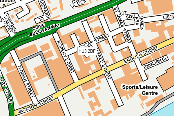
HU3 2DF is located in the St Andrew's & Docklands electoral ward, within the unitary authority of Kingston upon Hull, City of and the English Parliamentary constituency of Kingston upon Hull West and Hessle. The Sub Integrated Care Board (ICB) Location is NHS Humber and North Yorkshire ICB - 03F and the police force is Humberside. This postcode has been in use since January 1980.


GetTheData
Source: OS OpenMap – Local (Ordnance Survey)
Source: OS VectorMap District (Ordnance Survey)
Licence: Open Government Licence (requires attribution)
| Easting | 508798 |
| Northing | 427948 |
| Latitude | 53.736578 |
| Longitude | -0.352072 |
GetTheData
Source: Open Postcode Geo
Licence: Open Government Licence
| Country | England |
| Postcode District | HU3 |
➜ See where HU3 is on a map ➜ Where is Kingston upon Hull? | |
GetTheData
Source: Land Registry Price Paid Data
Licence: Open Government Licence
Elevation or altitude of HU3 2DF as distance above sea level:
| Metres | Feet | |
|---|---|---|
| Elevation | 0m | 0ft |
Elevation is measured from the approximate centre of the postcode, to the nearest point on an OS contour line from OS Terrain 50, which has contour spacing of ten vertical metres.
➜ How high above sea level am I? Find the elevation of your current position using your device's GPS.
GetTheData
Source: Open Postcode Elevation
Licence: Open Government Licence
| Ward | St Andrew's & Docklands |
| Constituency | Kingston Upon Hull West And Hessle |
GetTheData
Source: ONS Postcode Database
Licence: Open Government Licence
| Alfred Street (Jackson Street) | St Andrews | 74m |
| Tadman Street (Jackson Street) | St Andrews | 209m |
| Jackson Street | St Andrews | 221m |
| St James Street (English Street) | St Andrews | 246m |
| Redfern Close (Walker Street) | Thornton | 250m |
| Hull Station | 0.9km |
| New Holland Station | 3.9km |
| Barrow Haven Station | 5.1km |
GetTheData
Source: NaPTAN
Licence: Open Government Licence
GetTheData
Source: ONS Postcode Database
Licence: Open Government Licence


➜ Get more ratings from the Food Standards Agency
GetTheData
Source: Food Standards Agency
Licence: FSA terms & conditions
| Last Collection | |||
|---|---|---|---|
| Location | Mon-Fri | Sat | Distance |
| English Street Hull | 17:45 | 12:00 | 130m |
| Porter Street Hull | 17:30 | 12:00 | 527m |
| Kingston Street Hull | 18:30 | 12:00 | 620m |
GetTheData
Source: Dracos
Licence: Creative Commons Attribution-ShareAlike
| Risk of HU3 2DF flooding from rivers and sea | Medium |
| ➜ HU3 2DF flood map | |
GetTheData
Source: Open Flood Risk by Postcode
Licence: Open Government Licence
The below table lists the International Territorial Level (ITL) codes (formerly Nomenclature of Territorial Units for Statistics (NUTS) codes) and Local Administrative Units (LAU) codes for HU3 2DF:
| ITL 1 Code | Name |
|---|---|
| TLE | Yorkshire and The Humber |
| ITL 2 Code | Name |
| TLE1 | East Yorkshire and Northern Lincolnshire |
| ITL 3 Code | Name |
| TLE11 | Kingston upon Hull, City of |
| LAU 1 Code | Name |
| E06000010 | Kingston upon Hull, City of |
GetTheData
Source: ONS Postcode Directory
Licence: Open Government Licence
The below table lists the Census Output Area (OA), Lower Layer Super Output Area (LSOA), and Middle Layer Super Output Area (MSOA) for HU3 2DF:
| Code | Name | |
|---|---|---|
| OA | E00064823 | |
| LSOA | E01012854 | Kingston upon Hull 029C |
| MSOA | E02002680 | Kingston upon Hull 029 |
GetTheData
Source: ONS Postcode Directory
Licence: Open Government Licence
| HU3 2BU | Ropery Street | 34m |
| HU3 2BT | English Street | 95m |
| HU3 2DG | Edgar Street | 111m |
| HU3 2AA | Hessle Road | 145m |
| HU3 2BS | English Street | 156m |
| HU3 2HJ | Quantock Close | 204m |
| HU3 2HL | Neville Close | 209m |
| HU3 2RB | Redfern Close | 226m |
| HU3 2QY | Vauxhall Grove | 236m |
| HU3 2HN | Lovat Close | 260m |
GetTheData
Source: Open Postcode Geo; Land Registry Price Paid Data
Licence: Open Government Licence