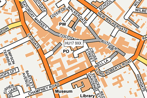
HU17 9XX is located in the St Mary's electoral ward, within the unitary authority of East Riding of Yorkshire and the English Parliamentary constituency of Beverley and Holderness. The Sub Integrated Care Board (ICB) Location is NHS Humber and North Yorkshire ICB - 02Y and the police force is Humberside. This postcode has been in use since February 1990.


GetTheData
Source: OS OpenMap – Local (Ordnance Survey)
Source: OS VectorMap District (Ordnance Survey)
Licence: Open Government Licence (requires attribution)
| Easting | 503408 |
| Northing | 439498 |
| Latitude | 53.841446 |
| Longitude | -0.429881 |
GetTheData
Source: Open Postcode Geo
Licence: Open Government Licence
| Country | England |
| Postcode District | HU17 |
| ➜ HU17 open data dashboard ➜ See where HU17 is on a map ➜ Where is Beverley? | |
GetTheData
Source: Land Registry Price Paid Data
Licence: Open Government Licence
Elevation or altitude of HU17 9XX as distance above sea level:
| Metres | Feet | |
|---|---|---|
| Elevation | 10m | 33ft |
Elevation is measured from the approximate centre of the postcode, to the nearest point on an OS contour line from OS Terrain 50, which has contour spacing of ten vertical metres.
➜ How high above sea level am I? Find the elevation of your current position using your device's GPS.
GetTheData
Source: Open Postcode Elevation
Licence: Open Government Licence
| Ward | St Mary's |
| Constituency | Beverley And Holderness |
GetTheData
Source: ONS Postcode Database
Licence: Open Government Licence
| January 2024 | Anti-social behaviour | On or near Parking Area | 162m |
| January 2024 | Burglary | On or near Parking Area | 162m |
| January 2024 | Shoplifting | On or near Parking Area | 168m |
| ➜ Get more crime data in our Crime section | |||
GetTheData
Source: data.police.uk
Licence: Open Government Licence
| Beverley Lord Roberts Rd (Lord Roberts Road) | Beverley | 203m |
| Beverley Lairgate (Lairgate) | Beverley | 203m |
| Beverley New Walkergate (New Walkergate) | Beverley | 205m |
| Beverley New Walkergate (New Walkergate) | Beverley | 228m |
| Beverley Admiral Walker Rd (Admiral Walker Road) | Beverley | 317m |
| Beverley Station | 0.5km |
| Arram Station | 4.8km |
GetTheData
Source: NaPTAN
Licence: Open Government Licence
GetTheData
Source: ONS Postcode Database
Licence: Open Government Licence


➜ Get more ratings from the Food Standards Agency
GetTheData
Source: Food Standards Agency
Licence: FSA terms & conditions
| Last Collection | |||
|---|---|---|---|
| Location | Mon-Fri | Sat | Distance |
| Market Place | 17:45 | 12:00 | 36m |
| Wednesday Market | 17:30 | 11:45 | 201m |
| Minster Yard North | 17:15 | 11:45 | 407m |
GetTheData
Source: Dracos
Licence: Creative Commons Attribution-ShareAlike
| Facility | Distance |
|---|---|
| Time Out Ladies Health Studio (Closed) Butcher Row, Beverley Health and Fitness Gym, Studio | 149m |
| Church Lads & Church Girls Brigade George Street, Beverley Sports Hall | 360m |
| Armstrongs Sports And Social Club Grovehill Road, Beverley Sports Hall | 508m |
GetTheData
Source: Active Places
Licence: Open Government Licence
| School | Phase of Education | Distance |
|---|---|---|
| Beverley Manor Nursery School Manor Road, Beverley, HU17 7BT | Nursery | 525m |
| Beverley High School Norwood, Beverley, HU17 9EX | Secondary | 581m |
| Beverley Minster Church of England Voluntary Controlled Primary School St Giles Croft, Beverley, HU17 8LA | Primary | 585m |
GetTheData
Source: Edubase
Licence: Open Government Licence
The below table lists the International Territorial Level (ITL) codes (formerly Nomenclature of Territorial Units for Statistics (NUTS) codes) and Local Administrative Units (LAU) codes for HU17 9XX:
| ITL 1 Code | Name |
|---|---|
| TLE | Yorkshire and The Humber |
| ITL 2 Code | Name |
| TLE1 | East Yorkshire and Northern Lincolnshire |
| ITL 3 Code | Name |
| TLE12 | East Riding of Yorkshire |
| LAU 1 Code | Name |
| E06000011 | East Riding of Yorkshire |
GetTheData
Source: ONS Postcode Directory
Licence: Open Government Licence
The below table lists the Census Output Area (OA), Lower Layer Super Output Area (LSOA), and Middle Layer Super Output Area (MSOA) for HU17 9XX:
| Code | Name | |
|---|---|---|
| OA | E00065937 | |
| LSOA | E01013062 | East Riding of Yorkshire 019E |
| MSOA | E02002702 | East Riding of Yorkshire 019 |
GetTheData
Source: ONS Postcode Directory
Licence: Open Government Licence
| HU17 9AR | Toll Gavel | 34m |
| HU17 9AA | Toll Gavel | 48m |
| HU17 9AX | Cross Street | 64m |
| HU17 9BN | Toll Gavel | 80m |
| HU17 9FA | Brewery House Mews | 82m |
| HU17 8HA | Landress Lane | 88m |
| HU17 9BY | Morleys Yard | 118m |
| HU17 9BT | Walkergate | 122m |
| HU17 9BP | Walkergate | 129m |
| HU17 9AW | School Lane | 137m |
GetTheData
Source: Open Postcode Geo; Land Registry Price Paid Data
Licence: Open Government Licence