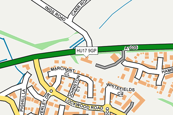
HU17 9GP is located in the St Mary's electoral ward, within the unitary authority of East Riding of Yorkshire and the English Parliamentary constituency of Beverley and Holderness. The Sub Integrated Care Board (ICB) Location is NHS Humber and North Yorkshire ICB - 02Y and the police force is Humberside. This postcode has been in use since December 1996.


GetTheData
Source: OS OpenMap – Local (Ordnance Survey)
Source: OS VectorMap District (Ordnance Survey)
Licence: Open Government Licence (requires attribution)
| Easting | 502968 |
| Northing | 441363 |
| Latitude | 53.858308 |
| Longitude | -0.435949 |
GetTheData
Source: Open Postcode Geo
Licence: Open Government Licence
| Country | England |
| Postcode District | HU17 |
| ➜ HU17 open data dashboard ➜ See where HU17 is on a map ➜ Where is Beverley? | |
GetTheData
Source: Land Registry Price Paid Data
Licence: Open Government Licence
Elevation or altitude of HU17 9GP as distance above sea level:
| Metres | Feet | |
|---|---|---|
| Elevation | 10m | 33ft |
Elevation is measured from the approximate centre of the postcode, to the nearest point on an OS contour line from OS Terrain 50, which has contour spacing of ten vertical metres.
➜ How high above sea level am I? Find the elevation of your current position using your device's GPS.
GetTheData
Source: Open Postcode Elevation
Licence: Open Government Licence
| Ward | St Mary's |
| Constituency | Beverley And Holderness |
GetTheData
Source: ONS Postcode Database
Licence: Open Government Licence
| January 2024 | Criminal damage and arson | On or near Parking Area | 436m |
| December 2023 | Violence and sexual offences | On or near Whitefields Close | 177m |
| December 2023 | Violence and sexual offences | On or near Parking Area | 436m |
| ➜ Get more crime data in our Crime section | |||
GetTheData
Source: data.police.uk
Licence: Open Government Licence
| Beverley Lockwood Road (Lockwood Road) | Beverley | 160m |
| Beverley Lockwood Road (Lockwood Road) | Beverley | 213m |
| Beverley Woodhall Way (Woodhall Way) | Beverley | 308m |
| Beverley Lockwood Road (Lockwood Road) | Beverley | 370m |
| Beverley Woodhall Way (Woodhall Way) | Beverley | 404m |
| Beverley Station | 2km |
| Arram Station | 3km |
GetTheData
Source: NaPTAN
Licence: Open Government Licence
GetTheData
Source: ONS Postcode Database
Licence: Open Government Licence


➜ Get more ratings from the Food Standards Agency
GetTheData
Source: Food Standards Agency
Licence: FSA terms & conditions
| Last Collection | |||
|---|---|---|---|
| Location | Mon-Fri | Sat | Distance |
| Lockwood Road | 16:30 | 11:30 | 292m |
| Beverley Delivery Office | 18:00 | 12:45 | 631m |
| Woodhall Way Post Office | 17:15 | 11:15 | 642m |
GetTheData
Source: Dracos
Licence: Creative Commons Attribution-ShareAlike
| Facility | Distance |
|---|---|
| Molescroft Playing Field Woodhall Way, Molescroft Grass Pitches | 349m |
| Beverley Braves Arlfc Thurlow Avenue, Molescroft Grass Pitches | 786m |
| Beaver Park (Beverley Rufc) Norwood, Beverley Grass Pitches | 1.1km |
GetTheData
Source: Active Places
Licence: Open Government Licence
| School | Phase of Education | Distance |
|---|---|---|
| Molescroft Primary School St Leonard's Road, Molescroft, Beverley, HU17 7HF | Primary | 761m |
| St Mary's Church of England Voluntary Controlled Primary School, Beverley Eden Road, Beverley, HU17 7HD | Primary | 990m |
| Longcroft School and Sixth Form College Burton Road, Beverley, HU17 7EJ | Secondary | 1.2km |
GetTheData
Source: Edubase
Licence: Open Government Licence
The below table lists the International Territorial Level (ITL) codes (formerly Nomenclature of Territorial Units for Statistics (NUTS) codes) and Local Administrative Units (LAU) codes for HU17 9GP:
| ITL 1 Code | Name |
|---|---|
| TLE | Yorkshire and The Humber |
| ITL 2 Code | Name |
| TLE1 | East Yorkshire and Northern Lincolnshire |
| ITL 3 Code | Name |
| TLE12 | East Riding of Yorkshire |
| LAU 1 Code | Name |
| E06000011 | East Riding of Yorkshire |
GetTheData
Source: ONS Postcode Directory
Licence: Open Government Licence
The below table lists the Census Output Area (OA), Lower Layer Super Output Area (LSOA), and Middle Layer Super Output Area (MSOA) for HU17 9GP:
| Code | Name | |
|---|---|---|
| OA | E00065924 | |
| LSOA | E01013064 | East Riding of Yorkshire 016A |
| MSOA | E02002699 | East Riding of Yorkshire 016 |
GetTheData
Source: ONS Postcode Directory
Licence: Open Government Licence
| HU17 9GE | Marchant Close | 91m |
| HU17 9GF | Johnston Court | 133m |
| HU17 9GY | Whitefields Close | 149m |
| HU17 7JY | Pig Hill Lane | 204m |
| HU17 9GH | Rigby Close | 207m |
| HU17 9GG | Beverley Drive | 245m |
| HU17 9GX | Lockwood Drive | 254m |
| HU17 9GD | Hambling Drive | 292m |
| HU17 7JT | Woodhall Park | 304m |
| HU17 9TA | Ascott Close | 310m |
GetTheData
Source: Open Postcode Geo; Land Registry Price Paid Data
Licence: Open Government Licence