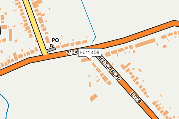
HU11 4DB is located in the Mid Holderness electoral ward, within the unitary authority of East Riding of Yorkshire and the English Parliamentary constituency of Beverley and Holderness. The Sub Integrated Care Board (ICB) Location is NHS Humber and North Yorkshire ICB - 02Y and the police force is Humberside. This postcode has been in use since January 1980.


GetTheData
Source: OS OpenMap – Local (Ordnance Survey)
Source: OS VectorMap District (Ordnance Survey)
Licence: Open Government Licence (requires attribution)
| Easting | 516660 |
| Northing | 432951 |
| Latitude | 53.779826 |
| Longitude | -0.231055 |
GetTheData
Source: Open Postcode Geo
Licence: Open Government Licence
| Country | England |
| Postcode District | HU11 |
| ➜ HU11 open data dashboard ➜ See where HU11 is on a map ➜ Where is Bilton? | |
GetTheData
Source: Land Registry Price Paid Data
Licence: Open Government Licence
Elevation or altitude of HU11 4DB as distance above sea level:
| Metres | Feet | |
|---|---|---|
| Elevation | 10m | 33ft |
Elevation is measured from the approximate centre of the postcode, to the nearest point on an OS contour line from OS Terrain 50, which has contour spacing of ten vertical metres.
➜ How high above sea level am I? Find the elevation of your current position using your device's GPS.
GetTheData
Source: Open Postcode Elevation
Licence: Open Government Licence
| Ward | Mid Holderness |
| Constituency | Beverley And Holderness |
GetTheData
Source: ONS Postcode Database
Licence: Open Government Licence
| March 2023 | Violence and sexual offences | On or near Dawnay Road | 451m |
| June 2022 | Other theft | On or near Petrol Station | 1m |
| June 2022 | Other theft | On or near Petrol Station | 1m |
| ➜ Get more crime data in our Crime section | |||
GetTheData
Source: data.police.uk
Licence: Open Government Licence
| Bilton Main Road (Main Road) | Bilton | 53m |
| Bilton Main Road (Main Road) | Bilton | 53m |
| Bilton Preston Road (Preston Road) | Bilton | 84m |
| Bilton Preston Road (Preston Road) | Bilton | 114m |
| Bilton Main Road (Main Road) | Bilton | 197m |
GetTheData
Source: NaPTAN
Licence: Open Government Licence
GetTheData
Source: ONS Postcode Database
Licence: Open Government Licence


➜ Get more ratings from the Food Standards Agency
GetTheData
Source: Food Standards Agency
Licence: FSA terms & conditions
| Last Collection | |||
|---|---|---|---|
| Location | Mon-Fri | Sat | Distance |
| Bilton Post Office | 16:15 | 10:45 | 134m |
| Wyton | 16:00 | 10:45 | 144m |
| Galfrid Road | 16:15 | 12:30 | 833m |
GetTheData
Source: Dracos
Licence: Creative Commons Attribution-ShareAlike
| Facility | Distance |
|---|---|
| Bilton Community Primary School School Lane, Bilton, Hull Grass Pitches | 1.1km |
| Bilton Memorial Playing Fields Main Road, Bilton, Hull Grass Pitches | 1.2km |
| Ganstead Park Golf Club Longdales Lane, Coniston, Hull Golf | 1.8km |
GetTheData
Source: Active Places
Licence: Open Government Licence
| School | Phase of Education | Distance |
|---|---|---|
| Bilton Community Primary School School Lane, Bilton, Hull, HU11 4EG | Primary | 1.1km |
| Wansbeck Primary School Wenning Grove, Longhill Estate, Hull, HU8 9SR | Primary | 2.1km |
| Thanet Primary School Tedworth Road, Bilton Grange, Hull, HU9 4AY | Primary | 2.1km |
GetTheData
Source: Edubase
Licence: Open Government Licence
The below table lists the International Territorial Level (ITL) codes (formerly Nomenclature of Territorial Units for Statistics (NUTS) codes) and Local Administrative Units (LAU) codes for HU11 4DB:
| ITL 1 Code | Name |
|---|---|
| TLE | Yorkshire and The Humber |
| ITL 2 Code | Name |
| TLE1 | East Yorkshire and Northern Lincolnshire |
| ITL 3 Code | Name |
| TLE12 | East Riding of Yorkshire |
| LAU 1 Code | Name |
| E06000011 | East Riding of Yorkshire |
GetTheData
Source: ONS Postcode Directory
Licence: Open Government Licence
The below table lists the Census Output Area (OA), Lower Layer Super Output Area (LSOA), and Middle Layer Super Output Area (MSOA) for HU11 4DB:
| Code | Name | |
|---|---|---|
| OA | E00065726 | |
| LSOA | E01013031 | East Riding of Yorkshire 021C |
| MSOA | E02002704 | East Riding of Yorkshire 021 |
GetTheData
Source: ONS Postcode Directory
Licence: Open Government Licence
| HU11 4DD | Preston Lane | 67m |
| HU11 4DA | Main Road | 87m |
| HU11 4DE | Preston Lane | 233m |
| HU11 4EY | Holmes Lane | 265m |
| HU11 4DH | Main Road | 268m |
| HU11 4DS | Main Road | 270m |
| HU11 4HF | Weeton Close | 282m |
| HU11 4EX | Holmes Lane | 316m |
| HU11 4HE | Ravenspur Road | 352m |
| HU11 4HH | Hungerhills Drive | 428m |
GetTheData
Source: Open Postcode Geo; Land Registry Price Paid Data
Licence: Open Government Licence