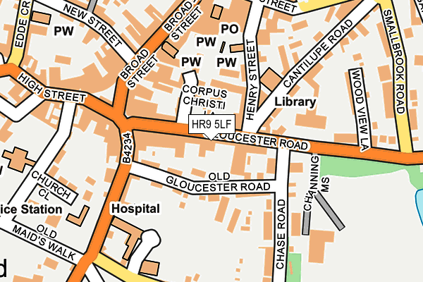
HR9 5LF is located in the Ross East electoral ward, within the unitary authority of Herefordshire, County of and the English Parliamentary constituency of Hereford and South Herefordshire. The Sub Integrated Care Board (ICB) Location is NHS Herefordshire and Worcestershire ICB - 18C and the police force is West Mercia. This postcode has been in use since January 1980.


GetTheData
Source: OS OpenMap – Local (Ordnance Survey)
Source: OS VectorMap District (Ordnance Survey)
Licence: Open Government Licence (requires attribution)
| Easting | 360071 |
| Northing | 224073 |
| Latitude | 51.913754 |
| Longitude | -2.581906 |
GetTheData
Source: Open Postcode Geo
Licence: Open Government Licence
| Country | England |
| Postcode District | HR9 |
| ➜ HR9 open data dashboard ➜ See where HR9 is on a map ➜ Where is Ross-on-Wye? | |
GetTheData
Source: Land Registry Price Paid Data
Licence: Open Government Licence
Elevation or altitude of HR9 5LF as distance above sea level:
| Metres | Feet | |
|---|---|---|
| Elevation | 40m | 131ft |
Elevation is measured from the approximate centre of the postcode, to the nearest point on an OS contour line from OS Terrain 50, which has contour spacing of ten vertical metres.
➜ How high above sea level am I? Find the elevation of your current position using your device's GPS.
GetTheData
Source: Open Postcode Elevation
Licence: Open Government Licence
| Ward | Ross East |
| Constituency | Hereford And South Herefordshire |
GetTheData
Source: ONS Postcode Database
Licence: Open Government Licence
| January 2024 | Burglary | On or near Hill Street | 68m |
| January 2024 | Drugs | On or near Parking Area | 329m |
| December 2023 | Criminal damage and arson | On or near Parking Area | 271m |
| ➜ Get more crime data in our Crime section | |||
GetTheData
Source: data.police.uk
Licence: Open Government Licence
| Cantilupe Road | Ross-on-wye | 94m |
| Cantilupe Road | Ross-on-wye | 121m |
| Cantilupe Road | Ross-on-wye | 157m |
| Cantilupe Road | Ross-on-wye | 180m |
| St Frances Church (Copse Cross Street) | Ross-on-wye | 242m |
GetTheData
Source: NaPTAN
Licence: Open Government Licence
GetTheData
Source: ONS Postcode Database
Licence: Open Government Licence


➜ Get more ratings from the Food Standards Agency
GetTheData
Source: Food Standards Agency
Licence: FSA terms & conditions
| Last Collection | |||
|---|---|---|---|
| Location | Mon-Fri | Sat | Distance |
| Gloucester Road | 17:00 | 11:30 | 16m |
| Market Place | 17:45 | 11:30 | 174m |
| The Maltings | 18:00 | 13:00 | 191m |
GetTheData
Source: Dracos
Licence: Creative Commons Attribution-ShareAlike
| Facility | Distance |
|---|---|
| Ross Halo Fitness (Closed) Old Gloucester Road, Ross-on-wye Health and Fitness Gym | 88m |
| Wye Fit Mill Pond Street, Ross-on-wye Health and Fitness Gym, Studio | 314m |
| Ross Swimming Pool Kyrle Street, Ross-on-wye Swimming Pool, Health and Fitness Gym, Studio | 405m |
GetTheData
Source: Active Places
Licence: Open Government Licence
| School | Phase of Education | Distance |
|---|---|---|
| St Joseph's RC Primary School The Avenue, Walford Road, Ross-on-Wye, HR9 5AW | Primary | 560m |
| Ashfield Park Primary School Redhill Road, Ross-on-Wye, HR9 5AU | Primary | 602m |
| Brampton Abbotts CofE Primary School Brampton Road, Ross-on-Wye, HR9 7FX | Primary | 1km |
GetTheData
Source: Edubase
Licence: Open Government Licence
The below table lists the International Territorial Level (ITL) codes (formerly Nomenclature of Territorial Units for Statistics (NUTS) codes) and Local Administrative Units (LAU) codes for HR9 5LF:
| ITL 1 Code | Name |
|---|---|
| TLG | West Midlands (England) |
| ITL 2 Code | Name |
| TLG1 | Herefordshire, Worcestershire and Warwickshire |
| ITL 3 Code | Name |
| TLG11 | Herefordshire, County of |
| LAU 1 Code | Name |
| E06000019 | Herefordshire, County of |
GetTheData
Source: ONS Postcode Directory
Licence: Open Government Licence
The below table lists the Census Output Area (OA), Lower Layer Super Output Area (LSOA), and Middle Layer Super Output Area (MSOA) for HR9 5LF:
| Code | Name | |
|---|---|---|
| OA | E00071011 | |
| LSOA | E01014062 | Herefordshire 022B |
| MSOA | E02002926 | Herefordshire 022 |
GetTheData
Source: ONS Postcode Directory
Licence: Open Government Licence
| HR9 5DE | Gloucester Road | 31m |
| HR9 5BU | Gloucester Road | 38m |
| HR9 5LE | Gloucester Road | 45m |
| HR9 7AE | Corpus Christi Lane | 57m |
| HR9 5BS | George Place | 62m |
| HR9 5JG | Old Gloucester Road | 86m |
| HR9 5PB | Old Gloucester Road | 88m |
| HR9 5PA | Old Gloucester Road | 98m |
| HR9 5AA | Old Gloucester Road | 99m |
| HR9 7AD | Vines Yard | 101m |
GetTheData
Source: Open Postcode Geo; Land Registry Price Paid Data
Licence: Open Government Licence