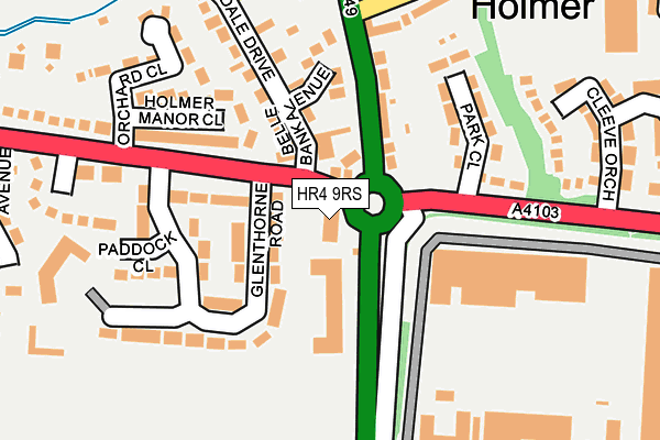
HR4 9RS lies on Holmer Road in Hereford. HR4 9RS is located in the Holmer electoral ward, within the unitary authority of Herefordshire, County of and the English Parliamentary constituency of Hereford and South Herefordshire. The Sub Integrated Care Board (ICB) Location is NHS Herefordshire and Worcestershire ICB - 18C and the police force is West Mercia. This postcode has been in use since January 1980.


GetTheData
Source: OS OpenMap – Local (Ordnance Survey)
Source: OS VectorMap District (Ordnance Survey)
Licence: Open Government Licence (requires attribution)
| Easting | 350577 |
| Northing | 242017 |
| Latitude | 52.074308 |
| Longitude | -2.722514 |
GetTheData
Source: Open Postcode Geo
Licence: Open Government Licence
| Street | Holmer Road |
| Town/City | Hereford |
| Country | England |
| Postcode District | HR4 |
| ➜ HR4 open data dashboard ➜ See where HR4 is on a map ➜ Where is Hereford? | |
GetTheData
Source: Land Registry Price Paid Data
Licence: Open Government Licence
Elevation or altitude of HR4 9RS as distance above sea level:
| Metres | Feet | |
|---|---|---|
| Elevation | 70m | 230ft |
Elevation is measured from the approximate centre of the postcode, to the nearest point on an OS contour line from OS Terrain 50, which has contour spacing of ten vertical metres.
➜ How high above sea level am I? Find the elevation of your current position using your device's GPS.
GetTheData
Source: Open Postcode Elevation
Licence: Open Government Licence
| Ward | Holmer |
| Constituency | Hereford And South Herefordshire |
GetTheData
Source: ONS Postcode Database
Licence: Open Government Licence
| November 2023 | Anti-social behaviour | On or near Stroucken Way | 264m |
| October 2023 | Criminal damage and arson | On or near Stroucken Way | 264m |
| September 2023 | Violence and sexual offences | On or near Stroucken Way | 264m |
| ➜ Holmer Road crime map and outcomes | |||
GetTheData
Source: data.police.uk
Licence: Open Government Licence
| Starting Gate (Roman Road (A4103)) | Holmer | 118m |
| Starting Gate (Roman Road (A4103)) | Holmer | 121m |
| Ballinger Court (Dewpond Close) | Holmer | 137m |
| Island (A49) | Holmer | 213m |
| Glenthorne Road (Roman Road) | Holmer | 218m |
| Hereford Station | 1.8km |
GetTheData
Source: NaPTAN
Licence: Open Government Licence
GetTheData
Source: ONS Postcode Database
Licence: Open Government Licence


➜ Get more ratings from the Food Standards Agency
GetTheData
Source: Food Standards Agency
Licence: FSA terms & conditions
| Last Collection | |||
|---|---|---|---|
| Location | Mon-Fri | Sat | Distance |
| Kempton Avenue | 18:15 | 11:45 | 861m |
| Sandown Drive | 18:30 | 11:45 | 1,314m |
| Commercial Road | 18:30 | 12:00 | 1,939m |
GetTheData
Source: Dracos
Licence: Creative Commons Attribution-ShareAlike
| Facility | Distance |
|---|---|
| Holmer Park Spa And Health Club Holmer, Hereford Health and Fitness Gym, Swimming Pool, Studio | 368m |
| Hereford Leisure Centre Holmer Road, Hereford Sports Hall, Athletics, Health and Fitness Gym, Grass Pitches, Golf, Artificial Grass Pitch, Studio, Squash Courts, Cycling | 515m |
| Puregym (Hereford) Holmer Road, Hereford Health and Fitness Gym | 588m |
GetTheData
Source: Active Places
Licence: Open Government Licence
| School | Phase of Education | Distance |
|---|---|---|
| Holmer CofE Academy Holmer Road, Hereford, HR4 9RX | Primary | 642m |
| The Brookfield School Grandstand Road, Hereford, HR4 9NG | Not applicable | 958m |
| St Francis Xavier's Primary School Venns Lane, Hereford, HR1 1DT | Primary | 1.2km |
GetTheData
Source: Edubase
Licence: Open Government Licence
The below table lists the International Territorial Level (ITL) codes (formerly Nomenclature of Territorial Units for Statistics (NUTS) codes) and Local Administrative Units (LAU) codes for HR4 9RS:
| ITL 1 Code | Name |
|---|---|
| TLG | West Midlands (England) |
| ITL 2 Code | Name |
| TLG1 | Herefordshire, Worcestershire and Warwickshire |
| ITL 3 Code | Name |
| TLG11 | Herefordshire, County of |
| LAU 1 Code | Name |
| E06000019 | Herefordshire, County of |
GetTheData
Source: ONS Postcode Directory
Licence: Open Government Licence
The below table lists the Census Output Area (OA), Lower Layer Super Output Area (LSOA), and Middle Layer Super Output Area (MSOA) for HR4 9RS:
| Code | Name | |
|---|---|---|
| OA | E00071126 | |
| LSOA | E01014084 | Herefordshire 010B |
| MSOA | E02002914 | Herefordshire 010 |
GetTheData
Source: ONS Postcode Directory
Licence: Open Government Licence
| HR4 9RW | Glenthorne Road | 88m |
| HR4 9RN | Roman Road | 140m |
| HR4 9RH | Holmer Terrace | 163m |
| HR4 9RL | Belle Bank Avenue | 172m |
| HR4 9RR | Dewpond Close | 174m |
| HR4 9RP | Paddock Close | 177m |
| HR4 9QZ | Holmer Manor Close | 217m |
| HR1 1LB | Park Close | 224m |
| HR4 9RJ | 225m | |
| HR4 9QU | Roman Road | 252m |
GetTheData
Source: Open Postcode Geo; Land Registry Price Paid Data
Licence: Open Government Licence