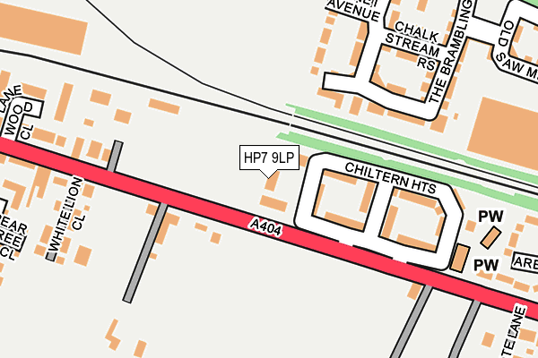
HP7 9LP lies on Repton Place in Amersham. HP7 9LP is located in the Little Chalfont and Amersham Common electoral ward, within the unitary authority of Buckinghamshire and the English Parliamentary constituency of Chesham and Amersham. The Sub Integrated Care Board (ICB) Location is NHS Buckinghamshire, Oxfordshire and Berkshire West ICB - 14Y and the police force is Thames Valley. This postcode has been in use since August 1993.


GetTheData
Source: OS OpenMap – Local (Ordnance Survey)
Source: OS VectorMap District (Ordnance Survey)
Licence: Open Government Licence (requires attribution)
| Easting | 498268 |
| Northing | 197877 |
| Latitude | 51.671082 |
| Longitude | -0.580374 |
GetTheData
Source: Open Postcode Geo
Licence: Open Government Licence
| Street | Repton Place |
| Town/City | Amersham |
| Country | England |
| Postcode District | HP7 |
| ➜ HP7 open data dashboard ➜ See where HP7 is on a map ➜ Where is Little Chalfont? | |
GetTheData
Source: Land Registry Price Paid Data
Licence: Open Government Licence
Elevation or altitude of HP7 9LP as distance above sea level:
| Metres | Feet | |
|---|---|---|
| Elevation | 130m | 427ft |
Elevation is measured from the approximate centre of the postcode, to the nearest point on an OS contour line from OS Terrain 50, which has contour spacing of ten vertical metres.
➜ How high above sea level am I? Find the elevation of your current position using your device's GPS.
GetTheData
Source: Open Postcode Elevation
Licence: Open Government Licence
| Ward | Little Chalfont And Amersham Common |
| Constituency | Chesham And Amersham |
GetTheData
Source: ONS Postcode Database
Licence: Open Government Licence
| January 2024 | Other crime | On or near Petrol Station | 200m |
| January 2024 | Violence and sexual offences | On or near Petrol Station | 200m |
| January 2024 | Vehicle crime | On or near Petrol Station | 200m |
| ➜ Get more crime data in our Crime section | |||
GetTheData
Source: data.police.uk
Licence: Open Government Licence
| Chiltern Heights (White Lion Road) | Amersham | 88m |
| Chiltern Heights (White Lion Road) | Amersham | 102m |
| The Pineapple Ph (White Lion Road) | Amersham | 162m |
| The Pineapple Ph (White Lion Road) | Amersham | 231m |
| The White Lion Ph (White Lion Road) | Amersham | 234m |
| Chalfont & Latimer Underground Station | Little Chalfont | 1,404m |
| Chalfont & Latimer Station | 1.4km |
| Amersham Station | 1.9km |
| Chorleywood Station | 4.7km |
GetTheData
Source: NaPTAN
Licence: Open Government Licence
GetTheData
Source: ONS Postcode Database
Licence: Open Government Licence


➜ Get more ratings from the Food Standards Agency
GetTheData
Source: Food Standards Agency
Licence: FSA terms & conditions
| Last Collection | |||
|---|---|---|---|
| Location | Mon-Fri | Sat | Distance |
| Quill Hall Lane | 17:00 | 11:45 | 605m |
| Lincoln Park | 17:15 | 11:30 | 753m |
| Blackhorse Bridge | 17:30 | 11:45 | 862m |
GetTheData
Source: Dracos
Licence: Creative Commons Attribution-ShareAlike
| Facility | Distance |
|---|---|
| Amersham Common Village Hall White Lion Road, Amersham Sports Hall | 467m |
| Chalfont Valley E-act Primary Academy Bell Lane, Amersham Grass Pitches | 565m |
| Stony Dean School Orchard End Avenue, Amersham Grass Pitches, Sports Hall, Artificial Grass Pitch | 567m |
GetTheData
Source: Active Places
Licence: Open Government Licence
| School | Phase of Education | Distance |
|---|---|---|
| Stony Dean School Orchard End Avenue, Pineapple Road, Amersham, HP7 9JW | Not applicable | 496m |
| Chalfont Valley E-ACT Primary Academy Bell Lane, Little Chalfont, Amersham, HP6 6PF | Primary | 565m |
| St George's Church of England Infant School White Lion Road, Amersham, HP7 9HX | Primary | 754m |
GetTheData
Source: Edubase
Licence: Open Government Licence
The below table lists the International Territorial Level (ITL) codes (formerly Nomenclature of Territorial Units for Statistics (NUTS) codes) and Local Administrative Units (LAU) codes for HP7 9LP:
| ITL 1 Code | Name |
|---|---|
| TLJ | South East (England) |
| ITL 2 Code | Name |
| TLJ1 | Berkshire, Buckinghamshire and Oxfordshire |
| ITL 3 Code | Name |
| TLJ13 | Buckinghamshire |
| LAU 1 Code | Name |
| E06000060 | Buckinghamshire |
GetTheData
Source: ONS Postcode Directory
Licence: Open Government Licence
The below table lists the Census Output Area (OA), Lower Layer Super Output Area (LSOA), and Middle Layer Super Output Area (MSOA) for HP7 9LP:
| Code | Name | |
|---|---|---|
| OA | E00089695 | |
| LSOA | E01017776 | Chiltern 008C |
| MSOA | E02003683 | Chiltern 008 |
GetTheData
Source: ONS Postcode Directory
Licence: Open Government Licence
| HP7 9RX | Chiltern Heights | 59m |
| HP6 6FQ | Meadow View | 117m |
| HP7 9JZ | Prospect Cottages | 133m |
| HP7 9JY | White Lion Road | 136m |
| HP6 6FP | The Bramblings | 157m |
| HP6 6FS | Chalk Stream Rise | 202m |
| HP6 6FR | Linnet Avenue | 203m |
| HP6 6FN | The Bramblings | 218m |
| HP7 9JS | White Lion Road | 234m |
| HP7 9JU | White Lion Close | 255m |
GetTheData
Source: Open Postcode Geo; Land Registry Price Paid Data
Licence: Open Government Licence