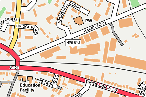
HP6 6YJ lies on Raans Road in Amersham. HP6 6YJ is located in the Little Chalfont and Amersham Common electoral ward, within the unitary authority of Buckinghamshire and the English Parliamentary constituency of Chesham and Amersham. The Sub Integrated Care Board (ICB) Location is NHS Buckinghamshire, Oxfordshire and Berkshire West ICB - 14Y and the police force is Thames Valley. This postcode has been in use since June 1999.


GetTheData
Source: OS OpenMap – Local (Ordnance Survey)
Source: OS VectorMap District (Ordnance Survey)
Licence: Open Government Licence (requires attribution)
| Easting | 497699 |
| Northing | 198118 |
| Latitude | 51.673351 |
| Longitude | -0.588510 |
GetTheData
Source: Open Postcode Geo
Licence: Open Government Licence
| Street | Raans Road |
| Town/City | Amersham |
| Country | England |
| Postcode District | HP6 |
| ➜ HP6 open data dashboard ➜ See where HP6 is on a map ➜ Where is Amersham? | |
GetTheData
Source: Land Registry Price Paid Data
Licence: Open Government Licence
Elevation or altitude of HP6 6YJ as distance above sea level:
| Metres | Feet | |
|---|---|---|
| Elevation | 140m | 459ft |
Elevation is measured from the approximate centre of the postcode, to the nearest point on an OS contour line from OS Terrain 50, which has contour spacing of ten vertical metres.
➜ How high above sea level am I? Find the elevation of your current position using your device's GPS.
GetTheData
Source: Open Postcode Elevation
Licence: Open Government Licence
| Ward | Little Chalfont And Amersham Common |
| Constituency | Chesham And Amersham |
GetTheData
Source: ONS Postcode Database
Licence: Open Government Licence
| January 2024 | Other crime | On or near Petrol Station | 426m |
| January 2024 | Violence and sexual offences | On or near Petrol Station | 426m |
| January 2024 | Vehicle crime | On or near Petrol Station | 426m |
| ➜ Raans Road crime map and outcomes | |||
GetTheData
Source: data.police.uk
Licence: Open Government Licence
| Village Hall (White Lion Road) | Amersham | 195m |
| Blackhorse Bridge (White Lion Road) | Amersham | 209m |
| Village Hall (White Lion Road) | Amersham | 247m |
| Blackhorse Bridge (White Lion Road) | Amersham | 269m |
| Blackhorse Close (Plantation Road) | Amersham | 271m |
| Amersham Underground Station | Amersham | 1,329m |
| Amersham Station | 1.3km |
| Chalfont & Latimer Station | 2km |
| Chorleywood Station | 5.3km |
GetTheData
Source: NaPTAN
Licence: Open Government Licence
GetTheData
Source: ONS Postcode Database
Licence: Open Government Licence


➜ Get more ratings from the Food Standards Agency
GetTheData
Source: Food Standards Agency
Licence: FSA terms & conditions
| Last Collection | |||
|---|---|---|---|
| Location | Mon-Fri | Sat | Distance |
| Blackhorse Bridge | 17:30 | 11:45 | 250m |
| Quill Hall Lane | 17:00 | 11:45 | 287m |
| Lincoln Park | 17:15 | 11:30 | 411m |
GetTheData
Source: Dracos
Licence: Creative Commons Attribution-ShareAlike
| Facility | Distance |
|---|---|
| Amersham Polish Club Raans Road, Amersham Sports Hall | 161m |
| Amersham Common Village Hall White Lion Road, Amersham Sports Hall | 169m |
| Ranns School (Closed) Amersham Grass Pitches | 182m |
GetTheData
Source: Active Places
Licence: Open Government Licence
| School | Phase of Education | Distance |
|---|---|---|
| St George's Church of England Infant School White Lion Road, Amersham, HP7 9HX | Primary | 215m |
| Stony Dean School Orchard End Avenue, Pineapple Road, Amersham, HP7 9JW | Not applicable | 358m |
| Henry Allen Nursery School Mitchell Walk, Amersham, HP6 6NW | Nursery | 467m |
GetTheData
Source: Edubase
Licence: Open Government Licence
The below table lists the International Territorial Level (ITL) codes (formerly Nomenclature of Territorial Units for Statistics (NUTS) codes) and Local Administrative Units (LAU) codes for HP6 6YJ:
| ITL 1 Code | Name |
|---|---|
| TLJ | South East (England) |
| ITL 2 Code | Name |
| TLJ1 | Berkshire, Buckinghamshire and Oxfordshire |
| ITL 3 Code | Name |
| TLJ13 | Buckinghamshire |
| LAU 1 Code | Name |
| E06000060 | Buckinghamshire |
GetTheData
Source: ONS Postcode Directory
Licence: Open Government Licence
The below table lists the Census Output Area (OA), Lower Layer Super Output Area (LSOA), and Middle Layer Super Output Area (MSOA) for HP6 6YJ:
| Code | Name | |
|---|---|---|
| OA | E00089513 | |
| LSOA | E01017740 | Chiltern 007B |
| MSOA | E02003682 | Chiltern 007 |
GetTheData
Source: ONS Postcode Directory
Licence: Open Government Licence
| HP6 6JQ | Raans Road | 78m |
| HP6 6FB | Corinium Industrial Estate | 103m |
| HP7 9HZ | White Lion Road | 135m |
| HP7 9HX | White Lion Road | 161m |
| HP7 9HY | Lime Tree Walk | 161m |
| HP7 9JD | White Lion Road | 161m |
| HP6 6FH | Brudenell Close | 162m |
| HP6 6JF | Bridge Place | 184m |
| HP6 6UU | Stretton Place | 218m |
| HP6 6NX | Woodside Road | 219m |
GetTheData
Source: Open Postcode Geo; Land Registry Price Paid Data
Licence: Open Government Licence