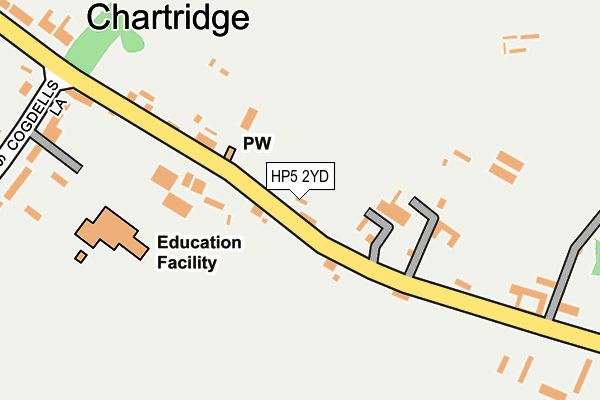
HP5 2YD is located in the Chiltern Ridges electoral ward, within the unitary authority of Buckinghamshire and the English Parliamentary constituency of Chesham and Amersham. The Sub Integrated Care Board (ICB) Location is NHS Buckinghamshire, Oxfordshire and Berkshire West ICB - 14Y and the police force is Thames Valley. This postcode has been in use since June 1999.


GetTheData
Source: OS OpenMap – Local (Ordnance Survey)
Source: OS VectorMap District (Ordnance Survey)
Licence: Open Government Licence (requires attribution)
| Easting | 493223 |
| Northing | 203717 |
| Latitude | 51.724434 |
| Longitude | -0.651747 |
GetTheData
Source: Open Postcode Geo
Licence: Open Government Licence
| Country | England |
| Postcode District | HP5 |
| ➜ HP5 open data dashboard ➜ See where HP5 is on a map ➜ Where is Chartridge? | |
GetTheData
Source: Land Registry Price Paid Data
Licence: Open Government Licence
Elevation or altitude of HP5 2YD as distance above sea level:
| Metres | Feet | |
|---|---|---|
| Elevation | 170m | 558ft |
Elevation is measured from the approximate centre of the postcode, to the nearest point on an OS contour line from OS Terrain 50, which has contour spacing of ten vertical metres.
➜ How high above sea level am I? Find the elevation of your current position using your device's GPS.
GetTheData
Source: Open Postcode Elevation
Licence: Open Government Licence
| Ward | Chiltern Ridges |
| Constituency | Chesham And Amersham |
GetTheData
Source: ONS Postcode Database
Licence: Open Government Licence
| November 2021 | Criminal damage and arson | On or near Cogdells Lane | 287m |
| November 2021 | Criminal damage and arson | On or near Cogdells Lane | 287m |
| July 2021 | Violence and sexual offences | On or near Cogdells Lane | 287m |
| ➜ Get more crime data in our Crime section | |||
GetTheData
Source: data.police.uk
Licence: Open Government Licence
| The Bell Ph (Chartridge Lane) | Chartridge | 29m |
| The Bell Ph (Chartridge Lane) | Chartridge | 60m |
| Cogdells Lane (Chartridge Lane) | Chartridge | 231m |
| Cogdell's Lane (Chartridge Lane) | Chartridge | 248m |
| Village Hall (Chartridge Lane) | Chartridge | 278m |
| Great Missenden Station | 4.6km |
GetTheData
Source: NaPTAN
Licence: Open Government Licence
GetTheData
Source: ONS Postcode Database
Licence: Open Government Licence


➜ Get more ratings from the Food Standards Agency
GetTheData
Source: Food Standards Agency
Licence: FSA terms & conditions
| Last Collection | |||
|---|---|---|---|
| Location | Mon-Fri | Sat | Distance |
| The Sachs | 16:30 | 09:00 | 447m |
| Asheridge | 15:00 | 09:00 | 1,064m |
| Boundry | 16:45 | 12:00 | 1,490m |
GetTheData
Source: Dracos
Licence: Creative Commons Attribution-ShareAlike
| Facility | Distance |
|---|---|
| Chartridge Combined School Cogdells Lane, Chartridge, Chesham Grass Pitches | 190m |
| Chartridge Village Hall Chartridge, Chesham Studio | 251m |
| Franklin Playing Fields Cogdells Close, Chartridge Grass Pitches | 407m |
GetTheData
Source: Active Places
Licence: Open Government Licence
| School | Phase of Education | Distance |
|---|---|---|
| Chartridge Combined School Cogdells Lane, Chartridge, Chesham, HP5 2TW | Primary | 195m |
| Ivingswood Academy Greenway, Chesham, HP5 2BY | Primary | 2.6km |
| Lee Common Church of England School Lee Common, Oxford Street, Great Missenden, HP16 9JH | Primary | 2.6km |
GetTheData
Source: Edubase
Licence: Open Government Licence
The below table lists the International Territorial Level (ITL) codes (formerly Nomenclature of Territorial Units for Statistics (NUTS) codes) and Local Administrative Units (LAU) codes for HP5 2YD:
| ITL 1 Code | Name |
|---|---|
| TLJ | South East (England) |
| ITL 2 Code | Name |
| TLJ1 | Berkshire, Buckinghamshire and Oxfordshire |
| ITL 3 Code | Name |
| TLJ13 | Buckinghamshire |
| LAU 1 Code | Name |
| E06000060 | Buckinghamshire |
GetTheData
Source: ONS Postcode Directory
Licence: Open Government Licence
The below table lists the Census Output Area (OA), Lower Layer Super Output Area (LSOA), and Middle Layer Super Output Area (MSOA) for HP5 2YD:
| Code | Name | |
|---|---|---|
| OA | E00089574 | |
| LSOA | E01017752 | Chiltern 001B |
| MSOA | E02003676 | Chiltern 001 |
GetTheData
Source: ONS Postcode Directory
Licence: Open Government Licence
| HP5 2TQ | 92m | |
| HP5 2TJ | Chapel Cottages | 110m |
| HP5 2TL | 198m | |
| HP5 2TF | 234m | |
| HP5 2TN | Reading Room Cottages | 245m |
| HP5 2TW | Cogdells Lane | 280m |
| HP5 2TR | Cogdells Close | 341m |
| HP5 2TS | Chartridge Lane | 356m |
| HP5 2TG | Grange Drive | 357m |
| HP5 2TT | 548m |
GetTheData
Source: Open Postcode Geo; Land Registry Price Paid Data
Licence: Open Government Licence