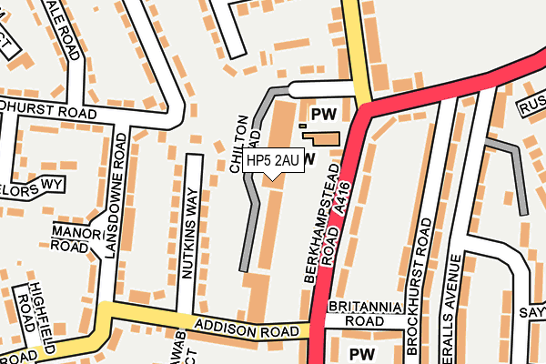
HP5 2AU is located in the Chesham electoral ward, within the unitary authority of Buckinghamshire and the English Parliamentary constituency of Chesham and Amersham. The Sub Integrated Care Board (ICB) Location is NHS Buckinghamshire, Oxfordshire and Berkshire West ICB - 14Y and the police force is Thames Valley. This postcode has been in use since January 1980.


GetTheData
Source: OS OpenMap – Local (Ordnance Survey)
Source: OS VectorMap District (Ordnance Survey)
Licence: Open Government Licence (requires attribution)
| Easting | 496222 |
| Northing | 202841 |
| Latitude | 51.716055 |
| Longitude | -0.608584 |
GetTheData
Source: Open Postcode Geo
Licence: Open Government Licence
| Country | England |
| Postcode District | HP5 |
| ➜ HP5 open data dashboard ➜ See where HP5 is on a map ➜ Where is Chesham? | |
GetTheData
Source: Land Registry Price Paid Data
Licence: Open Government Licence
Elevation or altitude of HP5 2AU as distance above sea level:
| Metres | Feet | |
|---|---|---|
| Elevation | 110m | 361ft |
Elevation is measured from the approximate centre of the postcode, to the nearest point on an OS contour line from OS Terrain 50, which has contour spacing of ten vertical metres.
➜ How high above sea level am I? Find the elevation of your current position using your device's GPS.
GetTheData
Source: Open Postcode Elevation
Licence: Open Government Licence
| Ward | Chesham |
| Constituency | Chesham And Amersham |
GetTheData
Source: ONS Postcode Database
Licence: Open Government Licence
| January 2024 | Other theft | On or near Petrol Station | 168m |
| November 2023 | Violence and sexual offences | On or near Chilton Road | 28m |
| November 2023 | Other crime | On or near Chilton Road | 28m |
| ➜ Get more crime data in our Crime section | |||
GetTheData
Source: data.police.uk
Licence: Open Government Licence
| The Nash Arms Ph (Berkhampstead Road) | Chesham | 94m |
| The Nash Arms Ph (Berkhampstead Road) | Chesham | 100m |
| Addison Road | Chesham | 164m |
| Lansdowne Road | Chesham | 201m |
| Lansdowne Road | Chesham | 209m |
| Chesham Underground Station | Chesham | 1,216m |
| Amersham Station | 4.7km |
GetTheData
Source: NaPTAN
Licence: Open Government Licence
| Median download speed | 40.0Mbps |
| Average download speed | 45.3Mbps |
| Maximum download speed | 80.00Mbps |
| Median upload speed | 2.0Mbps |
| Average upload speed | 8.8Mbps |
| Maximum upload speed | 20.00Mbps |
GetTheData
Source: Ofcom
Licence: Ofcom Terms of Use (requires attribution)
GetTheData
Source: ONS Postcode Database
Licence: Open Government Licence


➜ Get more ratings from the Food Standards Agency
GetTheData
Source: Food Standards Agency
Licence: FSA terms & conditions
| Last Collection | |||
|---|---|---|---|
| Location | Mon-Fri | Sat | Distance |
| The Vale | 17:15 | 12:00 | 132m |
| Greenway | 17:15 | 12:00 | 537m |
| Bellingdon Road | 17:15 | 11:45 | 560m |
GetTheData
Source: Dracos
Licence: Creative Commons Attribution-ShareAlike
| Facility | Distance |
|---|---|
| Windsor Road Recreation Ground Windsor Road, Chesham Grass Pitches | 461m |
| Brushwood Junior School Brushwood Road, Chesham Grass Pitches | 864m |
| Chesham Athletic Fc (The Grange) Waller Way, Chesham Grass Pitches | 896m |
GetTheData
Source: Active Places
Licence: Open Government Licence
| School | Phase of Education | Distance |
|---|---|---|
| Newtown School Berkhampstead Road, Chesham, HP5 3AT | Primary | 255m |
| Ivingswood Academy Greenway, Chesham, HP5 2BY | Primary | 693m |
| Heritage House School Cameron Road, Chesham, HP5 3BP | Not applicable | 728m |
GetTheData
Source: Edubase
Licence: Open Government Licence
The below table lists the International Territorial Level (ITL) codes (formerly Nomenclature of Territorial Units for Statistics (NUTS) codes) and Local Administrative Units (LAU) codes for HP5 2AU:
| ITL 1 Code | Name |
|---|---|
| TLJ | South East (England) |
| ITL 2 Code | Name |
| TLJ1 | Berkshire, Buckinghamshire and Oxfordshire |
| ITL 3 Code | Name |
| TLJ13 | Buckinghamshire |
| LAU 1 Code | Name |
| E06000060 | Buckinghamshire |
GetTheData
Source: ONS Postcode Directory
Licence: Open Government Licence
The below table lists the Census Output Area (OA), Lower Layer Super Output Area (LSOA), and Middle Layer Super Output Area (MSOA) for HP5 2AU:
| Code | Name | |
|---|---|---|
| OA | E00089792 | |
| LSOA | E01017795 | Chiltern 002F |
| MSOA | E02003677 | Chiltern 002 |
GetTheData
Source: ONS Postcode Directory
Licence: Open Government Licence
| HP5 3HQ | Berkhampstead Road | 72m |
| HP5 2BE | Nutkins Way | 89m |
| HP5 3HG | Berkhampstead Road | 90m |
| HP5 3AU | Berkhampstead Road | 103m |
| HP5 2AT | Chilton Road | 129m |
| HP5 3JE | Brockhurst Road | 158m |
| HP5 2BA | Lansdowne Road | 161m |
| HP5 3JF | Nashleigh Hill | 161m |
| HP5 2AX | Glenister Road | 170m |
| HP5 2DY | Lyndhurst Road | 184m |
GetTheData
Source: Open Postcode Geo; Land Registry Price Paid Data
Licence: Open Government Licence