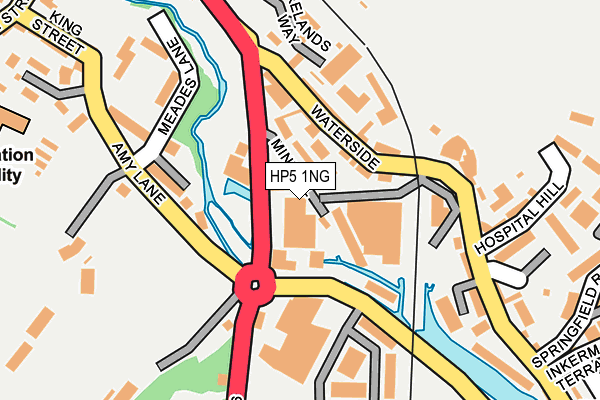
HP5 1NG lies on Amersham Road in Chesham. HP5 1NG is located in the Chess Valley electoral ward, within the unitary authority of Buckinghamshire and the English Parliamentary constituency of Chesham and Amersham. The Sub Integrated Care Board (ICB) Location is NHS Buckinghamshire, Oxfordshire and Berkshire West ICB - 14Y and the police force is Thames Valley. This postcode has been in use since January 1980.


GetTheData
Source: OS OpenMap – Local (Ordnance Survey)
Source: OS VectorMap District (Ordnance Survey)
Licence: Open Government Licence (requires attribution)
| Easting | 496126 |
| Northing | 201110 |
| Latitude | 51.700512 |
| Longitude | -0.610450 |
GetTheData
Source: Open Postcode Geo
Licence: Open Government Licence
| Street | Amersham Road |
| Town/City | Chesham |
| Country | England |
| Postcode District | HP5 |
➜ See where HP5 is on a map ➜ Where is Chesham? | |
GetTheData
Source: Land Registry Price Paid Data
Licence: Open Government Licence
Elevation or altitude of HP5 1NG as distance above sea level:
| Metres | Feet | |
|---|---|---|
| Elevation | 100m | 328ft |
Elevation is measured from the approximate centre of the postcode, to the nearest point on an OS contour line from OS Terrain 50, which has contour spacing of ten vertical metres.
➜ How high above sea level am I? Find the elevation of your current position using your device's GPS.
GetTheData
Source: Open Postcode Elevation
Licence: Open Government Licence
| Ward | Chess Valley |
| Constituency | Chesham And Amersham |
GetTheData
Source: ONS Postcode Database
Licence: Open Government Licence
| The Wild Rover Ph (Red Lion Street) | Chesham | 64m |
| The Wild Rover Ph (Red Lion Street) | Chesham | 94m |
| Hospital Hill (Waterside) | Waterside | 175m |
| Hospital Hill (Gordon Road) | Waterside | 197m |
| Red Lion Street | Chesham | 215m |
| Chesham Underground Station | Chesham | 528m |
| Amersham Station | 2.9km |
| Chalfont & Latimer Station | 5km |
GetTheData
Source: NaPTAN
Licence: Open Government Licence
GetTheData
Source: ONS Postcode Database
Licence: Open Government Licence

➜ Get more ratings from the Food Standards Agency
GetTheData
Source: Food Standards Agency
Licence: FSA terms & conditions
| Last Collection | |||
|---|---|---|---|
| Location | Mon-Fri | Sat | Distance |
| Waterside P.o. | 17:15 | 12:00 | 92m |
| Market Square | 17:00 | 12:00 | 374m |
| Christchurch | 17:15 | 12:00 | 399m |
GetTheData
Source: Dracos
Licence: Creative Commons Attribution-ShareAlike
| Risk of HP5 1NG flooding from rivers and sea | Medium |
| ➜ HP5 1NG flood map | |
GetTheData
Source: Open Flood Risk by Postcode
Licence: Open Government Licence
The below table lists the International Territorial Level (ITL) codes (formerly Nomenclature of Territorial Units for Statistics (NUTS) codes) and Local Administrative Units (LAU) codes for HP5 1NG:
| ITL 1 Code | Name |
|---|---|
| TLJ | South East (England) |
| ITL 2 Code | Name |
| TLJ1 | Berkshire, Buckinghamshire and Oxfordshire |
| ITL 3 Code | Name |
| TLJ13 | Buckinghamshire |
| LAU 1 Code | Name |
| E06000060 | Buckinghamshire |
GetTheData
Source: ONS Postcode Directory
Licence: Open Government Licence
The below table lists the Census Output Area (OA), Lower Layer Super Output Area (LSOA), and Middle Layer Super Output Area (MSOA) for HP5 1NG:
| Code | Name | |
|---|---|---|
| OA | E00089772 | |
| LSOA | E01017792 | Chiltern 004C |
| MSOA | E02003679 | Chiltern 004 |
GetTheData
Source: ONS Postcode Directory
Licence: Open Government Licence
| HP5 1NL | Mineral Lane | 39m |
| HP5 1NJ | Mineral Lane | 56m |
| HP5 1PE | Waterside | 89m |
| HP5 1PF | Waterside | 102m |
| HP5 1PD | Waterside | 131m |
| HP5 1ND | Meades Lane | 170m |
| HP5 1PR | Waterside | 183m |
| HP5 1QP | Forelands Way | 194m |
| HP5 1SD | Moor Road | 195m |
| HP5 1PG | Waterside | 196m |
GetTheData
Source: Open Postcode Geo; Land Registry Price Paid Data
Licence: Open Government Licence