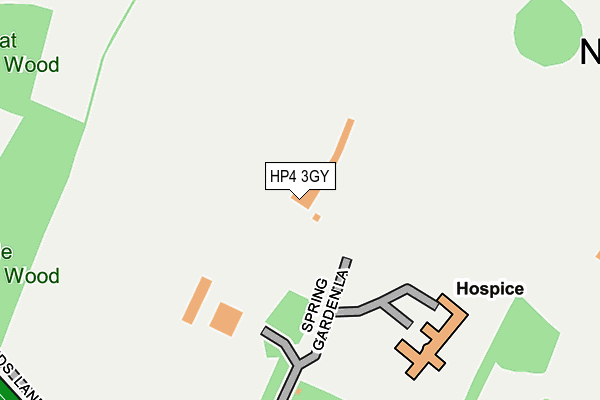
HP4 3GY is located in the Northchurch electoral ward, within the local authority district of Dacorum and the English Parliamentary constituency of South West Hertfordshire. The Sub Integrated Care Board (ICB) Location is NHS Hertfordshire and West Essex ICB - 06N and the police force is Hertfordshire. This postcode has been in use since January 2007.


GetTheData
Source: OS OpenMap – Local (Ordnance Survey)
Source: OS VectorMap District (Ordnance Survey)
Licence: Open Government Licence (requires attribution)
| Easting | 496606 |
| Northing | 208573 |
| Latitude | 51.767510 |
| Longitude | -0.601437 |
GetTheData
Source: Open Postcode Geo
Licence: Open Government Licence
| Country | England |
| Postcode District | HP4 |
| ➜ HP4 open data dashboard ➜ See where HP4 is on a map ➜ Where is Berkhamsted? | |
GetTheData
Source: Land Registry Price Paid Data
Licence: Open Government Licence
Elevation or altitude of HP4 3GY as distance above sea level:
| Metres | Feet | |
|---|---|---|
| Elevation | 170m | 558ft |
Elevation is measured from the approximate centre of the postcode, to the nearest point on an OS contour line from OS Terrain 50, which has contour spacing of ten vertical metres.
➜ How high above sea level am I? Find the elevation of your current position using your device's GPS.
GetTheData
Source: Open Postcode Elevation
Licence: Open Government Licence
| Ward | Northchurch |
| Constituency | South West Hertfordshire |
GetTheData
Source: ONS Postcode Database
Licence: Open Government Licence
| June 2022 | Criminal damage and arson | On or near Darr'S Lane | 387m |
| June 2022 | Anti-social behaviour | On or near Darr'S Lane | 387m |
| March 2022 | Violence and sexual offences | On or near St Mary'S Avenue | 447m |
| ➜ Get more crime data in our Crime section | |||
GetTheData
Source: data.police.uk
Licence: Open Government Licence
| Granville Road | Northchurch | 549m |
| Granville Road | Northchurch | 556m |
| Darr's Lane (High Street) | Northchurch | 718m |
| Darr's Lane (High Street) | Northchurch | 728m |
| Dudswell Lane (High Street) | Dudswell | 743m |
| Berkhamsted Station | 2.8km |
| Tring Station | 4km |
GetTheData
Source: NaPTAN
Licence: Open Government Licence
GetTheData
Source: ONS Postcode Database
Licence: Open Government Licence


➜ Get more ratings from the Food Standards Agency
GetTheData
Source: Food Standards Agency
Licence: FSA terms & conditions
| Last Collection | |||
|---|---|---|---|
| Location | Mon-Fri | Sat | Distance |
| Rossway | 17:15 | 08:00 | 493m |
| Covert Close | 17:15 | 11:30 | 513m |
| Northchurch P.o. | 17:15 | 11:30 | 708m |
GetTheData
Source: Dracos
Licence: Creative Commons Attribution-ShareAlike
| Facility | Distance |
|---|---|
| Berkhamsted Golf Range (Closed) Spring Garden Lane, Berkhamsted Golf | 6m |
| Northchurch Recreation Ground Tring Road, Northchurch, Berkhamsted Grass Pitches | 718m |
| Northchurch Sports Ground Tring Road, Northchurch, Berkhamsted Grass Pitches, Outdoor Tennis Courts | 818m |
GetTheData
Source: Active Places
Licence: Open Government Licence
| School | Phase of Education | Distance |
|---|---|---|
| St Mary's CofE Primary School, Northchurch Northchurch, Berkhamsted, HP4 3QZ | Primary | 892m |
| Egerton-Rothesay School Durrants Lane, Berkhamsted, HP4 3UJ | Not applicable | 1.1km |
| Westfield Primary School Durrants Lane, Berkhamsted, HP4 3PJ | Primary | 1.1km |
GetTheData
Source: Edubase
Licence: Open Government Licence
The below table lists the International Territorial Level (ITL) codes (formerly Nomenclature of Territorial Units for Statistics (NUTS) codes) and Local Administrative Units (LAU) codes for HP4 3GY:
| ITL 1 Code | Name |
|---|---|
| TLH | East |
| ITL 2 Code | Name |
| TLH2 | Bedfordshire and Hertfordshire |
| ITL 3 Code | Name |
| TLH23 | Hertfordshire CC |
| LAU 1 Code | Name |
| E07000096 | Dacorum |
GetTheData
Source: ONS Postcode Directory
Licence: Open Government Licence
The below table lists the Census Output Area (OA), Lower Layer Super Output Area (LSOA), and Middle Layer Super Output Area (MSOA) for HP4 3GY:
| Code | Name | |
|---|---|---|
| OA | E00118951 | |
| LSOA | E01023416 | Dacorum 006C |
| MSOA | E02004861 | Dacorum 006 |
GetTheData
Source: ONS Postcode Directory
Licence: Open Government Licence
| HP4 3TX | The Larches | 355m |
| HP4 3TT | Darrs Lane | 396m |
| HP4 3RP | St Marys Avenue | 423m |
| HP4 3SB | Paynes Field Close | 456m |
| HP4 3SR | Covert Close | 471m |
| HP4 3RW | St Marys Avenue | 471m |
| HP4 3RJ | Darrs Lane | 492m |
| HP4 3TY | Shootersway | 500m |
| HP4 3RS | Covert Road | 509m |
| HP4 3SS | Covert Road | 522m |
GetTheData
Source: Open Postcode Geo; Land Registry Price Paid Data
Licence: Open Government Licence