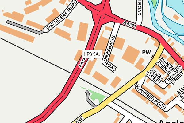
HP3 9AJ is located in the Apsley and Corner Hall electoral ward, within the local authority district of Dacorum and the English Parliamentary constituency of Hemel Hempstead. The Sub Integrated Care Board (ICB) Location is NHS Hertfordshire and West Essex ICB - 06N and the police force is Hertfordshire. This postcode has been in use since January 1980.


GetTheData
Source: OS OpenMap – Local (Ordnance Survey)
Source: OS VectorMap District (Ordnance Survey)
Licence: Open Government Licence (requires attribution)
| Easting | 505428 |
| Northing | 205561 |
| Latitude | 51.738856 |
| Longitude | -0.474531 |
GetTheData
Source: Open Postcode Geo
Licence: Open Government Licence
| Country | England |
| Postcode District | HP3 |
| ➜ HP3 open data dashboard ➜ See where HP3 is on a map ➜ Where is Hemel Hempstead? | |
GetTheData
Source: Land Registry Price Paid Data
Licence: Open Government Licence
Elevation or altitude of HP3 9AJ as distance above sea level:
| Metres | Feet | |
|---|---|---|
| Elevation | 90m | 295ft |
Elevation is measured from the approximate centre of the postcode, to the nearest point on an OS contour line from OS Terrain 50, which has contour spacing of ten vertical metres.
➜ How high above sea level am I? Find the elevation of your current position using your device's GPS.
GetTheData
Source: Open Postcode Elevation
Licence: Open Government Licence
| Ward | Apsley And Corner Hall |
| Constituency | Hemel Hempstead |
GetTheData
Source: ONS Postcode Database
Licence: Open Government Licence
| January 2024 | Violence and sexual offences | On or near Orchard Street | 209m |
| January 2024 | Public order | On or near Orchard Street | 209m |
| January 2024 | Violence and sexual offences | On or near Orchard Street | 209m |
| ➜ Get more crime data in our Crime section | |||
GetTheData
Source: data.police.uk
Licence: Open Government Licence
| Two Waters Road (London Road) | Two Waters | 165m |
| Durrants Hill Road (London Road) | Two Waters | 187m |
| Bus Garage (Off Whiteleaf Road) | Two Waters | 202m |
| London Road (Two Waters Road) | Two Waters | 234m |
| Durrants Hill Road (London Road) | Two Waters | 238m |
| Apsley Station | 1.1km |
| Hemel Hempstead Station | 1.2km |
| Kings Langley Station | 4.4km |
GetTheData
Source: NaPTAN
Licence: Open Government Licence
GetTheData
Source: ONS Postcode Database
Licence: Open Government Licence


➜ Get more ratings from the Food Standards Agency
GetTheData
Source: Food Standards Agency
Licence: FSA terms & conditions
| Last Collection | |||
|---|---|---|---|
| Location | Mon-Fri | Sat | Distance |
| Apsley P.o. | 18:30 | 12:00 | 213m |
| King Edward Street | 17:30 | 12:00 | 229m |
| Highbridge Road | 17:30 | 12:00 | 595m |
GetTheData
Source: Dracos
Licence: Creative Commons Attribution-ShareAlike
| Facility | Distance |
|---|---|
| Hemel Hempstead Town Cricket Club Heath Park, Station Road, Hemel Hempstead Grass Pitches | 557m |
| Two Waters Primary School High Ridge Road, Hemel Hempstead Grass Pitches | 633m |
| Hemel Hempstead Leisure Centre Park Road, Hemel Hempstead Sports Hall, Swimming Pool, Health and Fitness Gym, Artificial Grass Pitch, Studio, Squash Courts | 781m |
GetTheData
Source: Active Places
Licence: Open Government Licence
| School | Phase of Education | Distance |
|---|---|---|
| Two Waters Primary School High Ridge Close, Apsley, Hemel Hempstead, HP3 0AU | Primary | 633m |
| Tudor Primary School Redwood Drive, Hemel Hempstead, HP3 9ER | Primary | 1.1km |
| The Hemel Hempstead School Heath Lane, The Hemel Hempstead School, Heath Lane, Hemel Hempstead, HP1 1TX | Secondary | 1.2km |
GetTheData
Source: Edubase
Licence: Open Government Licence
The below table lists the International Territorial Level (ITL) codes (formerly Nomenclature of Territorial Units for Statistics (NUTS) codes) and Local Administrative Units (LAU) codes for HP3 9AJ:
| ITL 1 Code | Name |
|---|---|
| TLH | East |
| ITL 2 Code | Name |
| TLH2 | Bedfordshire and Hertfordshire |
| ITL 3 Code | Name |
| TLH23 | Hertfordshire CC |
| LAU 1 Code | Name |
| E07000096 | Dacorum |
GetTheData
Source: ONS Postcode Directory
Licence: Open Government Licence
The below table lists the Census Output Area (OA), Lower Layer Super Output Area (LSOA), and Middle Layer Super Output Area (MSOA) for HP3 9AJ:
| Code | Name | |
|---|---|---|
| OA | E00118653 | |
| LSOA | E01023354 | Dacorum 018B |
| MSOA | E02004873 | Dacorum 018 |
GetTheData
Source: ONS Postcode Directory
Licence: Open Government Licence
| HP3 9AA | London Road | 59m |
| HP3 9DJ | Featherbed Lane | 128m |
| HP3 9DW | Manor Avenue | 165m |
| HP3 9DU | Henry Street | 179m |
| HP3 9DX | Winifred Road | 183m |
| HP3 9DT | Orchard Street | 214m |
| HP3 9SD | London Road | 229m |
| HP3 9SE | London Road | 236m |
| HP3 9SG | Storey Street | 247m |
| HP3 0AQ | Chipperfield Road | 259m |
GetTheData
Source: Open Postcode Geo; Land Registry Price Paid Data
Licence: Open Government Licence