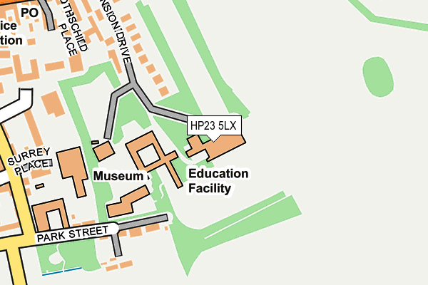
HP23 5LX is located in the Tring East electoral ward, within the local authority district of Dacorum and the English Parliamentary constituency of South West Hertfordshire. The Sub Integrated Care Board (ICB) Location is NHS Hertfordshire and West Essex ICB - 06N and the police force is Hertfordshire. This postcode has been in use since January 1980.


GetTheData
Source: OS OpenMap – Local (Ordnance Survey)
Source: OS VectorMap District (Ordnance Survey)
Licence: Open Government Licence (requires attribution)
| Easting | 492672 |
| Northing | 211192 |
| Latitude | 51.791715 |
| Longitude | -0.657731 |
GetTheData
Source: Open Postcode Geo
Licence: Open Government Licence
| Country | England |
| Postcode District | HP23 |
| ➜ HP23 open data dashboard ➜ See where HP23 is on a map ➜ Where is Tring? | |
GetTheData
Source: Land Registry Price Paid Data
Licence: Open Government Licence
Elevation or altitude of HP23 5LX as distance above sea level:
| Metres | Feet | |
|---|---|---|
| Elevation | 140m | 459ft |
Elevation is measured from the approximate centre of the postcode, to the nearest point on an OS contour line from OS Terrain 50, which has contour spacing of ten vertical metres.
➜ How high above sea level am I? Find the elevation of your current position using your device's GPS.
GetTheData
Source: Open Postcode Elevation
Licence: Open Government Licence
| Ward | Tring East |
| Constituency | South West Hertfordshire |
GetTheData
Source: ONS Postcode Database
Licence: Open Government Licence
| December 2023 | Violence and sexual offences | On or near Parking Area | 472m |
| October 2023 | Violence and sexual offences | On or near Parking Area | 472m |
| September 2023 | Anti-social behaviour | On or near Parking Area | 472m |
| ➜ Get more crime data in our Crime section | |||
GetTheData
Source: data.police.uk
Licence: Open Government Licence
| Church Square (High Street) | Tring | 301m |
| Church Square (High Street) | Tring | 313m |
| Tesco | Upper Dunsley | 385m |
| Market Place (Brook Street) | Tring | 421m |
| Tesco (London Road) | Upper Dunsley | 428m |
| Tring Station | 2.6km |
GetTheData
Source: NaPTAN
Licence: Open Government Licence
GetTheData
Source: ONS Postcode Database
Licence: Open Government Licence


➜ Get more ratings from the Food Standards Agency
GetTheData
Source: Food Standards Agency
Licence: FSA terms & conditions
| Last Collection | |||
|---|---|---|---|
| Location | Mon-Fri | Sat | Distance |
| Akeman Street | 17:15 | 11:00 | 275m |
| Church Square | 17:30 | 11:00 | 315m |
| Dolphin Square | 18:00 | 12:00 | 317m |
GetTheData
Source: Dracos
Licence: Creative Commons Attribution-ShareAlike
| Facility | Distance |
|---|---|
| The Gym Tring High Street, Tring Health and Fitness Gym, Studio | 326m |
| Exclusively Ladies (Tring) (Closed) Mortimer Hill, Tring Health and Fitness Gym, Studio | 420m |
| Pound Meadow Station Road, Tring Grass Pitches, Outdoor Tennis Courts | 465m |
GetTheData
Source: Active Places
Licence: Open Government Licence
| School | Phase of Education | Distance |
|---|---|---|
| Tring Park School for the Performing Arts Mansion Drive, Tring, HP23 5LX | Not applicable | 9m |
| Bishop Wood Church of England Junior School, Tring Frogmore Street, Tring, HP23 5AU | Primary | 418m |
| Tring School Mortimer Hill, Tring, HP23 5JD | Secondary | 750m |
GetTheData
Source: Edubase
Licence: Open Government Licence
The below table lists the International Territorial Level (ITL) codes (formerly Nomenclature of Territorial Units for Statistics (NUTS) codes) and Local Administrative Units (LAU) codes for HP23 5LX:
| ITL 1 Code | Name |
|---|---|
| TLH | East |
| ITL 2 Code | Name |
| TLH2 | Bedfordshire and Hertfordshire |
| ITL 3 Code | Name |
| TLH23 | Hertfordshire CC |
| LAU 1 Code | Name |
| E07000096 | Dacorum |
GetTheData
Source: ONS Postcode Directory
Licence: Open Government Licence
The below table lists the Census Output Area (OA), Lower Layer Super Output Area (LSOA), and Middle Layer Super Output Area (MSOA) for HP23 5LX:
| Code | Name | |
|---|---|---|
| OA | E00118990 | |
| LSOA | E01023426 | Dacorum 002D |
| MSOA | E02004857 | Dacorum 002 |
GetTheData
Source: ONS Postcode Directory
Licence: Open Government Licence
| HP23 5BD | Mansion Drive | 172m |
| HP23 6AW | Park Street | 187m |
| HP23 5FG | Rose Gardens | 226m |
| HP23 5FJ | Rothschild Place | 233m |
| HP23 6AL | Surrey Place | 250m |
| HP23 6AJ | Rodwell Yard | 260m |
| HP23 5AY | Crown Rose Court | 263m |
| HP23 5FL | Rothschild Place | 271m |
| HP23 6AN | Akeman Street | 291m |
| HP23 5AH | High Street | 307m |
GetTheData
Source: Open Postcode Geo; Land Registry Price Paid Data
Licence: Open Government Licence