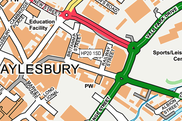
HP20 1SD is located in the Aylesbury North electoral ward, within the unitary authority of Buckinghamshire and the English Parliamentary constituency of Aylesbury. The Sub Integrated Care Board (ICB) Location is NHS Buckinghamshire, Oxfordshire and Berkshire West ICB - 14Y and the police force is Thames Valley. This postcode has been in use since December 2016.


GetTheData
Source: OS OpenMap – Local (Ordnance Survey)
Source: OS VectorMap District (Ordnance Survey)
Licence: Open Government Licence (requires attribution)
| Easting | 482216 |
| Northing | 213749 |
| Latitude | 51.816340 |
| Longitude | -0.808669 |
GetTheData
Source: Open Postcode Geo
Licence: Open Government Licence
| Country | England |
| Postcode District | HP20 |
| ➜ HP20 open data dashboard ➜ See where HP20 is on a map ➜ Where is Aylesbury? | |
GetTheData
Source: Land Registry Price Paid Data
Licence: Open Government Licence
Elevation or altitude of HP20 1SD as distance above sea level:
| Metres | Feet | |
|---|---|---|
| Elevation | 80m | 262ft |
Elevation is measured from the approximate centre of the postcode, to the nearest point on an OS contour line from OS Terrain 50, which has contour spacing of ten vertical metres.
➜ How high above sea level am I? Find the elevation of your current position using your device's GPS.
GetTheData
Source: Open Postcode Elevation
Licence: Open Government Licence
| Ward | Aylesbury North |
| Constituency | Aylesbury |
GetTheData
Source: ONS Postcode Database
Licence: Open Government Licence
| January 2024 | Public order | On or near Supermarket | 315m |
| January 2024 | Shoplifting | On or near Supermarket | 315m |
| January 2024 | Shoplifting | On or near Supermarket | 315m |
| ➜ Get more crime data in our Crime section | |||
GetTheData
Source: data.police.uk
Licence: Open Government Licence
| Exchange Street | Aylesbury | 38m |
| Exchange Street | Aylesbury | 70m |
| High Street | Aylesbury | 76m |
| High Street | Aylesbury | 90m |
| Exchange Street | Aylesbury | 98m |
| Aylesbury Station | 0.5km |
| Stoke Mandeville Station | 3.6km |
| Aylesbury Vale Parkway Station | 3.9km |
GetTheData
Source: NaPTAN
Licence: Open Government Licence
GetTheData
Source: ONS Postcode Database
Licence: Open Government Licence


➜ Get more ratings from the Food Standards Agency
GetTheData
Source: Food Standards Agency
Licence: FSA terms & conditions
| Last Collection | |||
|---|---|---|---|
| Location | Mon-Fri | Sat | Distance |
| Exchange Street | 17:30 | 12:00 | 35m |
| Market Square South | 18:15 | 12:00 | 257m |
| Delivery Office Box | 19:15 | 12:30 | 276m |
GetTheData
Source: Dracos
Licence: Creative Commons Attribution-ShareAlike
| Facility | Distance |
|---|---|
| Anytime Fitness (Aylesbury) Exchange Street, Aylesbury Health and Fitness Gym, Studio | 166m |
| Vale Park Park Street, Aylesbury Outdoor Tennis Courts, Artificial Grass Pitch | 236m |
| Body Flex Gym (Closed) Cambridge Street, Aylesbury Health and Fitness Gym | 324m |
GetTheData
Source: Active Places
Licence: Open Government Licence
| School | Phase of Education | Distance |
|---|---|---|
| Stocklake Park Community School Stocklake, Aylesbury, HP20 1DP | Not applicable | 504m |
| Aylesbury Grammar School Walton Road, Aylesbury, HP21 7RP | Secondary | 562m |
| Aylesbury High School Walton Road, Aylesbury, HP21 7SX | Secondary | 649m |
GetTheData
Source: Edubase
Licence: Open Government Licence
The below table lists the International Territorial Level (ITL) codes (formerly Nomenclature of Territorial Units for Statistics (NUTS) codes) and Local Administrative Units (LAU) codes for HP20 1SD:
| ITL 1 Code | Name |
|---|---|
| TLJ | South East (England) |
| ITL 2 Code | Name |
| TLJ1 | Berkshire, Buckinghamshire and Oxfordshire |
| ITL 3 Code | Name |
| TLJ13 | Buckinghamshire |
| LAU 1 Code | Name |
| E06000060 | Buckinghamshire |
GetTheData
Source: ONS Postcode Directory
Licence: Open Government Licence
The below table lists the Census Output Area (OA), Lower Layer Super Output Area (LSOA), and Middle Layer Super Output Area (MSOA) for HP20 1SD:
| Code | Name | |
|---|---|---|
| OA | E00089007 | |
| LSOA | E01017634 | Aylesbury Vale 015B |
| MSOA | E02003666 | Aylesbury Vale 015 |
GetTheData
Source: ONS Postcode Directory
Licence: Open Government Licence
| HP20 1QY | Exchange Street | 23m |
| HP20 1SE | High Street | 54m |
| HP21 7SE | Highbridge Walk | 90m |
| HP20 1SA | High Street | 101m |
| HP21 7SF | Brookside Terrace | 113m |
| HP20 1SB | Hale Street | 121m |
| HP20 1RB | High Street | 177m |
| HP21 7SD | Willowbank Terrace | 198m |
| HP20 1SQ | High Street | 199m |
| HP20 1RD | Albion Street | 215m |
GetTheData
Source: Open Postcode Geo; Land Registry Price Paid Data
Licence: Open Government Licence