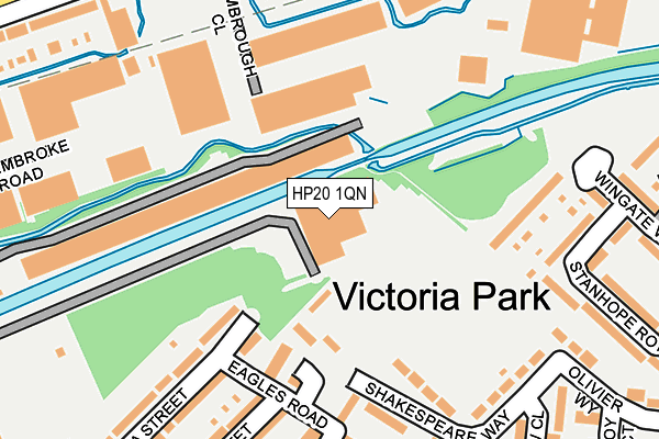
HP20 1QN is located in the Aylesbury East electoral ward, within the unitary authority of Buckinghamshire and the English Parliamentary constituency of Aylesbury. The Sub Integrated Care Board (ICB) Location is NHS Buckinghamshire, Oxfordshire and Berkshire West ICB - 14Y and the police force is Thames Valley. This postcode has been in use since October 2013.


GetTheData
Source: OS OpenMap – Local (Ordnance Survey)
Source: OS VectorMap District (Ordnance Survey)
Licence: Open Government Licence (requires attribution)
| Easting | 483154 |
| Northing | 213945 |
| Latitude | 51.817956 |
| Longitude | -0.795041 |
GetTheData
Source: Open Postcode Geo
Licence: Open Government Licence
| Country | England |
| Postcode District | HP20 |
➜ See where HP20 is on a map ➜ Where is Aylesbury? | |
GetTheData
Source: Land Registry Price Paid Data
Licence: Open Government Licence
Elevation or altitude of HP20 1QN as distance above sea level:
| Metres | Feet | |
|---|---|---|
| Elevation | 80m | 262ft |
Elevation is measured from the approximate centre of the postcode, to the nearest point on an OS contour line from OS Terrain 50, which has contour spacing of ten vertical metres.
➜ How high above sea level am I? Find the elevation of your current position using your device's GPS.
GetTheData
Source: Open Postcode Elevation
Licence: Open Government Licence
| Ward | Aylesbury East |
| Constituency | Aylesbury |
GetTheData
Source: ONS Postcode Database
Licence: Open Government Licence
| Grecian Street (Tring Road) | Aylesbury | 320m |
| Grecian Street (Tring Road) | Aylesbury | 331m |
| Tring Road Cemetery (Tring Road) | Aylesbury | 352m |
| Wingate Walk (Oakfield Road) | Aylesbury | 356m |
| Wingate Walk (Oakfield Road) | Aylesbury | 362m |
| Aylesbury Station | 1.5km |
| Stoke Mandeville Station | 3.4km |
| Aylesbury Vale Parkway Station | 4.7km |
GetTheData
Source: NaPTAN
Licence: Open Government Licence
GetTheData
Source: ONS Postcode Database
Licence: Open Government Licence


➜ Get more ratings from the Food Standards Agency
GetTheData
Source: Food Standards Agency
Licence: FSA terms & conditions
| Last Collection | |||
|---|---|---|---|
| Location | Mon-Fri | Sat | Distance |
| Walton Way | 17:30 | 12:00 | 349m |
| Printing Works | 17:00 | 12:00 | 401m |
| Douglas Road | 17:15 | 12:00 | 429m |
GetTheData
Source: Dracos
Licence: Creative Commons Attribution-ShareAlike
| Risk of HP20 1QN flooding from rivers and sea | Low |
| ➜ HP20 1QN flood map | |
GetTheData
Source: Open Flood Risk by Postcode
Licence: Open Government Licence
The below table lists the International Territorial Level (ITL) codes (formerly Nomenclature of Territorial Units for Statistics (NUTS) codes) and Local Administrative Units (LAU) codes for HP20 1QN:
| ITL 1 Code | Name |
|---|---|
| TLJ | South East (England) |
| ITL 2 Code | Name |
| TLJ1 | Berkshire, Buckinghamshire and Oxfordshire |
| ITL 3 Code | Name |
| TLJ13 | Buckinghamshire |
| LAU 1 Code | Name |
| E06000060 | Buckinghamshire |
GetTheData
Source: ONS Postcode Directory
Licence: Open Government Licence
The below table lists the Census Output Area (OA), Lower Layer Super Output Area (LSOA), and Middle Layer Super Output Area (MSOA) for HP20 1QN:
| Code | Name | |
|---|---|---|
| OA | E00169122 | |
| LSOA | E01017699 | Aylesbury Vale 014C |
| MSOA | E02003665 | Aylesbury Vale 014 |
GetTheData
Source: ONS Postcode Directory
Licence: Open Government Licence
| HP20 1EB | Park Street Industrial Estate | 119m |
| HP20 1LW | Denby Walk | 181m |
| HP20 1JF | Shakespeare Way | 201m |
| HP20 1LU | Queen Street | 235m |
| HP20 1LZ | Victoria Street | 238m |
| HP20 1LX | Albert Street | 238m |
| HP20 1LP | Stanhope Road | 245m |
| HP20 1LT | Grecian Street | 250m |
| HP20 1LY | Albert Street | 251m |
| HP20 1NA | Victoria Street | 254m |
GetTheData
Source: Open Postcode Geo; Land Registry Price Paid Data
Licence: Open Government Licence