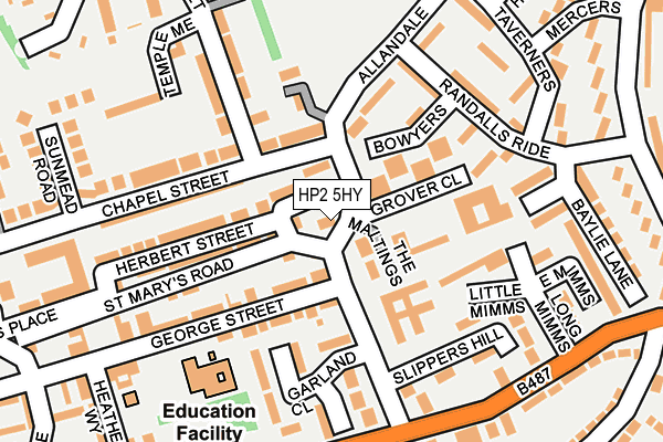
HP2 5HY is located in the Hemel Hempstead Town electoral ward, within the local authority district of Dacorum and the English Parliamentary constituency of Hemel Hempstead. The Sub Integrated Care Board (ICB) Location is NHS Hertfordshire and West Essex ICB - 06N and the police force is Hertfordshire. This postcode has been in use since January 1980.


GetTheData
Source: OS OpenMap – Local (Ordnance Survey)
Source: OS VectorMap District (Ordnance Survey)
Licence: Open Government Licence (requires attribution)
| Easting | 505896 |
| Northing | 207969 |
| Latitude | 51.760411 |
| Longitude | -0.467023 |
GetTheData
Source: Open Postcode Geo
Licence: Open Government Licence
| Country | England |
| Postcode District | HP2 |
| ➜ HP2 open data dashboard ➜ See where HP2 is on a map ➜ Where is Hemel Hempstead? | |
GetTheData
Source: Land Registry Price Paid Data
Licence: Open Government Licence
Elevation or altitude of HP2 5HY as distance above sea level:
| Metres | Feet | |
|---|---|---|
| Elevation | 120m | 394ft |
Elevation is measured from the approximate centre of the postcode, to the nearest point on an OS contour line from OS Terrain 50, which has contour spacing of ten vertical metres.
➜ How high above sea level am I? Find the elevation of your current position using your device's GPS.
GetTheData
Source: Open Postcode Elevation
Licence: Open Government Licence
| Ward | Hemel Hempstead Town |
| Constituency | Hemel Hempstead |
GetTheData
Source: ONS Postcode Database
Licence: Open Government Licence
| January 2024 | Violence and sexual offences | On or near Petrol Station | 258m |
| January 2024 | Criminal damage and arson | On or near Thumpers | 387m |
| January 2024 | Drugs | On or near Thumpers | 387m |
| ➜ Get more crime data in our Crime section | |||
GetTheData
Source: data.police.uk
Licence: Open Government Licence
| George Street (Allandale) | Highfield | 64m |
| George Street (Allandale) | Highfield | 92m |
| Randalls Ride (Allandale) | Highfield | 127m |
| Randalls Ride (Allandale) | Highfield | 176m |
| Allandale (Queensway) | Highfield | 196m |
| Hemel Hempstead Station | 2.6km |
| Apsley Station | 3.1km |
GetTheData
Source: NaPTAN
Licence: Open Government Licence
GetTheData
Source: ONS Postcode Database
Licence: Open Government Licence


➜ Get more ratings from the Food Standards Agency
GetTheData
Source: Food Standards Agency
Licence: FSA terms & conditions
| Last Collection | |||
|---|---|---|---|
| Location | Mon-Fri | Sat | Distance |
| Cattsdell | 17:15 | 12:00 | 16m |
| High Street | 17:30 | 12:00 | 425m |
| Queensway P.o. | 17:15 | 12:00 | 439m |
GetTheData
Source: Dracos
Licence: Creative Commons Attribution-ShareAlike
| Facility | Distance |
|---|---|
| George Street Primary School George Street, Hemel Hempstead Grass Pitches | 174m |
| Yew Tree Primary School Fletcher Way, Hemel Hempstead Grass Pitches | 633m |
| Gadebridge Lane Piccotts End, Hemel Hempstead Grass Pitches | 773m |
GetTheData
Source: Active Places
Licence: Open Government Licence
| School | Phase of Education | Distance |
|---|---|---|
| George Street Primary School George Street, Hemel Hempstead, HP2 5HJ | Primary | 124m |
| Yewtree Primary School Fletcher Way, Hemel Hempstead, HP2 5QR | Primary | 712m |
| Broadfield Academy Windmill Road, Hemel Hempstead, HP2 4BX | Primary | 925m |
GetTheData
Source: Edubase
Licence: Open Government Licence
The below table lists the International Territorial Level (ITL) codes (formerly Nomenclature of Territorial Units for Statistics (NUTS) codes) and Local Administrative Units (LAU) codes for HP2 5HY:
| ITL 1 Code | Name |
|---|---|
| TLH | East |
| ITL 2 Code | Name |
| TLH2 | Bedfordshire and Hertfordshire |
| ITL 3 Code | Name |
| TLH23 | Hertfordshire CC |
| LAU 1 Code | Name |
| E07000096 | Dacorum |
GetTheData
Source: ONS Postcode Directory
Licence: Open Government Licence
The below table lists the Census Output Area (OA), Lower Layer Super Output Area (LSOA), and Middle Layer Super Output Area (MSOA) for HP2 5HY:
| Code | Name | |
|---|---|---|
| OA | E00118867 | |
| LSOA | E01023399 | Dacorum 010C |
| MSOA | E02004865 | Dacorum 010 |
GetTheData
Source: ONS Postcode Directory
Licence: Open Government Licence
| HP2 5DT | Allandale | 32m |
| HP2 5JB | The Maltings | 55m |
| HP2 5AE | Chapel Street | 82m |
| HP2 5ZF | Allandale | 92m |
| HP2 5UZ | Clarendon Close | 97m |
| HP2 5HP | Herbert Street | 117m |
| HP2 5HW | Herbert Street | 117m |
| HP2 5AW | Chapel Street | 119m |
| HP2 5ZG | Honeypot Close | 119m |
| HP2 5AG | Bowyers | 128m |
GetTheData
Source: Open Postcode Geo; Land Registry Price Paid Data
Licence: Open Government Licence