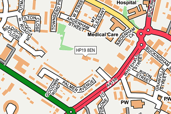
HP19 8EN is located in the Aylesbury North West electoral ward, within the unitary authority of Buckinghamshire and the English Parliamentary constituency of Aylesbury. The Sub Integrated Care Board (ICB) Location is NHS Buckinghamshire, Oxfordshire and Berkshire West ICB - 14Y and the police force is Thames Valley. This postcode has been in use since June 2000.


GetTheData
Source: OS OpenMap – Local (Ordnance Survey)
Source: OS VectorMap District (Ordnance Survey)
Licence: Open Government Licence (requires attribution)
| Easting | 481525 |
| Northing | 214078 |
| Latitude | 51.819391 |
| Longitude | -0.818637 |
GetTheData
Source: Open Postcode Geo
Licence: Open Government Licence
| Country | England |
| Postcode District | HP19 |
| ➜ HP19 open data dashboard ➜ See where HP19 is on a map ➜ Where is Aylesbury? | |
GetTheData
Source: Land Registry Price Paid Data
Licence: Open Government Licence
Elevation or altitude of HP19 8EN as distance above sea level:
| Metres | Feet | |
|---|---|---|
| Elevation | 80m | 262ft |
Elevation is measured from the approximate centre of the postcode, to the nearest point on an OS contour line from OS Terrain 50, which has contour spacing of ten vertical metres.
➜ How high above sea level am I? Find the elevation of your current position using your device's GPS.
GetTheData
Source: Open Postcode Elevation
Licence: Open Government Licence
| Ward | Aylesbury North West |
| Constituency | Aylesbury |
GetTheData
Source: ONS Postcode Database
Licence: Open Government Licence
| January 2024 | Public order | On or near Supermarket | 453m |
| January 2024 | Shoplifting | On or near Supermarket | 453m |
| January 2024 | Shoplifting | On or near Supermarket | 453m |
| ➜ Get more crime data in our Crime section | |||
GetTheData
Source: data.police.uk
Licence: Open Government Licence
| White Hill (Oxford Road) | Aylesbury | 162m |
| Royal Bucks Hospital (Bicester Road) | Aylesbury | 182m |
| Royal Bucks Hospital (Bicester Road) | Aylesbury | 195m |
| West Street (Bicester Road) | Aylesbury | 207m |
| West Street (Bicester Road) | Aylesbury | 215m |
| Aylesbury Station | 0.7km |
| Aylesbury Vale Parkway Station | 3.1km |
| Stoke Mandeville Station | 4.2km |
GetTheData
Source: NaPTAN
Licence: Open Government Licence
GetTheData
Source: ONS Postcode Database
Licence: Open Government Licence


➜ Get more ratings from the Food Standards Agency
GetTheData
Source: Food Standards Agency
Licence: FSA terms & conditions
| Last Collection | |||
|---|---|---|---|
| Location | Mon-Fri | Sat | Distance |
| Buckingham Street P.o. | 16:15 | 12:00 | 226m |
| Bicester Road | 17:00 | 12:00 | 277m |
| Friarage Road | 17:30 | 12:00 | 312m |
GetTheData
Source: Dracos
Licence: Creative Commons Attribution-ShareAlike
| Facility | Distance |
|---|---|
| The Gym Group (Aylesbury) Friars Square, Aylesbury Health and Fitness Gym, Studio | 574m |
| Puregym (Aylesbury) Aylesbury Shopping Park, Cambridge Close, Aylesbury Health and Fitness Gym, Studio | 645m |
| Body Flex Gym (Closed) Cambridge Street, Aylesbury Health and Fitness Gym | 664m |
GetTheData
Source: Active Places
Licence: Open Government Licence
| School | Phase of Education | Distance |
|---|---|---|
| Buckinghamshire College Group Oxford Road, Aylesbury, HP21 8PD | 16 plus | 675m |
| Elmhurst School Dunsham Lane, Aylesbury, HP20 2DB | Primary | 713m |
| Bearbrook Combined School Fowler Road, Aylesbury, HP19 7QP | Primary | 718m |
GetTheData
Source: Edubase
Licence: Open Government Licence
The below table lists the International Territorial Level (ITL) codes (formerly Nomenclature of Territorial Units for Statistics (NUTS) codes) and Local Administrative Units (LAU) codes for HP19 8EN:
| ITL 1 Code | Name |
|---|---|
| TLJ | South East (England) |
| ITL 2 Code | Name |
| TLJ1 | Berkshire, Buckinghamshire and Oxfordshire |
| ITL 3 Code | Name |
| TLJ13 | Buckinghamshire |
| LAU 1 Code | Name |
| E06000060 | Buckinghamshire |
GetTheData
Source: ONS Postcode Directory
Licence: Open Government Licence
The below table lists the Census Output Area (OA), Lower Layer Super Output Area (LSOA), and Middle Layer Super Output Area (MSOA) for HP19 8EN:
| Code | Name | |
|---|---|---|
| OA | E00089177 | |
| LSOA | E01017666 | Aylesbury Vale 013B |
| MSOA | E02003664 | Aylesbury Vale 013 |
GetTheData
Source: ONS Postcode Directory
Licence: Open Government Licence
| HP19 8EF | Palmer Avenue | 107m |
| HP19 8AB | Ardenham Lane | 107m |
| HP19 8AQ | Mount Pleasant | 113m |
| HP19 8FQ | Oxford Road | 120m |
| HP19 8AH | Ardenham Street | 121m |
| HP19 8EQ | Oxford Road | 129m |
| HP19 8EE | Goodwin Road | 141m |
| HP20 2JW | Whitehall Street | 162m |
| HP19 8AD | Bicester Road | 163m |
| HP19 8AA | Ardenham Lane | 164m |
GetTheData
Source: Open Postcode Geo; Land Registry Price Paid Data
Licence: Open Government Licence