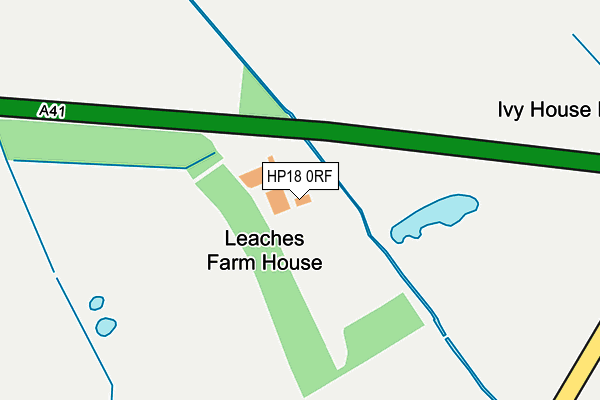
HP18 0RF is located in the Grendon Underwood electoral ward, within the unitary authority of Buckinghamshire and the English Parliamentary constituency of Buckingham. The Sub Integrated Care Board (ICB) Location is NHS Buckinghamshire, Oxfordshire and Berkshire West ICB - 14Y and the police force is Thames Valley. This postcode has been in use since January 1980.


GetTheData
Source: OS OpenMap – Local (Ordnance Survey)
Source: OS VectorMap District (Ordnance Survey)
Licence: Open Government Licence (requires attribution)
| Easting | 464975 |
| Northing | 219783 |
| Latitude | 51.872851 |
| Longitude | -1.057615 |
GetTheData
Source: Open Postcode Geo
Licence: Open Government Licence
| Country | England |
| Postcode District | HP18 |
➜ See where HP18 is on a map | |
GetTheData
Source: Land Registry Price Paid Data
Licence: Open Government Licence
Elevation or altitude of HP18 0RF as distance above sea level:
| Metres | Feet | |
|---|---|---|
| Elevation | 60m | 197ft |
Elevation is measured from the approximate centre of the postcode, to the nearest point on an OS contour line from OS Terrain 50, which has contour spacing of ten vertical metres.
➜ How high above sea level am I? Find the elevation of your current position using your device's GPS.
GetTheData
Source: Open Postcode Elevation
Licence: Open Government Licence
| Ward | Grendon Underwood |
| Constituency | Buckingham |
GetTheData
Source: ONS Postcode Database
Licence: Open Government Licence
| Percentage of properties with Next Generation Access | 50.0% |
| Percentage of properties with Superfast Broadband | 50.0% |
| Percentage of properties with Ultrafast Broadband | 50.0% |
| Percentage of properties with Full Fibre Broadband | 50.0% |
Superfast Broadband is between 30Mbps and 300Mbps
Ultrafast Broadband is > 300Mbps
| Median download speed | 50.0Mbps |
| Average download speed | 67.7Mbps |
| Maximum download speed | 250.00Mbps |
| Median upload speed | 50.0Mbps |
| Average upload speed | 66.9Mbps |
| Maximum upload speed | 250.00Mbps |
| Percentage of properties unable to receive 2Mbps | 50.0% |
| Percentage of properties unable to receive 5Mbps | 50.0% |
| Percentage of properties unable to receive 10Mbps | 50.0% |
| Percentage of properties unable to receive 30Mbps | 50.0% |
GetTheData
Source: Ofcom
Licence: Ofcom Terms of Use (requires attribution)
GetTheData
Source: ONS Postcode Database
Licence: Open Government Licence
| Last Collection | |||
|---|---|---|---|
| Location | Mon-Fri | Sat | Distance |
| Lugershall | 15:45 | 09:15 | 2,501m |
| Lower End Post Office | 16:15 | 09:15 | 2,506m |
| Swan Close | 16:45 | 07:30 | 2,736m |
GetTheData
Source: Dracos
Licence: Creative Commons Attribution-ShareAlike
| Risk of HP18 0RF flooding from rivers and sea | Medium |
| ➜ HP18 0RF flood map | |
GetTheData
Source: Open Flood Risk by Postcode
Licence: Open Government Licence
The below table lists the International Territorial Level (ITL) codes (formerly Nomenclature of Territorial Units for Statistics (NUTS) codes) and Local Administrative Units (LAU) codes for HP18 0RF:
| ITL 1 Code | Name |
|---|---|
| TLJ | South East (England) |
| ITL 2 Code | Name |
| TLJ1 | Berkshire, Buckinghamshire and Oxfordshire |
| ITL 3 Code | Name |
| TLJ13 | Buckinghamshire |
| LAU 1 Code | Name |
| E06000060 | Buckinghamshire |
GetTheData
Source: ONS Postcode Directory
Licence: Open Government Licence
The below table lists the Census Output Area (OA), Lower Layer Super Output Area (LSOA), and Middle Layer Super Output Area (MSOA) for HP18 0RF:
| Code | Name | |
|---|---|---|
| OA | E00089209 | |
| LSOA | E01017673 | Aylesbury Vale 010C |
| MSOA | E02003661 | Aylesbury Vale 010 |
GetTheData
Source: ONS Postcode Directory
Licence: Open Government Licence
| OX25 1QN | 925m | |
| OX25 1QG | 1299m | |
| OX25 1QF | Marsh Gibbon Road | 1457m |
| OX25 1QE | 1750m | |
| HP18 9PJ | Piddington Road | 1929m |
| HP18 9PQ | Piddington Road | 2140m |
| HP18 9PA | 2150m | |
| OX25 1QD | Lower End | 2341m |
| HP18 9NZ | The Green | 2430m |
| OX25 1PU | Ludgershall Road | 2501m |
GetTheData
Source: Open Postcode Geo; Land Registry Price Paid Data
Licence: Open Government Licence