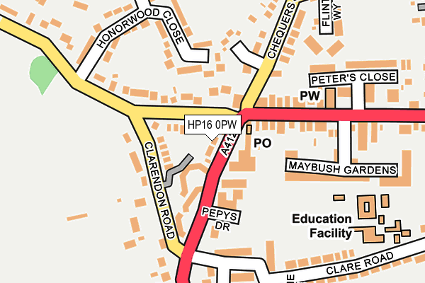
HP16 0PW lies on Wycombe Road in Prestwood, Great Missenden. HP16 0PW is located in the Great Missenden electoral ward, within the unitary authority of Buckinghamshire and the English Parliamentary constituency of Chesham and Amersham. The Sub Integrated Care Board (ICB) Location is NHS Buckinghamshire, Oxfordshire and Berkshire West ICB - 14Y and the police force is Thames Valley. This postcode has been in use since May 1994.


GetTheData
Source: OS OpenMap – Local (Ordnance Survey)
Source: OS VectorMap District (Ordnance Survey)
Licence: Open Government Licence (requires attribution)
| Easting | 486994 |
| Northing | 200829 |
| Latitude | 51.699474 |
| Longitude | -0.742624 |
GetTheData
Source: Open Postcode Geo
Licence: Open Government Licence
| Street | Wycombe Road |
| Locality | Prestwood |
| Town/City | Great Missenden |
| Country | England |
| Postcode District | HP16 |
| ➜ HP16 open data dashboard ➜ See where HP16 is on a map ➜ Where is Prestwood? | |
GetTheData
Source: Land Registry Price Paid Data
Licence: Open Government Licence
Elevation or altitude of HP16 0PW as distance above sea level:
| Metres | Feet | |
|---|---|---|
| Elevation | 200m | 656ft |
Elevation is measured from the approximate centre of the postcode, to the nearest point on an OS contour line from OS Terrain 50, which has contour spacing of ten vertical metres.
➜ How high above sea level am I? Find the elevation of your current position using your device's GPS.
GetTheData
Source: Open Postcode Elevation
Licence: Open Government Licence
| Ward | Great Missenden |
| Constituency | Chesham And Amersham |
GetTheData
Source: ONS Postcode Database
Licence: Open Government Licence
| January 2024 | Anti-social behaviour | On or near Parking Area | 247m |
| December 2023 | Violence and sexual offences | On or near John Hampden Way | 470m |
| November 2023 | Violence and sexual offences | On or near John Hampden Way | 470m |
| ➜ Wycombe Road crime map and outcomes | |||
GetTheData
Source: data.police.uk
Licence: Open Government Licence
| Village Hall (Wycombe Road) | Prestwood | 42m |
| Village Hall (Wycombe Road) | Prestwood | 57m |
| Sixty Acres Road (Wycombe Road) | Prestwood | 322m |
| Blacksmith Lane (High Street) | Prestwood | 341m |
| Blacksmith Lane (High Street) | Prestwood | 359m |
| Great Missenden Station | 2.4km |
GetTheData
Source: NaPTAN
Licence: Open Government Licence
| Percentage of properties with Next Generation Access | 100.0% |
| Percentage of properties with Superfast Broadband | 100.0% |
| Percentage of properties with Ultrafast Broadband | 0.0% |
| Percentage of properties with Full Fibre Broadband | 0.0% |
Superfast Broadband is between 30Mbps and 300Mbps
Ultrafast Broadband is > 300Mbps
| Percentage of properties unable to receive 2Mbps | 0.0% |
| Percentage of properties unable to receive 5Mbps | 0.0% |
| Percentage of properties unable to receive 10Mbps | 0.0% |
| Percentage of properties unable to receive 30Mbps | 0.0% |
GetTheData
Source: Ofcom
Licence: Ofcom Terms of Use (requires attribution)
GetTheData
Source: ONS Postcode Database
Licence: Open Government Licence


➜ Get more ratings from the Food Standards Agency
GetTheData
Source: Food Standards Agency
Licence: FSA terms & conditions
| Last Collection | |||
|---|---|---|---|
| Location | Mon-Fri | Sat | Distance |
| Prestwood P.o. | 17:30 | 11:15 | 63m |
| Greenlands Lane | 17:15 | 11:15 | 405m |
| High Street | 17:10 | 11:15 | 410m |
GetTheData
Source: Dracos
Licence: Creative Commons Attribution-ShareAlike
| Facility | Distance |
|---|---|
| Prestwood Junior School Clare Road, Prestwood, Great Missenden Grass Pitches | 257m |
| Prestwood Common Wrights Lane, Prestwood, Great Missenden Grass Pitches | 646m |
| Prestwood Recreation Ground Nairdwood Lane, Prestwood, Great Missenden Grass Pitches | 761m |
GetTheData
Source: Active Places
Licence: Open Government Licence
| School | Phase of Education | Distance |
|---|---|---|
| Prestwood Junior School Clare Road, Prestwood, Great Missenden, HP16 0NR | Primary | 258m |
| Prestwood Infant School Moat Lane, Prestwood, Great Missenden, HP16 9DF | Primary | 420m |
| Gateway School 1 High Street, Great Missenden, HP16 9AA | Not applicable | 2.4km |
GetTheData
Source: Edubase
Licence: Open Government Licence
The below table lists the International Territorial Level (ITL) codes (formerly Nomenclature of Territorial Units for Statistics (NUTS) codes) and Local Administrative Units (LAU) codes for HP16 0PW:
| ITL 1 Code | Name |
|---|---|
| TLJ | South East (England) |
| ITL 2 Code | Name |
| TLJ1 | Berkshire, Buckinghamshire and Oxfordshire |
| ITL 3 Code | Name |
| TLJ13 | Buckinghamshire |
| LAU 1 Code | Name |
| E06000060 | Buckinghamshire |
GetTheData
Source: ONS Postcode Directory
Licence: Open Government Licence
The below table lists the Census Output Area (OA), Lower Layer Super Output Area (LSOA), and Middle Layer Super Output Area (MSOA) for HP16 0PW:
| Code | Name | |
|---|---|---|
| OA | E00089741 | |
| LSOA | E01017788 | Chiltern 005F |
| MSOA | E02003680 | Chiltern 005 |
GetTheData
Source: ONS Postcode Directory
Licence: Open Government Licence
| HP16 9HF | High Street | 76m |
| HP16 9HD | High Street | 81m |
| HP16 0PH | Giles Gate | 83m |
| HP16 0NZ | Wycombe Road | 89m |
| HP16 9HG | Honor End Lane | 93m |
| HP16 9HB | High Street | 102m |
| HP16 9HA | High Street | 111m |
| HP16 0PL | Clarendon Road | 114m |
| HP16 9EZ | High Street | 120m |
| HP16 0NQ | Prestwood Place | 121m |
GetTheData
Source: Open Postcode Geo; Land Registry Price Paid Data
Licence: Open Government Licence